Schoonebeek
 flag |
 coat of arms |
| province |
|
| local community |
|
|
Area - land - water |
26.49 km 2 26.38 km 2 0.11 km 2 |
| Residents | 4,860 (Jan 1, 2018) |
| Coordinates | 52 ° 40 ′ N , 6 ° 53 ′ E |
| Important traffic route |
|
| prefix | 0524 |
| Postcodes | 7742, 7756, 7761, 7764-7766, 7787 |
| Location of Schoonebeek in the municipality of Emmen | |
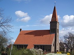
| Church in Schoonebeek | |
Schoonebeek is a place with 4,860 inhabitants (as of January 1, 2018) in the municipality of Emmen in the Dutch province of Drenthe . Schoonebeek is also called Oud-Schoonebeek , as the town of Nieuw-Schoonebeek , which also belongs to Emmen, is in the immediate vicinity.
geography
Schoonebeek is located east of Coevorden directly on the German border at Schoonebeker Diep , which forms the border between the Netherlands and Germany here. The neighboring municipality on German territory is Emlichheim .
history
Schoonebeek was first mentioned in a document in 1341 and, along with Ruinerwold, is one of the oldest places in Drenthe. Until the municipality reform in 1998, Schoonebeek was part of the Schoonebeek municipality, which was created in 1884 by a division between Schoonebeek and the former municipality of Dalen.
economy
From 1943 to 1996 petroleum was extracted in the municipality . In 1976 there was an oil spill that caused extensive damage. In 2006 it was investigated whether it would make sense to resume oil production, and in 2008 drilling was resumed. Oil has been produced again since 2011 and transported to Lingen in Germany via a 45 km pipeline . There, the further processing takes place in the Emsland oil refinery from BP .
Sights and events
- The place originally consisted of three parts, Westerse Bos , Middendorp and Oosterse Bos . There are several old farms here that are under protection.
- A disused oil pump can still be seen in the center.
- In the Zwaantje Hans-Stokman's Hof there is an annual competition in zandtapijt spreading (tapijt = carpet), in which patterns are spread on the floor with different colored sands.
- There are still some old sheep farms in Schoonebeek.
- Soldiers of the Royal Air Force , whose planes were shot down during World War II, are buried in the village cemetery.
politics
Allocation of seats in the municipal council Up until the dissolution of the municipality, the following allocation of seats resulted since 1982:
| Political party | Seats | |||
|---|---|---|---|---|
| 1982 | 1986 | 1990 | 1994 | |
| CDA | 6th | 5 | 5 | 4th |
| Onafhankelijke Partij Schoonebeek | 3 | 3 | 4th | 3 |
| PvdA | 2 | 3 | 3 | 2 |
| Community concerns | 2 | 1 | 1 | 2 |
| D66 | - | - | - | 1 |
| VVD | - | 1 | 0 | 1 |
| total | 13 | 13 | 13 | 13 |
Personalities
- Maruschka Detmers (* 1962), Dutch actress
- Erik Regtop (* 1968), Dutch football player
Web links
Individual evidence
- ↑ a b Kerncijfers wijken en buurten 2018 Centraal Bureau voor de Statistiek , accessed on September 11, 2018 (Dutch)
- ↑ Tagesschau: Oil production again in "Texas" in the Netherlands. ( Memento of January 27, 2011 in the Internet Archive ), January 24, 2011, accessed January 25, 2011
- ↑ Allocation of seats in the municipal council , accessed on September 11, 2018 (Dutch)


