
Voorthuizen: Difference between revisions
ClueBot NG (talk | contribs) m Reverting possible vandalism by 80.101.181.70 to version by Addbot. False positive? Report it. Thanks, ClueBot NG. (2122231) (Bot) |
Added history and religion segments |
||
| (20 intermediate revisions by 14 users not shown) | |||
| Line 1: | Line 1: | ||
{{Infobox settlement |
{{Infobox settlement |
||
|name = Voorthuizen |
| name = Voorthuizen |
||
| settlement_type = Village |
|||
|coordinates_region = NL |
|||
| other_name = <!-- if different from name --> |
|||
| ⚫ | |||
| native_name = <!-- if different from name --> |
|||
| ⚫ | |||
| native_name_lang = nl |
|||
| ⚫ | |||
| image_skyline = Voorthuizen, sculptuur de Voorthuizer Bunckmansage IMG 5062 2020-04-26 12.21.jpg |
|||
|subdivision_name1 = Gelderland |
|||
| ⚫ | |||
|subdivision_type2 = Municipality |
|||
| image_caption = Sculpture: the Voorthuizer Bunckmansage |
|||
| ⚫ | |||
| |
| image_flag = Voorthuizen vlag.svg |
||
| |
| image_shield = |
||
| ⚫ | |||
| ⚫ | |||
| |
| motto = |
||
| pushpin_map = Netherlands Gelderland#Netherlands |
|||
| ⚫ | |||
| pushpin_label_position = |
|||
| ⚫ | |||
| pushpin_mapsize = 250 |
|||
| ⚫ | |||
| pushpin_map_caption = Location in the province of Gelderland in the Netherlands |
|||
|website = |
|||
| ⚫ | |||
|image_flag = Voorthuizen vlag.svg |
|||
| ⚫ | |||
|latNS = N |
|||
| ⚫ | |||
|longEW = E |
|||
| |
| subdivision_name1 = [[Gelderland]] |
||
| |
| subdivision_type2 = Municipality |
||
| ⚫ | |||
| ⚫ | |||
| ⚫ | |||
| elevation_footnotes = <ref name="AHN">{{cite web |url = http://www.ahn.nl/postcodetool |title = Postcodetool for 3781AA |language = nl |work = Actueel Hoogtebestand Nederland |publisher = Het Waterschapshuis |access-date = 13 April 2022 }}</ref> |
|||
| ⚫ | |||
| |
| elevation_m = 13 |
||
| elevation_min_m = |
|||
| elevation_max_m = |
|||
| area_footnotes = <ref name="stat"/> |
|||
| area_total_km2 = 23.37 |
|||
| established_title = |
|||
| established_date = |
|||
| population_footnotes = <ref name="stat">{{cite web |url=https://www.cbs.nl/-/media/_excel/2021/48/kwb-2021.xls |title=Kerncijfers wijken en buurten 2021 |website=Central Bureau of Statistics |access-date=13 April 2022}}</ref> |
|||
| population_total = 11,340 |
|||
| ⚫ | |||
| population_demonym = |
|||
| population_note = |
|||
| population_density_km2 = auto |
|||
| timezone = [[Central European Time|CET]] |
|||
| utc_offset = +1 |
|||
| timezone_DST = [[Central European Summer Time|CEST]] |
|||
| utc_offset_DST = +2 |
|||
| postal_code_type = [[List of postal codes in the Netherlands|Postal code]] |
|||
| postal_code = 3781<ref name="stat"/> |
|||
| area_code_type = [[Telephone numbers in the Netherlands|Dialing code]] |
|||
| ⚫ | |||
| ⚫ | |||
| ⚫ | |||
| ⚫ | |||
| coordinates = {{coord|52|11|10|N|5|36|24|E|region:NL|display=title, inline}} |
|||
}} |
}} |
||
[[File:Voorthuizen, straatzicht met kerk1 op achtergrond foto3 2012-03-11 13.14.jpg|Voorthuizen, view to a street with church|thumb|255px|right]] |
|||
| ⚫ | |||
'''Voorthuizen ''' ([[Dutch Low Saxon]]: ''Voorthuzen'') is a village in the municipality of [[Barneveld (municipality)|Barneveld]], in the [[Netherlands|Dutch]] province of [[Gelderland]]. |
|||
| ⚫ | |||
<ref>{{Repertorium Nederlandse Gemeenten}}</ref> |
|||
== Tourism == |
|||
Voorthuizen is a [[tourist village]], located on the edge of the [[Veluwe]]. East of the village is a high concentration of campsites. To the southeast, on the [[A1 motorway (Netherlands)|A1]], lies the [[Recreatiegebied Zeumeren|Zeumeren]] recreation area, which attracts around 400,000 visitors per year. The tourist season has been opened since 2014 with a one-day event, "Voorthuizen Straalt!".<ref>{{Cite web |title=voorthuizenstraalt.nl |url=http://www.voorthuizenstraalt.nl/ |access-date=2023-05-03 |website=www.voorthuizenstraalt.nl}}</ref> |
|||
== History == |
|||
Voorthuizen was founded, according to legend, near a crossing of a ford ('Voorde') of the Ganzenbeek, a brook that no longer exists, on the road from [[Amsterdam]] to [[Deventer]]. This road was called a "Hessenweg" ('Hessian road') because seasonal workers from Westphalia would travel along this road into the Netherlands. Another important road that lead through this place was the trade route from [[Harderwijk]] to [[Wageningen]]. This made Voorthuizen an important stop along these two routes. |
|||
A new high road was commissioned and built by [[Louis Bonaparte|King Louis Bonaparte]] in 1809, which actually divided up the village. During the 20th century, traffic along this route through the center of the village increased, and a new main road was built in 1972, south of the village. |
|||
| ⚫ | |||
| ⚫ | Near the end of [[World War II]], many buildings in the village were heavily damaged due to an engagement between Canadian and German troops on 16-17 April 1945. In 1999, the [[Seaforth Highlanders]] of Holland pipe and drum band was founded to commemorate the liberation of the village in 1945 by the Seaforth Highlanders of [[British Columbia]]. |
||
Due to the increase of the military after the war, the number of military bases and garrisons was rapidly expanded, among others the nearby military base "De Wittenberg" in [[Garderen]]/Stroe (renamed Generaal Majoor Koot Kazerne in 1978), and a mobilization complex at the Garderbroekerweg in Voorthuizen. The influx of military personnel led to the expansion of the village in the early 1950s; one of these new neighborhoods that housed many servicemen -located according to rank,- soon was nicknamed "Klein Korea" ('Little Korea'). These new inhabitants, and others that followed, lead to a shift in the population, from traditional agricultural workers to a broader oriented populace, making Voorthuizen one of the more progressive villages in the municipality. |
|||
== Religion == |
|||
There are several churches in Voorthuizen, such as a number of [[Reformed Churches in the Netherlands|Reformed Churches]], the [[Catholic Church|Roman Catholic Church]], the [[New Apostolic Church]] and the [[Evangelical Congregational Church|Evangelical congregations]] of the Open Hof, the Kandelaar and Life. Since 2009, every year - on the fourth Sunday of June - all churches in Voorthuizen hold a joint open air service.<ref>{{Cite web |title=Openluchtdienst Voorthuizen elke 4e zondag van juni |url=https://openluchtdienstvoorthuizen.nl/ |access-date=2023-05-03 |language=nl}}</ref> |
|||
== Gallery == |
|||
<gallery> |
|||
File:Voorthuizen Bakkersweg 3-5.jpg|House in Voorthuizen |
|||
File:Voorthuizen, kerk2 foto1 RM8629 2012-03-11 13.19.JPG|The Dutch Reformed Church on the Kerkstraat |
|||
File:Overzicht van de achtergevel, gezien vanuit de tuin - Voorthuizen - 20388869 - RCE.jpg|House in Voorthuizen |
|||
File:Voorthuizen Gereformeerde kerk 1.jpg|Reformed Church on the Hoofdstraat |
|||
File:Maasjesland-gevel.jpg|Farm in Voorhuizen |
|||
</gallery> |
|||
==References== |
==References== |
||
<references/> |
<references/> |
||
{{Commons category|position=left}} |
|||
{{Coord|52|11|N|5|37|E|region:NL_type:city|display=title}} |
|||
{{Dutch municipality Barneveld}} |
|||
{{Authority control}} |
|||
[[Category:Populated places in Gelderland]] |
[[Category:Populated places in Gelderland]] |
||
[[Category:Former municipalities of Gelderland]] |
[[Category:Former municipalities of Gelderland]] |
||
[[Category:Barneveld (municipality)]] |
|||
{{Gelderland-geo-stub}} |
|||
Latest revision as of 14:29, 3 May 2023
Voorthuizen | |
|---|---|
Village | |
 Sculpture: the Voorthuizer Bunckmansage | |
 Flag | |
 Voorthuizen Location in the province of Gelderland in the Netherlands  Voorthuizen Voorthuizen (Netherlands) | |
| Coordinates: 52°11′10″N 5°36′24″E / 52.18611°N 5.60667°E | |
| Country | Netherlands |
| Province | Gelderland |
| Municipality | Barneveld |
| Area | |
| • Total | 23.37 km2 (9.02 sq mi) |
| Elevation | 13 m (43 ft) |
| Population (2021)[1] | |
| • Total | 11,340 |
| • Density | 490/km2 (1,300/sq mi) |
| Time zone | UTC+1 (CET) |
| • Summer (DST) | UTC+2 (CEST) |
| Postal code | 3781[1] |
| Dialing code | 0342 |
| Major roads | A1 N303 N344 |
Voorthuizen (Dutch Low Saxon: Voorthuzen) is a village in the municipality of Barneveld, in the Dutch province of Gelderland.
Tourism[edit]
Voorthuizen is a tourist village, located on the edge of the Veluwe. East of the village is a high concentration of campsites. To the southeast, on the A1, lies the Zeumeren recreation area, which attracts around 400,000 visitors per year. The tourist season has been opened since 2014 with a one-day event, "Voorthuizen Straalt!".[3]
History[edit]
Voorthuizen was founded, according to legend, near a crossing of a ford ('Voorde') of the Ganzenbeek, a brook that no longer exists, on the road from Amsterdam to Deventer. This road was called a "Hessenweg" ('Hessian road') because seasonal workers from Westphalia would travel along this road into the Netherlands. Another important road that lead through this place was the trade route from Harderwijk to Wageningen. This made Voorthuizen an important stop along these two routes.
A new high road was commissioned and built by King Louis Bonaparte in 1809, which actually divided up the village. During the 20th century, traffic along this route through the center of the village increased, and a new main road was built in 1972, south of the village.
Voorthuizen was a separate municipality between 1812 and 1818.[4]
Near the end of World War II, many buildings in the village were heavily damaged due to an engagement between Canadian and German troops on 16-17 April 1945. In 1999, the Seaforth Highlanders of Holland pipe and drum band was founded to commemorate the liberation of the village in 1945 by the Seaforth Highlanders of British Columbia.
Due to the increase of the military after the war, the number of military bases and garrisons was rapidly expanded, among others the nearby military base "De Wittenberg" in Garderen/Stroe (renamed Generaal Majoor Koot Kazerne in 1978), and a mobilization complex at the Garderbroekerweg in Voorthuizen. The influx of military personnel led to the expansion of the village in the early 1950s; one of these new neighborhoods that housed many servicemen -located according to rank,- soon was nicknamed "Klein Korea" ('Little Korea'). These new inhabitants, and others that followed, lead to a shift in the population, from traditional agricultural workers to a broader oriented populace, making Voorthuizen one of the more progressive villages in the municipality.
Religion[edit]
There are several churches in Voorthuizen, such as a number of Reformed Churches, the Roman Catholic Church, the New Apostolic Church and the Evangelical congregations of the Open Hof, the Kandelaar and Life. Since 2009, every year - on the fourth Sunday of June - all churches in Voorthuizen hold a joint open air service.[5]
Gallery[edit]
-
 House in Voorthuizen
 -
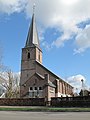 The Dutch Reformed Church on the Kerkstraat
 -
 House in Voorthuizen
 -
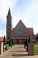 Reformed Church on the Hoofdstraat
 -
 Farm in Voorhuizen


References[edit]
- ^ a b c "Kerncijfers wijken en buurten 2021". Central Bureau of Statistics. Retrieved 13 April 2022.
- ^ "Postcodetool for 3781AA". Actueel Hoogtebestand Nederland (in Dutch). Het Waterschapshuis. Retrieved 13 April 2022.
- ^ "voorthuizenstraalt.nl". www.voorthuizenstraalt.nl. Retrieved 2023-05-03.
- ^ Ad van der Meer and Onno Boonstra, Repertorium van Nederlandse gemeenten, KNAW, 2011.
- ^ "Openluchtdienst Voorthuizen elke 4e zondag van juni" (in Dutch). Retrieved 2023-05-03.
| Authority control databases: National |
|---|