
Isa Lake: Difference between revisions
Craig Pass topo benchmark elevation 8262 ft |
m Removing link(s) Wikipedia:Articles for deletion/List of unusual drainage systems closed as delete (XFDcloser) |
||
| (27 intermediate revisions by 23 users not shown) | |||
| Line 1: | Line 1: | ||
{{Infobox |
{{Infobox body of water |
||
|name = Isa Lake |
|name = Isa Lake |
||
|image = Isa Lake YNP1.jpg |
|image = Isa Lake YNP1.jpg |
||
| Line 9: | Line 9: | ||
|type = Natural lake |
|type = Natural lake |
||
|inflow = |
|inflow = |
||
|outflow = [[Firehole River]] (west) (spring only) <br> [[Lewis River (Wyoming)|Lewis River]] (east) (spring and early summer) |
|||
|outflow = |
|||
|catchment = |
|catchment = |
||
|basin_countries = United States |
|basin_countries = United States |
||
| Line 23: | Line 23: | ||
|islands = |
|islands = |
||
|cities = |
|cities = |
||
<!-- Map --> |
|||
| pushpin_map = Wyoming#USA |
|||
| pushpin_label_position = |
|||
| pushpin_map_alt = Location of Isa Lake in Wyoming, USA. |
|||
| pushpin_map_caption = |
|||
<!-- Below --> |
|||
| website = |
|||
| reference = |
|||
}} |
}} |
||
'''Isa Lake''' is located in [[Yellowstone National Park]], in the [[U.S. state]] of [[Wyoming]].<ref>{{cite web| title =Craig Pass, USGS Craig Pass (WY) Topo Map |
'''Isa Lake''' is located in [[Yellowstone National Park]], in the [[U.S. state]] of [[Wyoming]].<ref>{{cite web| title =Craig Pass, USGS Craig Pass (WY) Topo Map| publisher =TopoQuest USGS Quads| url =http://www.topoquest.com/map.asp?lat=44.44083&lon=-110.71833&datum=nad27&u=4&layer=DRG&size=l&s=50| format =Map| access-date = 2008-06-29}}</ref> The lake straddles the [[Continental Divide of the Americas|continental divide]] at [[Craig Pass]]. [[Indigenous peoples of the Americas|Indigenous peoples]] have lived in the Yellowstone region for at least 11,000 years.<ref>{{cite web|title=Yellowstone, History and Culture|url=http://www.nps.gov/yell/historyculture/index.htm|url-status=live|archive-url=https://web.archive.org/web/20130922144249/http://www.nps.gov/yell/historyculture/index.htm|archive-date=September 22, 2013|access-date=October 24, 2021|publisher=National Park Service}}</ref> In the 1800s, at the time of [[Lewis and Clark Expedition|the first European exploration of the area]], the region was home to several [[First Nations in Canada|Indigenous Nations]] including the [[Nez Perce (tribe)|Nimíipuu]], [[Crow Indians|Absaroke]], and [[Shoshone]] [[Nation]]s. [[Hiram M. Chittenden]] became the first known European to sight the lake in 1891, while searching for the best routes connecting [[Old Faithful]] and the [[West Thumb Geyser Basin]]. Chittenden named the lake after Miss Isabel Jelke, from [[Cincinnati]], though it is not clear why.<ref name="isa">{{cite web | url =http://www.nps.gov/yell/planyourvisit/grant-area-nat-highs-5.htm | title = Isa Lake| work = Grant Area Natural Highlights | publisher = National Park Service| access-date = 2012-08-04}}</ref><ref>{{cite book | url=https://archive.org/details/bub_gb_9V1IAAAAMAAJ | title=The Origin of Certain Place Names in the United States | publisher=Govt. Print. Off. | author=Gannett, Henry | year=1905 | pages=[https://archive.org/details/bub_gb_9V1IAAAAMAAJ/page/n155 166]}}</ref> |
||
[[File:Continental Divide sign at Two-Ocean Lake.JPG|250px|thumb|right|Map of [[Continental Divide of the Americas|Continental Divide]] at Isa Lake]] |
[[File:Continental Divide sign at Two-Ocean Lake.JPG|250px|thumb|right|Map of [[Continental Divide of the Americas|Continental Divide]] at Isa Lake]] |
||
Isa Lake is believed to be the |
Isa Lake is believed to be one of the few natural lakes in the world which drain to two different oceans, another being [[Wollaston Lake]].<ref name="isa"/> (For similar cases see List of unusual drainage systems.) The east side of the lake drains by way of the [[Lewis River (Wyoming)|Lewis River]] to the [[Pacific Ocean]] and the west side of the lake drains by way of the [[Firehole River]] to the [[Gulf of Mexico]].<ref>{{cite web| url =http://www.wyomingtourism.org/articles/detail/Isa-Lake-in-Yellowstone-National-Park/405324| title =Isa Lake| publisher =Wyomingtourism.org| access-date =2012-08-04| archive-url =https://web.archive.org/web/20140921083101/http://www.wyomingtourism.org/articles/detail/Isa-Lake-in-Yellowstone-National-Park/405324| archive-date =2014-09-21| url-status =dead}}</ref> |
||
The lake is easy to visit as it is adjacent to the road that now connects the Old Faithful and West Thumb geysers basins, on what is known as the "lower loop" of the figure-eight roadway which traverses through Yellowstone. |
The lake is easy to visit as it is adjacent to the road that now connects the Old Faithful and West Thumb geysers basins, on what is known as the "lower loop" of the figure-eight roadway which traverses through Yellowstone. The [[Nuphar polysepala|great yellow pond-lily]] thrives in the lake. {{gallery |
||
{{gallery |
|||
|title=Images of Isa Lake |
|title=Images of Isa Lake |
||
|footer= |
|footer= |
||
|lines=3 |
|||
|width=150 |
|width=150 |
||
|File:IsaLake1921.jpg|Isa Lake, 1921 |
|File:IsaLake1921.jpg|Isa Lake, 1921 |
||
| Line 47: | Line 52: | ||
{{Upper Geyser Basin}} |
{{Upper Geyser Basin}} |
||
{{Wyoming}} |
{{Wyoming}} |
||
{{authority control}} |
|||
[[Category:Lakes of Teton County, Wyoming]] |
[[Category:Lakes of Teton County, Wyoming]] |
||
| Line 52: | Line 59: | ||
[[Category:Lakes of Yellowstone National Park]] |
[[Category:Lakes of Yellowstone National Park]] |
||
[[Category:Great Divide of North America]] |
[[Category:Great Divide of North America]] |
||
[[Category:Bifurcation lakes]] |
|||
Latest revision as of 13:01, 5 February 2024
| Isa Lake | |
|---|---|
 Isa Lake | |
 Isa Lake  Isa Lake | |
| Location | Yellowstone National Park, Teton County, Wyoming, US |
| Coordinates | 44°26′27″N 110°43′09″W / 44.44083°N 110.71917°W[1] |
| Type | Natural lake |
| Primary outflows | Firehole River (west) (spring only) Lewis River (east) (spring and early summer) |
| Basin countries | United States |
| Surface elevation | 8,262 feet (2,518 m)[1] |
Isa Lake is located in Yellowstone National Park, in the U.S. state of Wyoming.[2] The lake straddles the continental divide at Craig Pass. Indigenous peoples have lived in the Yellowstone region for at least 11,000 years.[3] In the 1800s, at the time of the first European exploration of the area, the region was home to several Indigenous Nations including the Nimíipuu, Absaroke, and Shoshone Nations. Hiram M. Chittenden became the first known European to sight the lake in 1891, while searching for the best routes connecting Old Faithful and the West Thumb Geyser Basin. Chittenden named the lake after Miss Isabel Jelke, from Cincinnati, though it is not clear why.[4][5]

Isa Lake is believed to be one of the few natural lakes in the world which drain to two different oceans, another being Wollaston Lake.[4] (For similar cases see List of unusual drainage systems.) The east side of the lake drains by way of the Lewis River to the Pacific Ocean and the west side of the lake drains by way of the Firehole River to the Gulf of Mexico.[6]
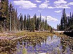
The lake is easy to visit as it is adjacent to the road that now connects the Old Faithful and West Thumb geysers basins, on what is known as the "lower loop" of the figure-eight roadway which traverses through Yellowstone. The great yellow pond-lily thrives in the lake.
-
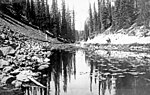 Isa Lake, 1921
 -
 Isa Lake on Craig Pass Road
 -
 Isa Lake


Notes[edit]
- ^ a b "Isa Lake". Geographic Names Information System. United States Geological Survey, United States Department of the Interior.
- ^ "Craig Pass, USGS Craig Pass (WY) Topo Map" (Map). TopoQuest USGS Quads. Retrieved 2008-06-29.
- ^ "Yellowstone, History and Culture". National Park Service. Archived from the original on September 22, 2013. Retrieved October 24, 2021.
- ^ a b "Isa Lake". Grant Area Natural Highlights. National Park Service. Retrieved 2012-08-04.
- ^ Gannett, Henry (1905). The Origin of Certain Place Names in the United States. Govt. Print. Off. pp. 166.
- ^ "Isa Lake". Wyomingtourism.org. Archived from the original on 2014-09-21. Retrieved 2012-08-04.
Yellowstone National Park - Upper Geyser Basin | ||
|---|---|---|
Geothermal features and other attractions in the Upper Geyser Basin | ||
| Geysers |
|  |
| Hot springs | ||
| Structures and history | ||
| Geography | ||
| ||
This article about a location in Wyoming is a stub. You can help Wikipedia by expanding it. |