
Dowdell's Knob: Difference between revisions
Content deleted Content added
No edit summary |
No edit summary |
||
| (30 intermediate revisions by 16 users not shown) | |||
| Line 1: | Line 1: | ||
{{Cleanup bare URLs|date=September 2022}} |
|||
| ⚫ | '''Dowdell's Knob''' is a prominent mountain in [[ |
||
{{Infobox mountain |
|||
| name = Dowdell's Knob |
|||
| photo = Dowdell knob.JPG |
|||
| photo_caption = View from the top of the mountain |
|||
| elevation_ft = 1395 |
|||
| elevation_ref = |
|||
| prominence_ft = 495 |
|||
| prominence_ref= |
|||
| location = [[Shiloh, Harris County, Georgia|Shiloh, Georgia]] |
|||
| range = [[Pine Mountain Range]] |
|||
| map = USA Georgia |
|||
| map_width = 200 |
|||
| label_position = right |
|||
| coordinates = {{coord|32.84069|-84.74576|region:US-GA_type:mountain|format=dms|display=inline,title}} |
|||
| topo = [[United States Geological Survey|USGS]] Shiloh |
|||
| first_ascent = 1932 |
|||
| easiest_route = [[Georgia State Route 190]] |
|||
}} |
|||
| ⚫ | '''Dowdell's Knob''' is a prominent mountain in [[Harris County, Georgia]].<ref>{{GNIS|355542}}</ref> It is the highest point in Harris County at {{convert|1,395|ft|m|abbr=off|sp=us}} above sea level and the highest point on the [[Pine Mountain Range]] in the area.<ref>http://www.cohp.org/ga/georgia_C.xml#Harris</ref> It is often referred to as a historical spot where former U.S. President [[Franklin D. Roosevelt]] would dine occasionally. He had a brick oven and picnic area constructed on this mountain for his use during his visits to nearby [[Warm Springs, Georgia|Warm Springs]]. Dowdell's Knob is located {{convert|66|mi|km|abbr=on}} south of [[Atlanta]] and {{convert|30|mi|km|abbr=on}} north of [[Columbus, Georgia|Columbus]]. |
||
The summit has the name of James and Lewis Dowdell, early settlers.<ref>{{cite book | url=http://www.kenkrakow.com/gpn/d.pdf | title=Georgia Place-Names: Their History and Origins | publisher=Winship Press | author=Krakow, Kenneth K. | year=1975 | location=Macon, GA | pages=64 | isbn=0-915430-00-2}}</ref> |
|||
<gallery> |
|||
File:16 24 125 FDR statue.jpg|bronze statue of [[Franklin D. Roosevelt]] |
|||
File:17 32 182 FDR statue.jpg|detail of statue |
|||
File:18-35-273-dowdell-knob.jpg|historical marker |
|||
File:21-07-024-dowdell.jpg|historical marker |
|||
</gallery> |
|||
==References== |
|||
{{Reflist}} |
|||
==External links== |
|||
* [http://georgiainfo.galileo.usg.edu/topics/historical_markers/county/harris/dowdells-knob Dowdell's Knob] historical marker |
|||
{{Mountains of Georgia (U.S. State)}} |
|||
[[Category:Mountains of Georgia (U.S. state)]] |
|||
[[Category:Landforms of Harris County, Georgia]] |
|||
Latest revision as of 19:00, 14 February 2024
| Dowdell's Knob | |
|---|---|
 View from the top of the mountain | |
| Highest point | |
| Elevation | 1,395 ft (425 m) |
| Prominence | 495 ft (151 m) |
| Coordinates | 32°50′26″N 84°44′45″W / 32.84069°N 84.74576°W |
| Geography | |
 Dowdell's Knob | |
| Parent range | Pine Mountain Range |
| Topo map | USGS Shiloh |
| Climbing | |
| First ascent | 1932 |
| Easiest route | Georgia State Route 190 |
Dowdell's Knob is a prominent mountain in Harris County, Georgia.[1] It is the highest point in Harris County at 1,395 feet (425 meters) above sea level and the highest point on the Pine Mountain Range in the area.[2] It is often referred to as a historical spot where former U.S. President Franklin D. Roosevelt would dine occasionally. He had a brick oven and picnic area constructed on this mountain for his use during his visits to nearby Warm Springs. Dowdell's Knob is located 66 mi (106 km) south of Atlanta and 30 mi (48 km) north of Columbus.
The summit has the name of James and Lewis Dowdell, early settlers.[3]
-
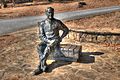 bronze statue of Franklin D. Roosevelt
 -
 detail of statue
 -
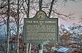 historical marker
 -
 historical marker


References[edit]
- ^ U.S. Geological Survey Geographic Names Information System: Dowdell's Knob
- ^ http://www.cohp.org/ga/georgia_C.xml#Harris
- ^ Krakow, Kenneth K. (1975). Georgia Place-Names: Their History and Origins (PDF). Macon, GA: Winship Press. p. 64. ISBN 0-915430-00-2.
External links[edit]
- Dowdell's Knob historical marker