
Ålgård: Difference between revisions
| (4 intermediate revisions by 4 users not shown) | |||
| Line 1: | Line 1: | ||
{{about|the village in Gjesdal, Norway||}} |
{{about|the village in Gjesdal, Norway||}} |
||
{{Use dmy dates|date= |
{{Use dmy dates|date=January 2024}} |
||
{{Infobox settlement |
{{Infobox settlement |
||
|official_name = Ålgård |
|official_name = Ålgård |
||
| Line 40: | Line 40: | ||
}} |
}} |
||
'''Ålgård''' (historic: ''Aalgaard'') is the [[administrative centre]] of [[Gjesdal]] municipality in [[Rogaland]] county, [[Norway]]. The village is located along the [[European route E39]] highway, about {{convert|10|km}} southeast of the [[Sandnes (town)|city of Sandnes]] in the [[Jæren]] district of the county. The village includes the neighborhoods of Ålgård, Bærland, Fiskebekk, Opstad and Solås. The large lake [[Edlandsvatnet]] lies on the south side of the village, emptying into the river [[Figgjoelva]] which runs northwest to Sandnes.<ref name="snl">{{Cite web |last= |
'''Ålgård''' (historic: ''Aalgaard'') is the [[administrative centre]] of [[Gjesdal]] municipality in [[Rogaland]] county, [[Norway]]. The village is located along the [[European route E39]] highway, about {{convert|10|km}} southeast of the [[Sandnes (town)|city of Sandnes]] in the [[Jæren]] district of the county. The village includes the neighborhoods of Ålgård, Bærland, Fiskebekk, Opstad and Solås. The large lake [[Edlandsvatnet]] lies on the south side of the village, emptying into the river [[Figgjoelva]] which runs northwest to Sandnes.<ref name="snl">{{Cite web |last=Thorsnæs |first=Geir |date=2022-12-28 |editor-last=Lauritzen |editor-first=Per Roger |title=Ålgård/Figgjo |url=https://snl.no/%C3%85lg%C3%A5rd%2FFiggjo |access-date=2023-05-06 |website=[[Great Norwegian Encyclopedia|Store norske leksikon]] |language=Norwegian}}</ref> |
||
Ålgård is mostly known for the [[Kongeparken]] amusement park, an old wool mill, and a local football team ([[Ålgård F.K.]]) playing in the [[List of football clubs in Norway|Norwegian Second Division]]. The [[Old Ålgård Church]] (built in 1917) and the new [[Ålgård Church]] (built in 2015) are both located in the village. There is significant industries in Ålgård, primarily the wood, textile, and clothing industries.<ref name="snl" /> |
Ålgård is mostly known for the [[Kongeparken]] amusement park, an old wool mill, and a local football team ([[Ålgård F.K.]]) playing in the [[List of football clubs in Norway|Norwegian Second Division]]. The [[Old Ålgård Church]] (built in 1917) and the new [[Ålgård Church]] (built in 2015) are both located in the village. There is significant industries in Ålgård, primarily the wood, textile, and clothing industries.<ref name="snl" /> |
||
| Line 48: | Line 48: | ||
==Notable residents== |
==Notable residents== |
||
Leo Moracchioli |
* [[Leo Moracchioli]] – Frog Leap Studios. |
||
* [[Martin Nevland]] – biathlete. |
|||
https://en.wikipedia.org/wiki/Leo_Moracchioli |
|||
==Media gallery== |
==Media gallery== |
||
| Line 61: | Line 61: | ||
{{Wikivoyage}} |
{{Wikivoyage}} |
||
{{reflist}} |
{{reflist}} |
||
{{authority control}} |
{{authority control}} |
||
Latest revision as of 13:37, 7 March 2024
Ålgård
Aalgaard (historic) | |
|---|---|
Village | |
 View of the village | |
 Ålgård Location in Rogaland county  Ålgård Ålgård (Norway) | |
| Coordinates: 58°45′50″N 05°51′09″E / 58.76389°N 5.85250°E | |
| Country | Norway |
| Region | Western Norway |
| County | Rogaland |
| District | Jæren |
| Municipality | Gjesdal |
| Area | |
| • Total | 4.18 km2 (1.61 sq mi) |
| Elevation | 94 m (308 ft) |
| Population (2019)[1] | |
| • Total | 9,277 |
| • Density | 2,219/km2 (5,750/sq mi) |
| Time zone | UTC+01:00 (CET) |
| • Summer (DST) | UTC+02:00 (CEST) |
| Post Code | 4330 Ålgård |
Ålgård (historic: Aalgaard) is the administrative centre of Gjesdal municipality in Rogaland county, Norway. The village is located along the European route E39 highway, about 10 kilometres (6.2 mi) southeast of the city of Sandnes in the Jæren district of the county. The village includes the neighborhoods of Ålgård, Bærland, Fiskebekk, Opstad and Solås. The large lake Edlandsvatnet lies on the south side of the village, emptying into the river Figgjoelva which runs northwest to Sandnes.[3]
Ålgård is mostly known for the Kongeparken amusement park, an old wool mill, and a local football team (Ålgård F.K.) playing in the Norwegian Second Division. The Old Ålgård Church (built in 1917) and the new Ålgård Church (built in 2015) are both located in the village. There is significant industries in Ålgård, primarily the wood, textile, and clothing industries.[3]
Population[edit]
The 4.18-square-kilometre (1,030-acre) village has a population (2019) of 9,277 and a population density of 2,219 inhabitants per square kilometre (5,750/sq mi).[1] The village of Figgjo, located in neighboring Sandnes municipality sits directly adjacent to Ålgård, just over the municipal border. Statistics Norway considers Ålgård/Figgjo to be one large urban area straddling two municipalities. Together, Ålgård/Figgjo has 11,335 residents.[1]
Notable residents[edit]
- Leo Moracchioli – Frog Leap Studios.
- Martin Nevland – biathlete.
Media gallery[edit]
-
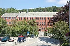 A former wool mill now used as a library and a cultural center
 -
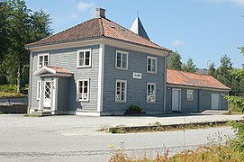 Ålgård Station, a former railway station for Ålgårdbanen
 -
 Ålgård Church was built in 1917. The architect was Ole Stein.


References[edit]
- ^ a b c d Statistisk sentralbyrå (1 January 2019). "Urban settlements. Population and area, by municipality".
- ^ "Ålgård, Gjesdal (Rogaland)" (in Norwegian). yr.no. Retrieved 2 March 2016.
- ^ a b Thorsnæs, Geir (28 December 2022). Lauritzen, Per Roger (ed.). "Ålgård/Figgjo". Store norske leksikon (in Norwegian). Retrieved 6 May 2023.
This Rogaland location article is a stub. You can help Wikipedia by expanding it. |