
Fort Larned National Historic Site: Difference between revisions
m →External links: Category:Historic districts in Kansas |
m Fixed typos (via WP:JWB) |
||
| (103 intermediate revisions by 62 users not shown) | |||
| Line 1: | Line 1: | ||
{{short description|National Historic Site of the United States}} |
|||
{{Infobox nrhp |
|||
{{redirect|Fort Larned|the horse|Fort Larned (horse)}} |
|||
| name = Fort Larned National Historic Site |
|||
{{Infobox NRHP |
|||
| nrhp_type = hd |
|||
| name = Fort Larned National Historic Site |
|||
| nrhp_type2 = nhs |
|||
| nrhp_type = hd |
|||
| image = Fort Larned quartermaster's building.jpg |
|||
| nocat = yes |
|||
| caption = Quartermaster's store building at Fort Larned |
|||
| nrhp_type2 = nhs |
|||
| location = [[Pawnee County, Kansas]], Kansas route 156, [[United States|USA]] |
|||
| image = Fort_Larned.jpg |
|||
| nearest_city= [[Larned, Kansas]] |
|||
| caption = Fort Larned Flagpole and Commissary Building |
|||
| lat_degrees = 38 |
|||
| location = [[Pawnee County, Kansas]], Kansas route 156, [[United States|USA]] |
|||
| lat_minutes = 9 |
|||
| nearest_city = [[Larned, Kansas]] |
|||
| lat_seconds = 24 |
|||
| coordinates = {{coord|38|10|59|N|99|13|05|W|region:US_type:landmark|format=dms|display=inline,title}} |
|||
| lat_direction = N |
|||
| locmapin = Kansas#USA |
|||
| long_degrees = 99 |
|||
| built = 1860 |
|||
| long_minutes = 13 |
|||
| architect = Quartermaster Dept., U.S. Army |
|||
| long_seconds = 36 |
|||
| architecture = |
|||
| long_direction = W |
|||
| added = October 15, 1966 |
|||
| locmapin = Kansas |
|||
| area = 718 acres (2.91 km<sup>2</sup>) |
|||
| coord_parameters = region:US_type:landmark |
|||
| designated_nrhp_type2 = August 31, 1964 |
|||
| coord_display = inline,title |
|||
| visitation_num = 21,895 |
|||
| coord_format = dms |
|||
| visitation_year = 2020 |
|||
| area = |
|||
| visitation_ref = <ref>{{cite web |title=Annual Visitation Highlights |url=https://irma.nps.gov/STATS/Reports/Park/FOLS |website=nps.gov |publisher=National Park Service |access-date=25 April 2021}}</ref> |
|||
| built = 1860 |
|||
| website = [https://www.nps.gov/fols/ Fort Larned National Historic Site] |
|||
| architect = Quartermaster Dept.,U.S. Army |
|||
| refnum = 66000107<ref name="nris">{{NRISref|2009a}}</ref> |
|||
| architecture = |
|||
| added = October 15, 1966 |
|||
| area = 718 acres (2.91 km²) |
|||
| designated_nrhp_type2 = August 31, 1964 |
|||
| visitation_num = 31,551 |
|||
| visitation_year = 2005 |
|||
| governing_body = [[National Park Service]] |
|||
| refnum = 66000107<ref name="nris">{{cite web|url=http://www.nr.nps.gov/|title=National Register Information System|date=2009-03-13|work=National Register of Historic Places|publisher=National Park Service}}</ref> |
|||
}} |
}} |
||
'''Fort Larned National Historic Site''' preserves '''Fort Larned''' which operated from 1859 to 1878. It is approximately {{Convert|5.5|mi|km}} west of [[Larned, Kansas|Larned]], [[Kansas]], United States. |
|||
'''Fort Larned National Historic Site''', located just west of [[Larned, Kansas|Larned]], [[Kansas]], [[United States]], preserves '''Fort Larned''', which was established in 1859 as a base of military operations against hostile Indians of the Central Plains, to protect traffic along the [[Santa Fe Trail]] and as an agency for the administration of the Central Plains Indians by the [[Bureau of Indian Affairs]] under the terms of the [[Fort Wise Treaty]] of 1861. With nine restored buildings, it survives as one of the best examples of [[Indian Wars]] period forts. Most of the buildings, including the barracks, commissary, and officers quarters, are furnished to their original appearance. |
|||
==History== |
|||
The buildings are built of a yellowish cut stone. The barracks follow the pattern familiar to Army trainees, with a large open bay with beds on each side of a central aisle. There was a room with a door at one end, a sergeant's room. What is unusual to living recruits is that there was no shower or toilet room at the end opposite the sergeant. |
|||
The [[Camp on Pawnee Fork]] was established on October 22, 1859, to protect traffic along the [[Santa Fe Trail]] from hostile Native Americans.<ref>{{cite web|url=http://www.nps.gov/fols/historyculture/index.htm|title=History and Culture|publisher=National Park Service|access-date=2013-12-16}}</ref> It was renamed Camp Alert in 1860, as the small garrison of about 50 men had to remain constantly alert for Indians. In May 1860 it was moved upstream, {{convert|3|mi|km}} 30 miles to the west up the Pawnee Fork, and by the end of the month was renamed Fort Larned. It served the same purpose as Camp Alert and as an agency for the administration of the Central Plains Indians by the [[Bureau of Indian Affairs]] under the terms of the [[Fort Wise Treaty]] of 1861. The fort's service ended as a combination of the tribes' relocation to reservations and the completion of railroads across Kansas that ended the need for the Santa Fe Trail. |
|||
Larned, Kansas and the fort that was constructed there are named in honor of Colonel [[Benjamin Larned|Benjamin F. Larned]], the paymaster general of the United States Army at the time the post was established. Larned experienced a lengthy military career, first serving as an ensign in the 21st Infantry during the War of 1812. He was promoted to captain after the defense of Fort Erie, and by 1854 Larned was a colonel and had been appointed paymaster general. Despite the town and fort bearing his name, Colonel Larned never came to Kansas. |
|||
As the American government claimed vast amounts of land west of the Mississippi River, trade and commerce with the territories grew exponentially. According to one source in 1859, trade had risen $10,000,000 annually. In the Missouri Republican, it was reported that 2,300 men, 1970 wagons, 840 horses, 4,000 mules, 15,000 oxen, 73 carriages, and over 1,900 tons of freight left Missouri for New Mexico. It became apparent an additional fortification was required to protect the trade routes. Fort Larned's location was chosen by William Bent, an agent for the Upper Arkansas Indians. Bent stated, "I consider it essential to have two permanent stations for troops, one at the mouth of Pawnee Fork, and one at Big Timbers, both upon the Arkansas River....To control them (the Indians), it is essential to have among them the perpetual presence of a controlling military force." |
|||
The fort's original structures were poorly constructed and inadequate. Built of adobe bricks, Fort Larned consisted of an officer's quarters, two combination storehouses and barracks, a guardhouse, two laundresses' quarters, and a hospital, with a bakery and meat house being later additions. After its establishment, nearby Plains Indians began to respect the trail commerce. In August, 1861, Colonel Leavenworth, reporting from Fort Larned, stated the Indians had left the Santa Fe trail area and there was no apprehension of any hostilities. |
|||
When the Civil War erupted in 1861, Fort Larned witnessed its first action and hostility from the Indians. Soldiers in the regular army were removed from the post to join the growing conflict in the East, leaving the fort to be operated by volunteer troops from Kansas, Colorado, and Wisconsin. Raids and harassment of travelers by Plains Indians increased during the Civil War years. On July 17, 1864, Kiowa Indians raided Fort Larned and stole 172 horses and mules from the corral. The raiders were pursued but never caught. In 1865 a system of escorting wagon trains was established, and all merchants were forbidden travel westward beyond Fort Larned without an armed escort. |
|||
Though the fort was never directly involved in any Civil War engagements, one incident nearly brought the fighting to Larned. In May 1862, Confederate General Albert Pike arranged an alliance with some Kiowa and Seminole Indians with intentions of capturing Forts Larned and Wise. The plan was never carried out, as the Indians left for their annual hunt when the weather improved. |
|||
Fort Larned was the site of a meeting between [[General Winfield Scott Hancock]] and several [[Cheyenne]] chiefs on April 12, 1867, in which Hancock intended to impress the [[Dog Soldier]] chiefs with his military power. After the meeting, Hancock, along with [[George Armstrong Custer]] and the [[7th U.S. Cavalry]] traveled west of Fort Larned to a combined Cheyenne and [[Lakota people|Lakota]] camp, inciting the villagers to flee. Hancock ordered the village burned, beginning a summer of warfare known as Hancock's War. Fort Larned assisted in bringing Hancock's War to an end by supplying the [[Medicine Lodge Treaty]].<ref>{{cite web|url=http://www.nps.gov/fols/historyculture/hancocks-war.htm|title=Hancock's War|publisher=National Park Service|access-date=2013-12-16}}</ref> During the winter of 1868–69, U.S. Major General Philip H. Sheridan launched a campaign against the Cheyenne, Kiowa, and Comanche Indians in the Great Plains region. Sheridan's men attacked any who resisted, taking their supplies and livestock and pushing the remaining Indians back into their reservations. By the end of the Winter Campaign, Sheridan had forced a majority of the Indians in the Fort Larned area on to reservations. |
|||
Renovations to Fort Larned took place between 1866 and 1868. The original sod and adobe structures were removed and replaced with the sandstone buildings that make up the fort today. By 1871, no escorts were required for the wagon trains traveling on the Santa Fe Trail, eliminating the need for military presence in the region. The post was abandoned on July 13, 1878, and on March 26, 1883, the Fort Larned Military Reservation was transferred from the War Department to the General Land Office of the Department of the Interior. |
|||
From 1885 to 1966, the buildings housed the headquarters of a [[ranch]], with the owners living in the house of the commanding officer and the employees residing in what had been the officers' quarters.<ref name=FAQ/> In 1957 the Fort Larned Historical Society was founded to develop and open the site as a tourist attraction. The fort was designated as a National Landmark in 1961, and in 1964 it was incorporated as a unit of the National Park System. |
|||
==Historic Site== |
|||
[[File:Fort larned 94.jpg|thumb|Schematic of Fort Larned National Historic site]] |
|||
'''Barracks''' – Barracks housed the [[infantry]] and [[cavalry]] on the north side of the Fort. The barracks housed up to four companies. On average, just 100 or 150 troops were stationed here. By 1868, a peak of 400 and 500. |
|||
'''Shops''' – Repairs were handled by skilled, civilian tradesmen. [[Blacksmiths]] and [[carpenters]] were hired at high wages. In 1867, a blacksmiths made $85 a month, [[saddles|saddlers]] and wheelwrights $90. Soldiers who had skills could take on extra duty working in the shops building as laborers, blacksmiths, and mechanics. The bakery was at the north end of the shops and baked bread. The bread was allowed to "dry" on racks for at least two days before being served. |
|||
'''Warehouses''' – An important role for a frontier fort was as a place to store the supplies that kept the Army functioning, including food, ammunition, and clothing. The first sandstone buildings completed after the blockhouse. The first two, the Old [[Commissary]] and the [[Quartermaster]] Storehouse, brandish loopholes from which the fort could be defended with rifle fire in the event of an attack. |
|||
'''Officers' Row''' – The company officers' quarters were designed to house four companies' of officers. A typical company's officers included two [[lieutenants]] and one [[captain (United States O-3)|captain]]. The officer' were divided into two halls, each with four rooms; a lieutenant was housed in one room while captains could claim two. In the rear of each half of the building was a kitchen and servant's quarters. |
|||
'''Blockhouse''' – The first sandstone structure to be completed was the blockhouse. It provided for defense. Built with two floor, each with loopholes to defend from attackers. It included an underground well. As the threat of attack diminished, the blockhouse was converted into the post's prison. The well tunnel was partially filled and used for solitary confinement. The rifle loopholes were also filled. The blockhouse is the only sandstone building that has been completely rebuilt, though it has been located on its original foundation. |
|||
<gallery> |
|||
File:Magazine P5310615.JPG|Blockhouse/Magazine/Prison |
|||
File:Barracks P5310605.JPG|Bunk Room in the Barracks |
|||
File:Officers Quarters P5310630.JPG|Junior Officer housing |
|||
File:Fort Larned National Historic Site FORTLA-1.jpg|Parade Grounds |
|||
File:Cemetery P5310614.JPG|Fort Larned Cemetery |
|||
File:Commissary P5310612.JPG|Warehouse |
|||
File:Fort Larned National Historic Site SOLDIE-1.jpg|Living History program |
|||
File:Commissary P5310638.JPG|Commissary |
|||
</gallery> |
|||
With nine historic buildings, the fort survives as one of the best-preserved examples of [[Indian Wars]]-period forts. Most of the buildings, including the [[barracks]], [[commissary]], and [[officers quarters]], are furnished to their original appearance. Fort Larned National Historic Site is open daily, year-round, and admission is free. The park offers several special events throughout the year, living history demonstrations, and ranger-guided tours.<ref name=FAQ>{{cite web|url=http://www.nps.gov/fols/faqs.htm|title=Frequently Asked Questions|publisher=National Park Service|access-date=2013-12-16}}</ref><ref>{{cite web|url=http://www.nps.gov/fols/planyourvisit/things2do.htm|title=Things to Do|publisher=National Park Service|access-date=2013-12-16}}</ref> |
|||
==Units stationed at Fort Larned== |
|||
The following units were stationed at Fort Larned during its 19 years of operation:<ref>{{cite web|url=http://www.nps.gov/fols/historyculture/regiments-and-years-served-at-fort-larned.htm|title=Regiments and Years Served at Fort Larned|publisher=National Park Service|access-date=2013-12-15}}</ref> |
|||
*[[1st U.S. Cavalry]] – 1859 |
|||
*[[2nd U.S. Infantry]] – 1859–63 |
|||
*[[2nd U.S. Dragoons]] – 1860–61 |
|||
*[[2nd Regiment Kansas Volunteer Cavalry]] – 1862 |
|||
*[[9th Regiment Kansas Volunteer Cavalry]] – 1862–64 |
|||
*[[2nd Colorado Volunteer Cavalry]] – 1862–65 |
|||
*[[9th Battery, Wisconsin Light Artillery]] – 1862–65 |
|||
*[[1st Colorado Volunteer Cavalry]] – 1862–64 |
|||
*[[12th Regiment Kansas Volunteer Infantry]] – 1863 |
|||
*[[McLain’s Independent Colorado Volunteer Battery]] – 1864 |
|||
*[[15th Regiment Kansas Volunteer Cavalry]] – 1864–65 |
|||
*[[3rd Wisconsin Volunteer Cavalry]] – 1864 |
|||
*[[11th Regiment Kansas Volunteer Cavalry]] – 1864–65 |
|||
*[[2nd U.S. Volunteer Infantry]] – 1865 |
|||
*[[48th Wisconsin Volunteer Infantry Regiment]] – 1865 |
|||
*[[17th Regiment Illinois Volunteer Cavalry]] – 1865 |
|||
*[[2nd U.S. Cavalry]] – 1865–66 |
|||
*[[13th U.S. Infantry]] – 1865 |
|||
*[[3rd U.S. Infantry]] – 1866–72 |
|||
*[[37th Infantry Division (United States)|37th U.S. Infantry]] – 1867 |
|||
*[[10th U.S. Cavalry]] – 1867–69 |
|||
*[[6th U.S. Infantry]] – 1871–72 |
|||
*[[5th U.S. Infantry]] – 1872–74 |
|||
*[[19th U.S. Infantry]] – 1874–78 |
|||
The 10th US Cavalry, stationed at Fort Larned from 1867 to 1869, was one of the first two all-black cavalry units utilized in the country, along with the 9th US Cavalry. On January 2, 1869, the 10th Cavalry's stables at Fort Larned burned to the ground. The fire killed dozens of horses, destroyed equipment, and caused the unit to be reassigned to [[Fort Zarah]].<ref>{{cite web|url=http://www.nps.gov/fols/historyculture/10th-cavalry-at-fort-larned.htm|title=10th Cavalry at Fort Larned|publisher=National Park Service|access-date=2013-12-16}}</ref> In 1999, [[magnetic gradiometry]] and [[electromagnetic conductivity]] surveys were conducted at the fort to attempt to determine the location of the stables, which had been lost. The surveys identified several areas of anomalies consistent with locations of buildings, as well as evidence of [[Disturbance (archaeology)|disturbances]] to the land that occurred after the buildings were no longer used as a fort.<ref>{{cite web|url=http://cast.uark.edu/nadag/projects_database/DeVore25/DeVore25.htm|title=Cavalry Stable Area (Fort Larned National Historic Site)|publisher=North American Database of Archaeological Geophysics|access-date=2013-12-16}}</ref> |
|||
==References== |
==References== |
||
{{ |
{{Reflist}} |
||
==External links== |
==External links== |
||
{{Commons category|Fort Larned National Historic Site}} |
|||
{{Portal|Kansas}} |
|||
* [http://www.santafetrailresearch.com/ Santa Fe Trail Research Site] |
|||
;Official Websites |
|||
*[http://www.kansastravel.org/fortlarned.htm Extensive photos of Fort Larned] |
|||
* [http://www.nps.gov/fols/ National Park Service: Fort Larned National Historic Site] |
|||
* [http://www.santafetrailcenter.org/ Santa Fe Trail Center], museum devoted to the history of the [[Santa Fe Trail]] in city of Larned |
|||
;Articles |
|||
{{Recreation.Gov|sourceURL=[http://recreation.gov/detail.cfm?ID=2693]}} |
|||
* [http://www.kshs.org/p/kansas-historical-quarterly-the-story-of-fort-larned/13139 ''The Story of Fort Larned''], 1957 article, Kansas Historical Quarterly |
|||
* [http://www.kansas.com/news/local/article1312915.html ''Fort Larned celebrates 50th anniversary as national park site''], 2014 article, The Wichita Eagle |
|||
* [http://www.kansastravel.org/fortlarned.htm Extensive photos of Fort Larned], kansastravel.org |
|||
;National Register of Historic Places |
|||
* {{NRHP url|id=66000107|title=NRHP Application}} |
|||
* {{NRHP url|id=66000107|title=NRHP Photos|photos=y}} |
|||
;Historic American Buildings Survey |
|||
*{{HABS |survey=KS-21 |id=ks0026 |title=Fort Larned, Barracks (West), Larned, Pawnee County, KS |photos=12 |color= |dwgs=5 |data= |cap=}} |
|||
*{{HABS |survey=KS-22 |id=ks0027 |title=Fort Larned, Barracks (East), Larned, Pawnee County, KS |photos=8 |color= |dwgs=5 |data= |cap=|link=no}} |
|||
*{{HABS |survey=KS-23 |id=ks0028 |title=Fort Larned, Blacksmith & Wheelwright Shop, Larned, Pawnee County, KS |photos=6 |color= |dwgs=4 |data= |cap=|link=no}} |
|||
*{{HABS |survey=KS-24 |id=ks0028 |title=Fort Larned, Bakery & Mess Hall, Larned, Pawnee County, KS |photos=5 |color= |dwgs=4 |data= |cap=|link=no}} |
|||
*{{HABS |survey=KS-25 |id=ks0030 |title=Fort Larned, Commissary Storehouse & Stables, Larned, Pawnee County, KS |photos=8 |color= |dwgs=4 |data= |cap=|link=no}} |
|||
*{{HABS |survey=KS-26 |id=ks0032 |title=Fort Larned, Quartermaster Storehouse, Larned, Pawnee County, KS |photos=6 |color= |dwgs=7 |data= |cap=|link=no}} |
|||
*{{HABS |survey=KS-27 |id=ks0033 |title=Fort Larned, Officers' Quarters (South), Larned, Pawnee County, KS |photos=11 |color= |dwgs=6 |data= |cap=|link=no}} |
|||
*{{HABS |survey=KS-28 |id=ks0031 |title=Fort Larned, Commanding Officer Quarters, Larned, Pawnee County, KS |photos=6 |color= |dwgs=7 |data= |cap=|link=no}} |
|||
*{{HABS |survey=KS-29 |id=ks0034 |title=Fort Larned, Officers' Quarters (North), Larned, Pawnee County, KS |photos=3 |color= |dwgs=6 |data= |cap=|link=no}} |
|||
;County Maps |
|||
* Pawnee County Maps: [http://www.ksdot.org/Assets/wwwksdotorg/bureaus/burTransPlan/maps/county-pdf/pawnee.PDF Current], [http://www.ksdot.org/bureaus/burtransplan/maps/PastPublishedCounty.asp Historic], KDOT |
|||
{{Registered Historic Places}} |
|||
{{Protected areas of Kansas}} |
|||
{{Authority control}} |
|||
[[Category:National Historic Landmarks in Kansas]] |
[[Category:National Historic Landmarks in Kansas]] |
||
[[Category:Recreational areas in Kansas |
[[Category:Recreational areas in Kansas]] |
||
[[Category:Santa Fe Trail]] |
[[Category:Santa Fe Trail]] |
||
[[Category:National Historic Sites in Kansas]] |
[[Category:National Historic Sites in Kansas]] |
||
[[Category:Forts in Kansas]] |
[[Category:Forts in Kansas|Larned]] |
||
[[Category:Historic districts in Kansas]] |
[[Category:Historic districts on the National Register of Historic Places in Kansas]] |
||
[[Category:Museums in Pawnee County, Kansas]] |
[[Category:Museums in Pawnee County, Kansas]] |
||
[[Category:Military and war museums in Kansas]] |
[[Category:Military and war museums in Kansas]] |
||
[[Category:Protected areas established in 1964]] |
|||
[[Category:Protected areas of Pawnee County, Kansas]] |
|||
{{US-NationalParkService-stub}} |
|||
[[Category:Historic American Buildings Survey in Kansas]] |
|||
{{US-protected-area-stub}} |
|||
[[Category:Forts on the National Register of Historic Places in Kansas|Larned]] |
|||
{{Kansas-NRHP-stub}} |
|||
[[Category:1859 establishments in Kansas Territory]] |
|||
{{Registered Historic Places}} |
|||
[[Category:National Register of Historic Places in Pawnee County, Kansas]] |
|||
{{Protected Areas of Kansas}} |
|||
[[Category:1964 establishments in Kansas]] |
|||
Latest revision as of 06:10, 13 April 2024
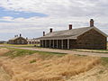
Fort Larned National Historic Site | |
 Fort Larned Flagpole and Commissary Building | |
  | |
| Location | Pawnee County, Kansas, Kansas route 156, USA |
|---|---|
| Nearest city | Larned, Kansas |
| Coordinates | 38°10′59″N 99°13′05″W / 38.18306°N 99.21806°W |
| Area | 718 acres (2.91 km2) |
| Built | 1860 |
| Architect | Quartermaster Dept., U.S. Army |
| Visitation | 21,895 (2020)[2] |
| Website | Fort Larned National Historic Site |
| NRHP reference No. | 66000107[1] |
| Significant dates | |
| Added to NRHP | October 15, 1966 |
| Designated NHS | August 31, 1964 |
Fort Larned National Historic Site preserves Fort Larned which operated from 1859 to 1878. It is approximately 5.5 miles (8.9 km) west of Larned, Kansas, United States.
History[edit]
The Camp on Pawnee Fork was established on October 22, 1859, to protect traffic along the Santa Fe Trail from hostile Native Americans.[3] It was renamed Camp Alert in 1860, as the small garrison of about 50 men had to remain constantly alert for Indians. In May 1860 it was moved upstream, 3 miles (4.8 km) 30 miles to the west up the Pawnee Fork, and by the end of the month was renamed Fort Larned. It served the same purpose as Camp Alert and as an agency for the administration of the Central Plains Indians by the Bureau of Indian Affairs under the terms of the Fort Wise Treaty of 1861. The fort's service ended as a combination of the tribes' relocation to reservations and the completion of railroads across Kansas that ended the need for the Santa Fe Trail.
Larned, Kansas and the fort that was constructed there are named in honor of Colonel Benjamin F. Larned, the paymaster general of the United States Army at the time the post was established. Larned experienced a lengthy military career, first serving as an ensign in the 21st Infantry during the War of 1812. He was promoted to captain after the defense of Fort Erie, and by 1854 Larned was a colonel and had been appointed paymaster general. Despite the town and fort bearing his name, Colonel Larned never came to Kansas.
As the American government claimed vast amounts of land west of the Mississippi River, trade and commerce with the territories grew exponentially. According to one source in 1859, trade had risen $10,000,000 annually. In the Missouri Republican, it was reported that 2,300 men, 1970 wagons, 840 horses, 4,000 mules, 15,000 oxen, 73 carriages, and over 1,900 tons of freight left Missouri for New Mexico. It became apparent an additional fortification was required to protect the trade routes. Fort Larned's location was chosen by William Bent, an agent for the Upper Arkansas Indians. Bent stated, "I consider it essential to have two permanent stations for troops, one at the mouth of Pawnee Fork, and one at Big Timbers, both upon the Arkansas River....To control them (the Indians), it is essential to have among them the perpetual presence of a controlling military force."
The fort's original structures were poorly constructed and inadequate. Built of adobe bricks, Fort Larned consisted of an officer's quarters, two combination storehouses and barracks, a guardhouse, two laundresses' quarters, and a hospital, with a bakery and meat house being later additions. After its establishment, nearby Plains Indians began to respect the trail commerce. In August, 1861, Colonel Leavenworth, reporting from Fort Larned, stated the Indians had left the Santa Fe trail area and there was no apprehension of any hostilities.
When the Civil War erupted in 1861, Fort Larned witnessed its first action and hostility from the Indians. Soldiers in the regular army were removed from the post to join the growing conflict in the East, leaving the fort to be operated by volunteer troops from Kansas, Colorado, and Wisconsin. Raids and harassment of travelers by Plains Indians increased during the Civil War years. On July 17, 1864, Kiowa Indians raided Fort Larned and stole 172 horses and mules from the corral. The raiders were pursued but never caught. In 1865 a system of escorting wagon trains was established, and all merchants were forbidden travel westward beyond Fort Larned without an armed escort.
Though the fort was never directly involved in any Civil War engagements, one incident nearly brought the fighting to Larned. In May 1862, Confederate General Albert Pike arranged an alliance with some Kiowa and Seminole Indians with intentions of capturing Forts Larned and Wise. The plan was never carried out, as the Indians left for their annual hunt when the weather improved.
Fort Larned was the site of a meeting between General Winfield Scott Hancock and several Cheyenne chiefs on April 12, 1867, in which Hancock intended to impress the Dog Soldier chiefs with his military power. After the meeting, Hancock, along with George Armstrong Custer and the 7th U.S. Cavalry traveled west of Fort Larned to a combined Cheyenne and Lakota camp, inciting the villagers to flee. Hancock ordered the village burned, beginning a summer of warfare known as Hancock's War. Fort Larned assisted in bringing Hancock's War to an end by supplying the Medicine Lodge Treaty.[4] During the winter of 1868–69, U.S. Major General Philip H. Sheridan launched a campaign against the Cheyenne, Kiowa, and Comanche Indians in the Great Plains region. Sheridan's men attacked any who resisted, taking their supplies and livestock and pushing the remaining Indians back into their reservations. By the end of the Winter Campaign, Sheridan had forced a majority of the Indians in the Fort Larned area on to reservations.
Renovations to Fort Larned took place between 1866 and 1868. The original sod and adobe structures were removed and replaced with the sandstone buildings that make up the fort today. By 1871, no escorts were required for the wagon trains traveling on the Santa Fe Trail, eliminating the need for military presence in the region. The post was abandoned on July 13, 1878, and on March 26, 1883, the Fort Larned Military Reservation was transferred from the War Department to the General Land Office of the Department of the Interior.
From 1885 to 1966, the buildings housed the headquarters of a ranch, with the owners living in the house of the commanding officer and the employees residing in what had been the officers' quarters.[5] In 1957 the Fort Larned Historical Society was founded to develop and open the site as a tourist attraction. The fort was designated as a National Landmark in 1961, and in 1964 it was incorporated as a unit of the National Park System.
Historic Site[edit]

Barracks – Barracks housed the infantry and cavalry on the north side of the Fort. The barracks housed up to four companies. On average, just 100 or 150 troops were stationed here. By 1868, a peak of 400 and 500.
Shops – Repairs were handled by skilled, civilian tradesmen. Blacksmiths and carpenters were hired at high wages. In 1867, a blacksmiths made $85 a month, saddlers and wheelwrights $90. Soldiers who had skills could take on extra duty working in the shops building as laborers, blacksmiths, and mechanics. The bakery was at the north end of the shops and baked bread. The bread was allowed to "dry" on racks for at least two days before being served.
Warehouses – An important role for a frontier fort was as a place to store the supplies that kept the Army functioning, including food, ammunition, and clothing. The first sandstone buildings completed after the blockhouse. The first two, the Old Commissary and the Quartermaster Storehouse, brandish loopholes from which the fort could be defended with rifle fire in the event of an attack.
Officers' Row – The company officers' quarters were designed to house four companies' of officers. A typical company's officers included two lieutenants and one captain. The officer' were divided into two halls, each with four rooms; a lieutenant was housed in one room while captains could claim two. In the rear of each half of the building was a kitchen and servant's quarters.
Blockhouse – The first sandstone structure to be completed was the blockhouse. It provided for defense. Built with two floor, each with loopholes to defend from attackers. It included an underground well. As the threat of attack diminished, the blockhouse was converted into the post's prison. The well tunnel was partially filled and used for solitary confinement. The rifle loopholes were also filled. The blockhouse is the only sandstone building that has been completely rebuilt, though it has been located on its original foundation.
-
 Blockhouse/Magazine/Prison
 -
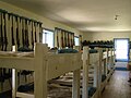 Bunk Room in the Barracks
 -
 Junior Officer housing
 -
 Parade Grounds
 -
 Fort Larned Cemetery
 -
 Warehouse
 -
 Living History program
 -
 Commissary


With nine historic buildings, the fort survives as one of the best-preserved examples of Indian Wars-period forts. Most of the buildings, including the barracks, commissary, and officers quarters, are furnished to their original appearance. Fort Larned National Historic Site is open daily, year-round, and admission is free. The park offers several special events throughout the year, living history demonstrations, and ranger-guided tours.[5][6]
Units stationed at Fort Larned[edit]
The following units were stationed at Fort Larned during its 19 years of operation:[7]
- 1st U.S. Cavalry – 1859
- 2nd U.S. Infantry – 1859–63
- 2nd U.S. Dragoons – 1860–61
- 2nd Regiment Kansas Volunteer Cavalry – 1862
- 9th Regiment Kansas Volunteer Cavalry – 1862–64
- 2nd Colorado Volunteer Cavalry – 1862–65
- 9th Battery, Wisconsin Light Artillery – 1862–65
- 1st Colorado Volunteer Cavalry – 1862–64
- 12th Regiment Kansas Volunteer Infantry – 1863
- McLain’s Independent Colorado Volunteer Battery – 1864
- 15th Regiment Kansas Volunteer Cavalry – 1864–65
- 3rd Wisconsin Volunteer Cavalry – 1864
- 11th Regiment Kansas Volunteer Cavalry – 1864–65
- 2nd U.S. Volunteer Infantry – 1865
- 48th Wisconsin Volunteer Infantry Regiment – 1865
- 17th Regiment Illinois Volunteer Cavalry – 1865
- 2nd U.S. Cavalry – 1865–66
- 13th U.S. Infantry – 1865
- 3rd U.S. Infantry – 1866–72
- 37th U.S. Infantry – 1867
- 10th U.S. Cavalry – 1867–69
- 6th U.S. Infantry – 1871–72
- 5th U.S. Infantry – 1872–74
- 19th U.S. Infantry – 1874–78
The 10th US Cavalry, stationed at Fort Larned from 1867 to 1869, was one of the first two all-black cavalry units utilized in the country, along with the 9th US Cavalry. On January 2, 1869, the 10th Cavalry's stables at Fort Larned burned to the ground. The fire killed dozens of horses, destroyed equipment, and caused the unit to be reassigned to Fort Zarah.[8] In 1999, magnetic gradiometry and electromagnetic conductivity surveys were conducted at the fort to attempt to determine the location of the stables, which had been lost. The surveys identified several areas of anomalies consistent with locations of buildings, as well as evidence of disturbances to the land that occurred after the buildings were no longer used as a fort.[9]
References[edit]
- ^ "National Register Information System". National Register of Historic Places. National Park Service. March 13, 2009.
- ^ "Annual Visitation Highlights". nps.gov. National Park Service. Retrieved 25 April 2021.
- ^ "History and Culture". National Park Service. Retrieved 2013-12-16.
- ^ "Hancock's War". National Park Service. Retrieved 2013-12-16.
- ^ a b "Frequently Asked Questions". National Park Service. Retrieved 2013-12-16.
- ^ "Things to Do". National Park Service. Retrieved 2013-12-16.
- ^ "Regiments and Years Served at Fort Larned". National Park Service. Retrieved 2013-12-15.
- ^ "10th Cavalry at Fort Larned". National Park Service. Retrieved 2013-12-16.
- ^ "Cavalry Stable Area (Fort Larned National Historic Site)". North American Database of Archaeological Geophysics. Retrieved 2013-12-16.
External links[edit]
- Official Websites
- National Park Service: Fort Larned National Historic Site
- Santa Fe Trail Center, museum devoted to the history of the Santa Fe Trail in city of Larned
- Articles
- The Story of Fort Larned, 1957 article, Kansas Historical Quarterly
- Fort Larned celebrates 50th anniversary as national park site, 2014 article, The Wichita Eagle
- Extensive photos of Fort Larned, kansastravel.org
- National Register of Historic Places
- Historic American Buildings Survey
- Historic American Buildings Survey (HABS) No. KS-21, "Fort Larned, Barracks (West), Larned, Pawnee County, KS", 12 photos, 5 measured drawings
- HABS No. KS-22, "Fort Larned, Barracks (East), Larned, Pawnee County, KS", 8 photos, 5 measured drawings
- HABS No. KS-23, "Fort Larned, Blacksmith & Wheelwright Shop, Larned, Pawnee County, KS", 6 photos, 4 measured drawings
- HABS No. KS-24, "Fort Larned, Bakery & Mess Hall, Larned, Pawnee County, KS", 5 photos, 4 measured drawings
- HABS No. KS-25, "Fort Larned, Commissary Storehouse & Stables, Larned, Pawnee County, KS", 8 photos, 4 measured drawings
- HABS No. KS-26, "Fort Larned, Quartermaster Storehouse, Larned, Pawnee County, KS", 6 photos, 7 measured drawings
- HABS No. KS-27, "Fort Larned, Officers' Quarters (South), Larned, Pawnee County, KS", 11 photos, 6 measured drawings
- HABS No. KS-28, "Fort Larned, Commanding Officer Quarters, Larned, Pawnee County, KS", 6 photos, 7 measured drawings
- HABS No. KS-29, "Fort Larned, Officers' Quarters (North), Larned, Pawnee County, KS", 3 photos, 6 measured drawings
- County Maps
| Topics | |
|---|---|
| Lists by state |
|
| Lists by insular areas | |
| Lists by associated state | |
| Other areas | |
| Related | |
| International | |
|---|---|
| National | |
| Other | |
- National Historic Landmarks in Kansas
- Recreational areas in Kansas
- Santa Fe Trail
- National Historic Sites in Kansas
- Forts in Kansas
- Historic districts on the National Register of Historic Places in Kansas
- Museums in Pawnee County, Kansas
- Military and war museums in Kansas
- Protected areas established in 1964
- Protected areas of Pawnee County, Kansas
- Historic American Buildings Survey in Kansas
- Forts on the National Register of Historic Places in Kansas
- 1859 establishments in Kansas Territory
- National Register of Historic Places in Pawnee County, Kansas
- 1964 establishments in Kansas