
Chyhyryn: Difference between revisions
NightOnEarth (talk | contribs) No edit summary |
removed Category:Former capitals of Ukraine using HotCat |
||
| (243 intermediate revisions by more than 100 users not shown) | |||
| Line 1: | Line 1: | ||
{{short description|Town in Cherkasy Oblast, Ukraine}} |
|||
'''Chyhyryn''' (Чигирин in [[Ukrainian language|Ukrainian]]), is a town in [[Cherkas'ka oblast'|Cherkasy region]] in central [[Ukraine]] with a population of approx. 12900. |
|||
{{Infobox settlement |
|||
| official_name = Chyhyryn |
|||
| native_name = {{lang|uk|Чигирин}} |
|||
| image_skyline = Резиденція Богдана Хмельницького, історико-архітектурний комплекс, аерофото.jpg |
|||
| imagesize = 280px |
|||
| image_caption = View of Chyhyryn |
|||
| image_flag = Flag of Chyhyryn.svg |
|||
| image_shield = Coat of arms of Chyhyryn.png |
|||
| mapsize = 250px |
|||
| map_caption = Map of Ukraine with Cherkasy Oblast highlighted. |
|||
| subdivision_type = [[Countries of the world|Country]] |
|||
| subdivision_name = {{UKR}} |
|||
| subdivision_type1 = [[Oblasts of Ukraine|Oblast]] |
|||
| subdivision_name1 = [[Cherkasy Oblast]] |
|||
| subdivision_type2 = [[Raions of Ukraine|Raion]] |
|||
| subdivision_name2 = [[Cherkasy Raion]] |
|||
| established_title = |
|||
| established_date = |
|||
| established_title1 = City rights |
|||
| established_date1 = 1592 |
|||
| leader_title = [[Mayor]] |
|||
| leader_name = Serhiy Oleksiiovych Tymchenko |
|||
| area_magnitude = |
|||
| area_total_km2 = 14 |
|||
| area_land_km2 = |
|||
| area_water_km2 = |
|||
| population_as_of = 2022 |
|||
| population_note = |
|||
| population_total = 8539 |
|||
| population_footnotes = |
|||
| population_metro = |
|||
| population_density_km2 = 854 |
|||
| pushpin_map = Ukraine Cherkasy Oblast#Ukraine |
|||
| pushpin_label_position = <!-- the position of the pushpin label: left, right, top, bottom, none --> |
|||
| pushpin_map_caption = Location of Chyhyryn |
|||
| pushpin_mapsize = |
|||
| coordinates = {{coord|49|04|38|N|32|38|57|E|region:UA|display=it}} |
|||
| elevation_m = 124| |
|||
| postal_code_type = [[Postal code]] |
|||
| postal_code = 20900-20906 |
|||
| area_code = +380 4730 |
|||
| blank_info = |
|||
| blank1_info = |
|||
| website = |
|||
| footnotes = |
|||
| subdivision_type3 = [[Hromada]] |
|||
| subdivision_name3 = [[Chyhyryn urban hromada]] |
|||
}} |
|||
[[File:Чигирин.jpeg|thumb|Remnants of fortification walls in 19th century (not preserved)]] |
|||
'''Chyhyryn''' ({{lang-uk|Чигирин}}, {{IPA-uk|tʃɪɦɪˈrɪn|pron}}; {{lang-pl|Czehryń}}, {{IPA-pl|ˈt͡ʂɛ.xrɨɲ|pron}}) is a [[List of cities in Ukraine|city]] in [[Cherkasy Raion]], [[Cherkasy Oblast]], central [[Ukraine]]. It is located on [[Tiasmyn]] river not far where it enters [[Dnieper]]. |
|||
From 1648 to 1669, the city served as the residence of the [[hetman of the Zaporizhian Host]]. After a forced relocation of the Ruthenian Orthodox metropolitan see from Kyiv in 1658, it became a full-fledged capital of the [[Cossack Hetmanate]]. Among Metropolitans who served out of Chyhyryn were family of Tukalsky: [[Dionysius Balaban]]-Tukalskyi and [[Joseph Tukalskyi-Nelyubovych]]. Chyhyryn also became a traditional place for the appointment to the office of the hetman of the Zaporizhian Host. |
|||
Since the 17th century, the significance of the settlement was diminished to a semi-rural populated place. It hosts the administration of {{ill|Chyhyryn urban hromada|uk|Чигиринська міська громада}}, one of the [[hromada]]s of Ukraine.<ref name="admreform_2020_chyhyryn">{{cite web |title=Чигиринська територіальна громада |url=https://decentralization.gov.ua/newgromada/4864/composition |publisher=decentralization.gov.ua |language=uk}}</ref> Population: {{Ua-pop-est2022|8539|punct=.}} |
|||
== Names == |
|||
Chyhyryn ({{lang-uk|Чигирин}}; [[Turkish language|Turkish]]: ''Çigirin'' or ''Çehrin''; {{lang-ru|Чигирин}}; {{lang-pl|Czehryń}}). On older maps it is often shown in Polish/Turkish-like transcription Czehrin (see [[Ch (digraph)]]). |
|||
== History == |
|||
[[File:Chyhyryn-3-eng.svg|thumb|upright=2|Map-scheme of the Chyhyryn fortress on the eve of the siege of 1678<br> |
|||
I - Central [[bastion]] or "bulwark" of the New Castle<br> |
|||
II - Bastion ("dungeon") of Doroshenko<br> |
|||
III - Bastion with the Crimean Tower<br> |
|||
IV - The Spassky Gate with a wooden tower and a double [[ravelin]] in front of them<br> |
|||
V - Wooden tower on a stone foundation, "New Goat Horn"<br> |
|||
VI - Tower and the well<br> |
|||
VII - Stone corner bastion<br> |
|||
VIII - Stone round tower<br> |
|||
IX - The Kyiv Tower with a gate to the bridge<br> |
|||
X - Noname tower (just built in 1678)<br> |
|||
XI - The Korsun or Mill Tower<br> |
|||
XII - Gate to the Lower Town]] |
|||
The area (1320–1569) had been part of the [[Grand Duchy of Lithuania]]. It was ceded to the [[Polish–Lithuanian Commonwealth]] (in the [[Kijów Voivodeship]] of the [[Crown of Poland]]) before the [[Union of Lublin]]. It was granted [[Magdeburg rights|Magdeburg Rights]] in 1592 by [[Sigismund III Vasa]]. |
|||
[[File:Czehryn, by Jan Jansson, circa 1663.jpg|thumb|left|upright=0.8|Chyhyryn on the [[Tiasmyn]]. A fragment of the ''Tractus Borysthenis Vulgo Dniepr at Niepr dicti'' map by Joannii Janssonii ([[Amsterdam]], 1663)]] |
|||
Chyhyryn is first mentioned as a fortified [[Cossack]] winter station. In 1638, [[Bohdan Khmelnytsky]] became its [[starosta]] (regional leader), and in 1648 it became the newly elected [[Hetman]]'s residence and the capital of the Cossack state, the [[Cossack Hetmanate|Zaporozhian Host]]. During the [[Russo-Turkish War (1676–1681)]] it was the center of two bloody campaigns (1675–76 and 1677–78). In 1678 the castle of Chyhyryn was blown up by the retreating Russian garrison that was stationed there, while the Turkish forces sacked the rest of the city. After this, it gradually lost its significance. The city fell under [[Ottoman Empire|Ottoman]] occupation but was later recovered by the [[Cossacks]] while the Ottomans were busy in the [[Battle of Vienna]]. It remained the center of the [[Chyhyryn regiment]] until 1712. In 1790 the 8th Polish National Cavalry Brigade was stationed in Czehryń and in 1792 the 4th Polish Vanguard Regiment was stationed there.<ref>{{cite book|last=Gembarzewski|first=Bronisław|title=Rodowody pułków polskich i oddziałów równorzędnych od r. 1717 do r. 1831|year=1925|language=pl|publisher=Towarzystwo Wiedzy Wojskowej|location=Warszawa|pages=10, 12}}</ref> It was annexed by the [[Russian Empire]] in the [[Second Partition of Poland]] (1793), and became part of the [[Kyiv]] region. |
|||
In 1917 a congress of [[Free Cossacks]] took place in Chyhyryn. At that congress by tradition [[Pavlo Skoropadsky]] was elected as the Hetman of the Cossacks (later in 1918 in [[Kyiv]], he was elected the [[Hetman of Ukraine]] as well). |
|||
During [[World War II]], Chyhyryn was occupied by the [[Wehrmacht|German Army]] from [[Operation Barbarossa|August 7, 1941]] to [[Battle of the Dnieper|December 12, 1943]]. |
|||
In 1989 the population of the city was 12,853.<ref>[http://demoscope.ru/weekly/ssp/sng89_reg2.php Всесоюзная перепись населения 1989 г. Численность городского населения союзных республик, их территориальных единиц, городских поселений и городских районов по полу]</ref> |
|||
Until 18 July 2020, Chyhyryn served as an administrative center of [[Chyhyryn Raion]]. The raion was abolished in July 2020 as part of the administrative reform of Ukraine, which reduced the number of raions of Cherkasy Oblast to four. The area of Chyhyryn Raion was merged into Cherkasy Raion.<ref>{{Cite news|title=Про утворення та ліквідацію районів. Постанова Верховної Ради України № 807-ІХ.|url=http://www.golos.com.ua/article/333466|access-date=2020-10-03|date=2020-07-18|website=Голос України|language=uk}}</ref><ref>{{cite web |title=Нові райони: карти + склад |url=https://www.minregion.gov.ua/press/news/novi-rajony-karty-sklad/ |publisher=Міністерство розвитку громад та територій України |language=Ukrainian}}</ref> |
|||
== Population == |
|||
=== Language === |
|||
Distribution of the population by native language according to the [[2001 Ukrainian census|2001 census]]:<ref>{{cite web | url=https://socialdata.org.ua/projects/mova-2001/ | title=Рідні мови в об'єднаних територіальних громадах України }}</ref> |
|||
{| class="standard" |
|||
|- |
|||
! Language |
|||
! Percentage |
|||
|- |
|||
| [[Ukrainian language|Ukrainian]] |
|||
| align="right"| 93.14% |
|||
|- |
|||
| [[Russian language in Ukraine|Russian]] |
|||
| align="right"| 5.37% |
|||
|- |
|||
| other/undecided |
|||
| align="right"| 1.49% |
|||
|} |
|||
==Geography== |
==Geography== |
||
===Location=== |
|||
The city is on the banks of [[Tiasmyn River]] and lies at an altitude of 124 metres [[above mean sea level]]. Minor industries, such as food and furniture factories, are the basis of the town economy in the 21st century. |
|||
===Climate=== |
|||
{{Weather box |
|||
|location = Chyhyryn (1981–2010) |
|||
|metric first = Yes |
|||
|single line = Yes |
|||
|width = auto |
|||
|Jan high C = -0.9 |
|||
|Feb high C = -0.1 |
|||
|Mar high C = 5.5 |
|||
|Apr high C = 14.4 |
|||
|May high C = 21.3 |
|||
|Jun high C = 24.3 |
|||
|Jul high C = 26.3 |
|||
|Aug high C = 25.9 |
|||
|Sep high C = 20.0 |
|||
|Oct high C = 13.0 |
|||
|Nov high C = 5.0 |
|||
|Dec high C = 0.4 |
|||
|year high C = 12.9 |
|||
|Jan mean C = -3.5 |
|||
|Feb mean C = -3.1 |
|||
|Mar mean C = 1.7 |
|||
|Apr mean C = 9.4 |
|||
|May mean C = 15.9 |
|||
|Jun mean C = 19.2 |
|||
|Jul mean C = 21.2 |
|||
|Aug mean C = 20.4 |
|||
|Sep mean C = 14.9 |
|||
|Oct mean C = 8.8 |
|||
|Nov mean C = 2.3 |
|||
|Dec mean C = -2.1 |
|||
|year mean C = 8.8 |
|||
|Jan low C = -6.1 |
|||
|Feb low C = -5.9 |
|||
|Mar low C = -1.5 |
|||
|Apr low C = 4.8 |
|||
|May low C = 10.4 |
|||
|Jun low C = 14.3 |
|||
|Jul low C = 16.1 |
|||
|Aug low C = 15.0 |
|||
|Sep low C = 10.4 |
|||
|Oct low C = 5.4 |
|||
|Nov low C = -0.2 |
|||
|Dec low C = -4.4 |
|||
|year low C = 4.9 |
|||
|precipitation colour = green |
|||
|Jan precipitation mm = 34.4 |
|||
|Feb precipitation mm = 32.9 |
|||
|Mar precipitation mm = 35.5 |
|||
|Apr precipitation mm = 36.7 |
|||
|May precipitation mm = 49.7 |
|||
|Jun precipitation mm = 77.1 |
|||
|Jul precipitation mm = 65.2 |
|||
|Aug precipitation mm = 54.2 |
|||
|Sep precipitation mm = 55.9 |
|||
|Oct precipitation mm = 42.1 |
|||
|Nov precipitation mm = 39.4 |
|||
|Dec precipitation mm = 37.0 |
|||
|year precipitation mm = 560.1 |
|||
|unit precipitation days = 1.0 mm |
|||
|Jan precipitation days = 7.4 |
|||
|Feb precipitation days = 7.1 |
|||
|Mar precipitation days = 7.3 |
|||
|Apr precipitation days = 7.0 |
|||
|May precipitation days = 7.2 |
|||
|Jun precipitation days = 8.5 |
|||
|Jul precipitation days = 7.1 |
|||
|Aug precipitation days = 6.3 |
|||
|Sep precipitation days = 6.5 |
|||
|Oct precipitation days = 5.7 |
|||
|Nov precipitation days = 6.8 |
|||
|Dec precipitation days = 7.4 |
|||
|year precipitation days = 84.3 |
|||
|Jan humidity = 83.5 |
|||
|Feb humidity = 80.8 |
|||
|Mar humidity = 76.6 |
|||
|Apr humidity = 66.9 |
|||
|May humidity = 63.2 |
|||
|Jun humidity = 68.0 |
|||
|Jul humidity = 68.0 |
|||
|Aug humidity = 66.4 |
|||
|Sep humidity = 71.9 |
|||
|Oct humidity = 76.9 |
|||
|Nov humidity = 84.0 |
|||
|Dec humidity = 85.1 |
|||
|year humidity = 74.3 |
|||
|source 1 = [[World Meteorological Organization]]<ref name=WMOCLINO>{{cite web |
|||
| archive-url = https://web.archive.org/web/20210717143555/https://www.ncei.noaa.gov/pub/data/normals/WMO/1981-2010/RA-VI/Ukraine/12.6.%20WMO_Normals_Excel_Template%20%282%29.xls |
|||
| archive-date = 17 July 2021 |
|||
| url = https://www.ncei.noaa.gov/pub/data/normals/WMO/1981-2010/RA-VI/Ukraine/12.6.%20WMO_Normals_Excel_Template%20(2).xls |
|||
| title = World Meteorological Organization Climate Normals for 1981–2010 |
|||
| publisher = World Meteorological Organization |
|||
| access-date = 17 July 2021}}</ref> |
|||
}} |
|||
==Landmarks== |
|||
*Located on the bank of [[Tyasmyn]] river. |
|||
The Trinity Monastery, built near Chyhyryn in 1627, was later destroyed by the [[Soviet Union|Soviet]] authorities. Other historical landmarks, such as the town hall and Khmelnytsky's palace, did not survive either. After Ukraine regained independence, Hetman's residence was restored and became a museum. |
|||
*Longitude: 49° 5' |
|||
*Longitude: 32° 40' |
|||
*Height above mean sea level: 124 m |
|||
== |
==Notable people== |
||
*[[Georgy Danilov]], linguist |
|||
*[[Bohdan Khmelnytsky]], hetman |
|||
*[[Kateryna_Yushchenko_(scientist)|Kateryna Yushchenko]], scientist |
|||
==International relations== |
|||
{{See also|List of twin towns and sister cities in Ukraine}} |
|||
===Twin towns — Sister cities=== |
|||
In the first half of the [[16th century]], Chyhyryn is first mentioned as a fortified [[Cossack]] winter station. In 1592, after becoming the center of Chyhyryn county, the city was granted the [[Magdeburg rights]]. In 1638, [[Bohdan Khmelnytsky]] became its starosta (regional leader), and in 1648 became the newly elected [[hetman]]'s residence and the capital of the [[Cossack Hetmanate]]. |
|||
Chyhyryn is [[town twinning|twinned]] with: |
|||
{| border="1" cellpadding="2" style="margin: 0 0 1em 1em; background: #ffffff; border: 1px #aaaaaa solid; border-collapse: collapse; font-size: 90%;" |
|||
!width="150" bgcolor=#f9f9f9|City |
|||
In 1660, the capital was moved to [[Baturyn]], and after Chyhyryn was raided by the [[Turks]] in 1678 it gradually lost its significance. It remained the center of the Chyhyryn regiment until 1712 and upon incorporation into the [[Russian Empire]] (1793) it became part of the [[Kiev]] region. |
|||
!width="100" bgcolor=#f9f9f9|Country |
|||
!width="100" bgcolor=#f9f9f9|Year of Signing |
|||
|- |
|||
|'''[[Sebastopol, California]]''' |
|||
|[[File:Flag of the United States.svg|25px]][[United States]] |
|||
|1993 |
|||
|} |
|||
==Gallery== |
|||
<gallery> |
|||
File:Chyhyryn1.jpg|Main square of Chyhyryn |
|||
File:Chyhyryn2.jpg|Entrance of the restored Bohdan Khmelnytskyi residence |
|||
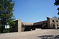
File:Chyhyryn3.jpg|Bohdan Khmelnytskyi residence |
|||
File:Chyhyryn4.jpg|St. Peter and St. Paul Church in Chyhyryn |
|||
File:Chyhyryn5.jpg|A statue near the church |
|||
File:Chyhyryn7.jpg|View of Chyhyryn from the city's Castle Hill |
|||
File:Chyhyryn9.jpg|Remnants of Chyhyryn Fortress on the Castle Hill (reconstructed) |
|||
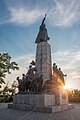
File:Chyhyryn Monument 01.jpg|Bohdan Khmelnytskyi monument in Chyhyryn |
|||
</gallery> |
|||
==See also== |
|||
The Trinity Monastery, built near Chyhyryn in 1627, was later destroyed by the [[Soviet]] authorities. Other historical landmarks, such as the town hall and Khmelnytsky's palace, did not survive either and today there are only remnants of fortifications. |
|||
* [[Perevolochna]], former fortress on [[Dnieper]] |
|||
==References== |
|||
{{reflist}} |
|||
== |
==External links== |
||
* [http://encyclopediaofukraine.com/display.asp?AddButton=pages\C\H\Chyhyryn.htm Chyhyryn] in the [http://encyclopediaofukraine.com Encyclopedia of Ukraine] |
|||
* [https://web.archive.org/web/20070120164727/http://sunsite.berkeley.edu:8085/x-ussr/100k/M-36-102.jpg Soviet topographic map 1:100,000] |
|||
* {{commons category-inline|Chyhyryn}} |
|||
{{Cherkasy Oblast}} |
|||
Minor industry, such as food and furniture factories, exist in the town today. |
|||
{{Capitals of Ukraine}} |
|||
{{Authority control}} |
|||
[[Category:Cities in Cherkasy Oblast]] |
|||
The area code is +38 (04730). |
|||
[[Category:Chigirinsky Uyezd]] |
|||
[[Category:Kiev Voivodeship]] |
|||
[[Category:Former national capitals]] |
|||
[[Category:Cities of district significance in Ukraine]] |
|||
[[Category:Cossack Hetmanate]] |
|||
[[Category:Forts in Ukraine]] |
|||
Latest revision as of 05:15, 6 June 2024
Chyhyryn
Чигирин | |
|---|---|
 View of Chyhyryn | |
 Flag  Coat of arms | |
 Chyhyryn Location of Chyhyryn  Chyhyryn Chyhyryn (Ukraine) | |
| Coordinates: 49°04′38″N 32°38′57″E / 49.07722°N 32.64917°E | |
| Country | |
| Oblast | Cherkasy Oblast |
| Raion | Cherkasy Raion |
| Hromada | Chyhyryn urban hromada |
| City rights | 1592 |
| Government | |
| • Mayor | Serhiy Oleksiiovych Tymchenko |
| Area | |
| • Total | 14 km2 (5 sq mi) |
| Elevation | 124 m (407 ft) |
| Population (2022) | |
| • Total | 8,539 |
| • Density | 854/km2 (2,210/sq mi) |
| Postal code | 20900-20906 |
| Area code | +380 4730 |

Chyhyryn (Ukrainian: Чигирин, pronounced [tʃɪɦɪˈrɪn]; Polish: Czehryń, pronounced [ˈt͡ʂɛ.xrɨɲ]) is a city in Cherkasy Raion, Cherkasy Oblast, central Ukraine. It is located on Tiasmyn river not far where it enters Dnieper.
From 1648 to 1669, the city served as the residence of the hetman of the Zaporizhian Host. After a forced relocation of the Ruthenian Orthodox metropolitan see from Kyiv in 1658, it became a full-fledged capital of the Cossack Hetmanate. Among Metropolitans who served out of Chyhyryn were family of Tukalsky: Dionysius Balaban-Tukalskyi and Joseph Tukalskyi-Nelyubovych. Chyhyryn also became a traditional place for the appointment to the office of the hetman of the Zaporizhian Host.
Since the 17th century, the significance of the settlement was diminished to a semi-rural populated place. It hosts the administration of Chyhyryn urban hromada, one of the hromadas of Ukraine.[1] Population: 8,539 (2022 estimate).[2]
Names[edit]
Chyhyryn (Ukrainian: Чигирин; Turkish: Çigirin or Çehrin; Russian: Чигирин; Polish: Czehryń). On older maps it is often shown in Polish/Turkish-like transcription Czehrin (see Ch (digraph)).
History[edit]

I - Central bastion or "bulwark" of the New Castle
II - Bastion ("dungeon") of Doroshenko
III - Bastion with the Crimean Tower
IV - The Spassky Gate with a wooden tower and a double ravelin in front of them
V - Wooden tower on a stone foundation, "New Goat Horn"
VI - Tower and the well
VII - Stone corner bastion
VIII - Stone round tower
IX - The Kyiv Tower with a gate to the bridge
X - Noname tower (just built in 1678)
XI - The Korsun or Mill Tower
XII - Gate to the Lower Town
The area (1320–1569) had been part of the Grand Duchy of Lithuania. It was ceded to the Polish–Lithuanian Commonwealth (in the Kijów Voivodeship of the Crown of Poland) before the Union of Lublin. It was granted Magdeburg Rights in 1592 by Sigismund III Vasa.

Chyhyryn is first mentioned as a fortified Cossack winter station. In 1638, Bohdan Khmelnytsky became its starosta (regional leader), and in 1648 it became the newly elected Hetman's residence and the capital of the Cossack state, the Zaporozhian Host. During the Russo-Turkish War (1676–1681) it was the center of two bloody campaigns (1675–76 and 1677–78). In 1678 the castle of Chyhyryn was blown up by the retreating Russian garrison that was stationed there, while the Turkish forces sacked the rest of the city. After this, it gradually lost its significance. The city fell under Ottoman occupation but was later recovered by the Cossacks while the Ottomans were busy in the Battle of Vienna. It remained the center of the Chyhyryn regiment until 1712. In 1790 the 8th Polish National Cavalry Brigade was stationed in Czehryń and in 1792 the 4th Polish Vanguard Regiment was stationed there.[3] It was annexed by the Russian Empire in the Second Partition of Poland (1793), and became part of the Kyiv region.
In 1917 a congress of Free Cossacks took place in Chyhyryn. At that congress by tradition Pavlo Skoropadsky was elected as the Hetman of the Cossacks (later in 1918 in Kyiv, he was elected the Hetman of Ukraine as well).
During World War II, Chyhyryn was occupied by the German Army from August 7, 1941 to December 12, 1943.
In 1989 the population of the city was 12,853.[4]
Until 18 July 2020, Chyhyryn served as an administrative center of Chyhyryn Raion. The raion was abolished in July 2020 as part of the administrative reform of Ukraine, which reduced the number of raions of Cherkasy Oblast to four. The area of Chyhyryn Raion was merged into Cherkasy Raion.[5][6]
Population[edit]
Language[edit]
Distribution of the population by native language according to the 2001 census:[7]
| Language | Percentage |
|---|---|
| Ukrainian | 93.14% |
| Russian | 5.37% |
| other/undecided | 1.49% |
Geography[edit]
Location[edit]
The city is on the banks of Tiasmyn River and lies at an altitude of 124 metres above mean sea level. Minor industries, such as food and furniture factories, are the basis of the town economy in the 21st century.
Climate[edit]
| Climate data for Chyhyryn (1981–2010) | |||||||||||||
|---|---|---|---|---|---|---|---|---|---|---|---|---|---|
| Month | Jan | Feb | Mar | Apr | May | Jun | Jul | Aug | Sep | Oct | Nov | Dec | Year |
| Mean daily maximum °C (°F) | −0.9 (30.4) |
−0.1 (31.8) |
5.5 (41.9) |
14.4 (57.9) |
21.3 (70.3) |
24.3 (75.7) |
26.3 (79.3) |
25.9 (78.6) |
20.0 (68.0) |
13.0 (55.4) |
5.0 (41.0) |
0.4 (32.7) |
12.9 (55.2) |
| Daily mean °C (°F) | −3.5 (25.7) |
−3.1 (26.4) |
1.7 (35.1) |
9.4 (48.9) |
15.9 (60.6) |
19.2 (66.6) |
21.2 (70.2) |
20.4 (68.7) |
14.9 (58.8) |
8.8 (47.8) |
2.3 (36.1) |
−2.1 (28.2) |
8.8 (47.8) |
| Mean daily minimum °C (°F) | −6.1 (21.0) |
−5.9 (21.4) |
−1.5 (29.3) |
4.8 (40.6) |
10.4 (50.7) |
14.3 (57.7) |
16.1 (61.0) |
15.0 (59.0) |
10.4 (50.7) |
5.4 (41.7) |
−0.2 (31.6) |
−4.4 (24.1) |
4.9 (40.8) |
| Average precipitation mm (inches) | 34.4 (1.35) |
32.9 (1.30) |
35.5 (1.40) |
36.7 (1.44) |
49.7 (1.96) |
77.1 (3.04) |
65.2 (2.57) |
54.2 (2.13) |
55.9 (2.20) |
42.1 (1.66) |
39.4 (1.55) |
37.0 (1.46) |
560.1 (22.05) |
| Average precipitation days (≥ 1.0 mm) | 7.4 | 7.1 | 7.3 | 7.0 | 7.2 | 8.5 | 7.1 | 6.3 | 6.5 | 5.7 | 6.8 | 7.4 | 84.3 |
| Average relative humidity (%) | 83.5 | 80.8 | 76.6 | 66.9 | 63.2 | 68.0 | 68.0 | 66.4 | 71.9 | 76.9 | 84.0 | 85.1 | 74.3 |
| Source: World Meteorological Organization[8] | |||||||||||||
Landmarks[edit]
The Trinity Monastery, built near Chyhyryn in 1627, was later destroyed by the Soviet authorities. Other historical landmarks, such as the town hall and Khmelnytsky's palace, did not survive either. After Ukraine regained independence, Hetman's residence was restored and became a museum.
Notable people[edit]
- Georgy Danilov, linguist
- Bohdan Khmelnytsky, hetman
- Kateryna Yushchenko, scientist
International relations[edit]
Twin towns — Sister cities[edit]
Chyhyryn is twinned with:
| City | Country | Year of Signing |
|---|---|---|
| Sebastopol, California | 1993 |
Gallery[edit]
-
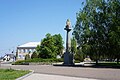 Main square of Chyhyryn
 -
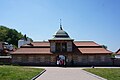 Entrance of the restored Bohdan Khmelnytskyi residence
 -
 Bohdan Khmelnytskyi residence
 -
 St. Peter and St. Paul Church in Chyhyryn
 -
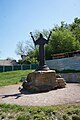 A statue near the church
 -
 View of Chyhyryn from the city's Castle Hill
 -
 Remnants of Chyhyryn Fortress on the Castle Hill (reconstructed)
 -
 Bohdan Khmelnytskyi monument in Chyhyryn


See also[edit]
- Perevolochna, former fortress on Dnieper
References[edit]
- ^ "Чигиринська територіальна громада" (in Ukrainian). decentralization.gov.ua.
- ^ Чисельність наявного населення України на 1 січня 2022 [Number of Present Population of Ukraine, as of January 1, 2022] (PDF) (in Ukrainian and English). Kyiv: State Statistics Service of Ukraine. Archived (PDF) from the original on 4 July 2022.
- ^ Gembarzewski, Bronisław (1925). Rodowody pułków polskich i oddziałów równorzędnych od r. 1717 do r. 1831 (in Polish). Warszawa: Towarzystwo Wiedzy Wojskowej. pp. 10, 12.
- ^ Всесоюзная перепись населения 1989 г. Численность городского населения союзных республик, их территориальных единиц, городских поселений и городских районов по полу
- ^ "Про утворення та ліквідацію районів. Постанова Верховної Ради України № 807-ІХ". Голос України (in Ukrainian). 2020-07-18. Retrieved 2020-10-03.
- ^ "Нові райони: карти + склад" (in Ukrainian). Міністерство розвитку громад та територій України.
- ^ "Рідні мови в об'єднаних територіальних громадах України".
- ^ "World Meteorological Organization Climate Normals for 1981–2010". World Meteorological Organization. Archived from the original on 17 July 2021. Retrieved 17 July 2021.
External links[edit]
- Chyhyryn in the Encyclopedia of Ukraine
- Soviet topographic map 1:100,000
 Media related to Chyhyryn at Wikimedia Commons
Historical capitals in Ukraine | |||||||||
|---|---|---|---|---|---|---|---|---|---|
| Medieval and early modern capitals |
| ||||||||
| Ukrainian states after the Russian Empire and before the Ukrainian SSR |
| ||||||||
| Ukrainian SSR (since 1919), independent Ukraine (since 1991), other contemporary states |
| ||||||||
| International | |
|---|---|
| National | |
| Other | |