
Pahranagat National Wildlife Refuge
| Pahranagat National Wildlife Refuge | |
|---|---|
IUCN category IV (habitat/species management area) | |
 Pahranagat National Wildlife Refuge Upper Lake | |
| Lua error in Module:Location_map at line 526: Unable to find the specified location map definition: "Module:Location map/data/USA relief" does not exist. | |
| Location | Lincoln County, Nevada, United States |
| Nearest city | Glendale, Nevada |
| Area | 5,380 acres (21.8 km2) |
| Established | 1963 |
| Governing body | U.S. Fish and Wildlife Service |
| www | |
The Pahranagat National Wildlife Refuge is a protected wildlife refuge, located at the southern end of the Pahranagat Valley and administered by the U.S. Fish and Wildlife Service. It is situated 90 miles (140 km) north of Las Vegas, Nevada in Lincoln County, Nevada. The 5,380-acre (21.8 km2) refuge was created on August 16, 1963 and is part of the larger Desert National Wildlife Refuge Complex, which also includes the Ash Meadows National Wildlife Refuge, the Desert National Wildlife Refuge, the Moapa Valley National Wildlife Refuge, and the Amargosa Pupfish Station.
Located within the Pacific Flyway, the refuge provides high quality migration and wintering habitat for migrating birds, with emphasis on waterfowl.
History
Work is underway to restore wetland and desert upland habitats to what was found on the refuge over 100 years ago.
Species of concern that spend part of the year at Pahranagat
Endangered
Endangered species include:
Threatened
Threatened species include:
Image Gallery
-
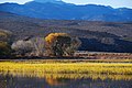 Contrasting landscape of the wildlife refuge
 -
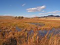 The middle marsh
 -
 One of the springs undergoing restoration
 -
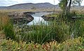
 Waters of the wildlife refuge
 -
 Waterfowl in the refuge
 -


References
![]() This article incorporates public domain material from websites or documents of the United States Fish and Wildlife Service.
This article incorporates public domain material from websites or documents of the United States Fish and Wildlife Service.
External links
- Pahranagat National Wildlife Refuge
- U.S. Fish and Wildlife Service, Desert National Wildlife Refuge Complex
This article related to a protected area in Nevada is a stub. You can help Wikipedia by expanding it. |