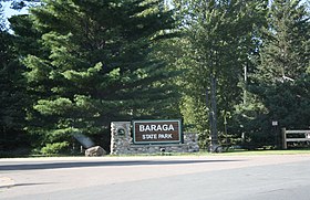
Baraga State Park
| Baraga State Park | |
|---|---|
 Entrance sign | |
| Location | Baraga Township Baraga County, Michigan |
| Nearest city | Baraga, Michigan |
| Coordinates | 46°45′54″N 88°30′03″W / 46.76500°N 88.50083°W [1] |
| Area | 56 acres (22.7 ha) |
| Elevation | 614 feet (187 m) [1] |
| Established | 1921 [2] |
| Governing body | Michigan Department of Natural Resources |
| Website | Baraga State Park |
Baraga State Park is a public recreation area covering 56 acres (23 ha) on the shore of Lake Superior's Keweenaw Bay in Baraga County, Michigan. The state park sits along Route 41 on the south side of the village of Baraga. The park, village, and county bear the name of Bishop Frederic Baraga.[3]
Activities and amenities
The park offers swimming, fishing, paddling, picnicking facilities, camping, nature trail, ungroomed cross-country skiing, snowmobiling, playground, and metal detecting.[3]
References
- ^ a b "Baraga State Park". Geographic Names Information System. United States Geological Survey, United States Department of the Interior.
- ^ "Baraga State Park" (PDF). Michigan Department of Natural Resources. April 2007. Retrieved February 9, 2018. "Established in 1921, the U.P.’s oldest State Park."
- ^ a b "Baraga State Park". Michigan Department of Natural Resources. Retrieved September 16, 2011.
External links
- Baraga State Park Michigan Department of Natural Resources
- Baraga State Park Map Mchigan Department of Natural Resources
- Baraga State Park Protected Planet

