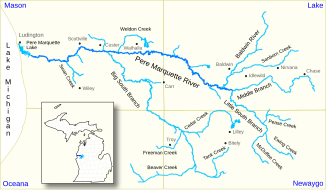
Pere Marquette River
| Pere Marquette River | ||
|
River system of the Pere Marquette River |
||
| Data | ||
| Water code | US : 1621211 | |
| location | Michigan (USA) | |
| River system | Saint Lawrence River | |
| Drain over | St. Clair River → Detroit River → Niagara River → Saint Lawrence River → Atlantic Ocean | |
| Association of |
Middle Branch and Little South Branch Pere Marquette River 43 ° 51 ′ 22 ″ N , 85 ° 50 ′ 30 ″ W. |
|
| Source height | 241 m | |
| muzzle |
Lake Michigan coordinates: 43 ° 57 ′ 6 " N , 86 ° 27 ′ 37" W 43 ° 57 ′ 6 " N , 86 ° 27 ′ 37" W. |
|
| Mouth height | 177 m | |
| Height difference | 64 m | |
| Bottom slope | 0.58 ‰ | |
| length | 111 km (including source rivers) | |
| Catchment area | 1955 km² | |
| Discharge at the Scottville A Eo gauge : 1763 km² |
MQ 1940/2016 Mq 1940/2016 |
20.5 m³ / s 11.6 l / (s km²) |
| Left tributaries | Big South Branch Pere Marquette River | |
| Flowing lakes | Pere Marquette Lake | |
| Small towns | Ludington | |
| Communities | Scottville | |
|
Paddlers on the Pere Marquette River |
||
The Pere Marquette River is a 111 km (including headwaters) long river in the US state of Michigan . It drains an area of 1955 km². The mean discharge at the USGS 04122500 gauge near Scottville is 20.5 m³ / s. The river was named after the French Jesuit and explorer Jacques Marquette .
course
The Pere Marquette River arises at the confluence of its two headwaters Middle Branch and Little South Branch Pere Marquette River south of the village of Baldwin. It flows in a predominantly westerly direction through the Manistee National Forest . The river has no dams or barrages. It passes the town of Scottville and reaches the estuary of Pere Marquette Lake , which is connected to Lake Michigan near the small town of Ludington .
nature and environment
A 106 km long stretch of the Pere Marquette River has the status of a National Wild and Scenic River and is classified as scenic . The protected stretch of water begins at the confluence of the Middle Branch and Little South Branch Pere Marquette Rivers and ends on US Highway 31 . The state of Michigan also classified the river as a Natural River and a Blue Ribbon Trout Stream . The river has larger populations of salmon and steelhead trout (the anadromous migratory form of rainbow trout).
Web links
Individual evidence
- ↑ Pere Marquette River in the United States Geological Survey's Geographic Names Information System
- ↑ a b c d The Pere Marquette River Watershed . River Restoration in Northern Michigan. Retrieved June 29, 2017.
- ↑ USGS 04122500 PERE MARQUETTE RIVER AT SCOTTVILLE, MI
- ↑ a b c d e Pere Marquette River . National Wild and Scenic Rivers System. Retrieved June 29, 2017.

