
Burmarsh: Difference between revisions
mNo edit summary |
Added demographics sections and cited everything |
||
| Line 23: | Line 23: | ||
In the 1870s Burmarsh was described by John Marius Wilson as: |
In the 1870s Burmarsh was described by John Marius Wilson as: |
||
<blockquote>"...a parish in Romney-Marsh district, Kent; on the coast, adjacent to the Military canal... Acres, 1,796. Real property, £4,612. Pop., 170. Houses, 32."<ref>{{Cite book|url=http://www.visionofbritain.org.uk/place/6155|title=Imperial Gazetter of England and Wales|last=Wilson|first=John Marius|publisher=A. Fullerton & Co.|year=1870{{ndash}}72|isbn=|location=Edinburgh|pages=|quote=|via=}}</ref></blockquote |
<blockquote>"...a parish in Romney-Marsh district, Kent; on the coast, adjacent to the Military canal... Acres, 1,796. Real property, £4,612. Pop., 170. Houses, 32."<ref>{{Cite book|url=http://www.visionofbritain.org.uk/place/6155|title=Imperial Gazetter of England and Wales|last=Wilson|first=John Marius|publisher=A. Fullerton & Co.|year=1870{{ndash}}72|isbn=|location=Edinburgh|pages=|quote=|via=}}</ref></blockquote> |
||
== History == |
== History == |
||
| Line 29: | Line 29: | ||
Burmarsh appears in the [[Domesday Book]] as both Borchemeres and Burwarmaresc. It was one of the very first known settlements on the [[Romney Marsh]]. During the reign of [[King Æthelwulf]], around the year 848, the King’s grandson, for the sum of four thousand pence, gave the manor of Burmarsh to his friend Wynemund, who gave it to the [[monastery of St. Augustine]]. After which it remained part of the possessions of the monastery, eventually being entered in the record of the Domesday book, under the general title of the land of the church of St. Augustine in Littlestone.<ref>{{Cite web|url=http://www.british-history.ac.uk/survey-kent/vol8/pp258-264#anchorn1|title=The History and Topographical Survey of the County of Kent: Volume 8|last=Bristow|first=W|date=|website=|archive-url=|archive-date=|dead-url=|access-date=}}</ref> When discovered by the Romans, they extracted salt from the area for use by the empire.<ref>{{Cite web|url=http://theromneymarsh.net/burmarsh|title=Romney Marsh, the Fifth Continent|last=|first=|date=|website=|archive-url=|archive-date=|dead-url=|access-date=}}</ref> |
Burmarsh appears in the [[Domesday Book]] as both Borchemeres and Burwarmaresc. It was one of the very first known settlements on the [[Romney Marsh]]. During the reign of [[King Æthelwulf]], around the year 848, the King’s grandson, for the sum of four thousand pence, gave the manor of Burmarsh to his friend Wynemund, who gave it to the [[monastery of St. Augustine]]. After which it remained part of the possessions of the monastery, eventually being entered in the record of the Domesday book, under the general title of the land of the church of St. Augustine in Littlestone.<ref>{{Cite web|url=http://www.british-history.ac.uk/survey-kent/vol8/pp258-264#anchorn1|title=The History and Topographical Survey of the County of Kent: Volume 8|last=Bristow|first=W|date=|website=|archive-url=|archive-date=|dead-url=|access-date=}}</ref> When discovered by the Romans, they extracted salt from the area for use by the empire.<ref>{{Cite web|url=http://theromneymarsh.net/burmarsh|title=Romney Marsh, the Fifth Continent|last=|first=|date=|website=|archive-url=|archive-date=|dead-url=|access-date=}}</ref> |
||
== Demographics == |
|||
[[File:Occupation Graphic.png|thumb|277x277px|Occupation of Population of Burmarsh, Kent as reported by the 1881 Census|left]]According to the 2011 Census there were 170 males and 160 females living in the parish.<ref>{{Cite web|url=http://www.neighbourhood.statistics.gov.uk/dissemination/LeadKeyFigures.do?a=7&b=11121440&c=Burmarsh&d=16&e=62&g=6438517&i=1001x1003x1032x1004&m=0&r=1&s=1486031865441&enc=1|title=Burmarsh (Parish): Key FIguers for 2011 Census: Key Statistics"|last=|first=|date=|website=Neighbourhood Statistics|publisher=|access-date=2 February 2017}}</ref> The 330 usual populace were spread out across an area of 1,724 hectares. This means the population density recorded was 0.2 hectares per person. <ref>{{Cite web|url=http://www.neighbourhood.statistics.gov.uk/dissemination/LeadTableView.do?a=7&b=11121440&c=Burmarsh&d=16&e=61&g=6438517&i=1001x1003x1032x1004&m=0&r=1&s=1491148085143&enc=1&dsFamilyId=2491|title=Population density 2011|last=|first=|date=|website=|archive-url=|archive-date=|dead-url=|access-date=}}</ref> Of the 330 people who permanently live in Burmarsh 246 of them are between 16-74. Of this figure 77 people had no qualifications which is equivalent to 28.5%.<ref>{{Cite web|url=http://www.neighbourhood.statistics.gov.uk/dissemination/LeadTableView.do?a=7&b=11121440&c=Burmarsh&d=16&e=62&g=6438517&i=1001x1003x1032x1004&m=0&r=1&s=1491148447643&enc=1&dsFamilyId=2536|title=Qualifications - Burmarsh|last=|first=|date=|website=|archive-url=|archive-date=|dead-url=|access-date=}}</ref> When compared to the national rate of 22.5%<ref>{{Cite web|url=https://www.surreyi.gov.uk/ViewPage1.aspx?C=resource&ResourceID=1266&cookieCheck=true&JScript=1#Qualification categories|title=UK percentage of people with no qualifications|last=|first=|date=|website=|archive-url=|archive-date=|dead-url=|access-date=}}</ref> we can see that Burmarsh is a little higher. There are still 167 usual residents employed<ref>{{Cite web|url=http://www.neighbourhood.statistics.gov.uk/dissemination/LeadTableView.do?a=7&b=11121440&c=Burmarsh&d=16&e=61&g=6438517&i=1001x1003x1032x1004&m=0&r=1&s=1491149160221&enc=1&dsFamilyId=2521|title=Total employment in Burmarsh|last=|first=|date=|website=|archive-url=|archive-date=|dead-url=|access-date=}}</ref>. This could suggest that the small, isolated nature of the parish may have something to do with a number of people working in jobs which require no qualifications. |
|||
== Church == |
== Church == |
||
| Line 43: | Line 46: | ||
==External links== |
==External links== |
||
* [http://www.theromneymarsh.net/villages/burmarsh.htm Burmarsh Website]{{Commons category inline|Burmarsh, Kent}}[[File:Burmarsh, Kent - Map Dating 1945.png|thumb|278x278px|Burmarsh Kent as seen in 1945]][[File:Burmarsh Kent Population Change over time.png|thumb|278x278px|Burmarsh - Population Change over time |
* [http://www.theromneymarsh.net/villages/burmarsh.htm Burmarsh Website]{{Commons category inline|Burmarsh, Kent}}[[File:Burmarsh, Kent - Map Dating 1945.png|thumb|278x278px|Burmarsh Kent as seen in 1945]][[File:Burmarsh Kent Population Change over time.png|thumb|278x278px|Burmarsh - Population Change over time]]{{Shepway}} |
||
[[Category:Villages in Kent]] |
[[Category:Villages in Kent]] |
||
Revision as of 16:11, 2 April 2017
| Burmarsh | |
|---|---|
 All Saints church | |
 Burmarsh Location within Kent | |
| Population | 330 [1] |
| District | |
| Shire county | |
| Region | |
| Country | England |
| Sovereign state | United Kingdom |
| Post town | Romney Marsh |
| Postcode district | TN29 |
| Police | Kent |
| Fire | Kent |
| Ambulance | South East Coast |
| UK Parliament | |
Burmarsh is a village[2] and civil parish in the Shepway District of Kent, England. The village is located three miles (4.8 km) west of Hythe on the Romney Marsh. The Burmarsh Road connects the village to the once fully operating Burmarsh Road train station.
In the 1870s Burmarsh was described by John Marius Wilson as:
"...a parish in Romney-Marsh district, Kent; on the coast, adjacent to the Military canal... Acres, 1,796. Real property, £4,612. Pop., 170. Houses, 32."[3]
History
The meaning of Burmarsh comes from Old English. Bur comes from "Burh-Ware" which equates to "Town Dwellers, and "Mersc" which means "Marsh". Therefore, if we collaborate these, Burmarsh means "Marsh of Town Dwellers".[4]
Burmarsh appears in the Domesday Book as both Borchemeres and Burwarmaresc. It was one of the very first known settlements on the Romney Marsh. During the reign of King Æthelwulf, around the year 848, the King’s grandson, for the sum of four thousand pence, gave the manor of Burmarsh to his friend Wynemund, who gave it to the monastery of St. Augustine. After which it remained part of the possessions of the monastery, eventually being entered in the record of the Domesday book, under the general title of the land of the church of St. Augustine in Littlestone.[5] When discovered by the Romans, they extracted salt from the area for use by the empire.[6]
Demographics

According to the 2011 Census there were 170 males and 160 females living in the parish.[7] The 330 usual populace were spread out across an area of 1,724 hectares. This means the population density recorded was 0.2 hectares per person. [8] Of the 330 people who permanently live in Burmarsh 246 of them are between 16-74. Of this figure 77 people had no qualifications which is equivalent to 28.5%.[9] When compared to the national rate of 22.5%[10] we can see that Burmarsh is a little higher. There are still 167 usual residents employed[11]. This could suggest that the small, isolated nature of the parish may have something to do with a number of people working in jobs which require no qualifications.
Church

The Burmarsh Parish Church is dedicated to the All Saints. The chapel was originally built in Saxon times but was extended into a church by monks of Canterbury during the Norman era, post the year 1066 (11th century). The church was expanded again in the 13th century. The west tower was built in the 15th century and the porch was then added in the 17th century. The interior was renovated in the late 19th century with the removal of the box pews, pulpit and the sound board.[12] The two of the three original bells at the church dating back to mediaeval times (the year 1375) and are still used to this day. The other bell is cracked and can now be seen on the floor of the church.[13]
Train Station

The Burmarsh Road railway station was opened on the 16th of July 1927, when it was called Burmarsh for East Dymchurch. The station had 2 platforms, a ticket office, waiting room and signaling facilities. [12]
Following the war the station was demoted to a 'halt', and renamed as Burmarsh Road Halt. It was closed down due to lack of use in 1948. The buildings were demolished, with exception of the roof of the waiting hall. In september 1977 the station was reopened to offer a school transport service to the Southlands Comprehensive School. [14] The school service last ran 2015.
References
- ^ "Parish population 2011". Retrieved 5 October 2015.
- ^ Burmarsh: The Fortress in the Marsh? Archived May 9, 2008, at the Wayback Machine
- ^ Wilson, John Marius (1870–72). Imperial Gazetter of England and Wales. Edinburgh: A. Fullerton & Co.
- ^ "History of Burmarsh". Kent Past.
{{cite web}}: Cite has empty unknown parameter:|dead-url=(help) - ^ Bristow, W. "The History and Topographical Survey of the County of Kent: Volume 8".
{{cite web}}: Cite has empty unknown parameter:|dead-url=(help) - ^ "Romney Marsh, the Fifth Continent".
{{cite web}}: Cite has empty unknown parameter:|dead-url=(help) - ^ "Burmarsh (Parish): Key FIguers for 2011 Census: Key Statistics"". Neighbourhood Statistics. Retrieved 2 February 2017.
- ^ "Population density 2011".
{{cite web}}: Cite has empty unknown parameter:|dead-url=(help) - ^ "Qualifications - Burmarsh".
{{cite web}}: Cite has empty unknown parameter:|dead-url=(help) - ^ categories "UK percentage of people with no qualifications".
{{cite web}}: Check|url=value (help); Cite has empty unknown parameter:|dead-url=(help) - ^ "Total employment in Burmarsh".
{{cite web}}: Cite has empty unknown parameter:|dead-url=(help) - ^ a b "Kent Past".
{{cite web}}: Cite has empty unknown parameter:|dead-url=(help) - ^ "All Saints Church, Burmarsh".
{{cite web}}: Cite has empty unknown parameter:|dead-url=(help) - ^ "Burmarsh Road railway station". Wikipedia. 2016-09-07.
External links
- Burmarsh Website
 Media related to Burmarsh, Kent at Wikimedia Commons
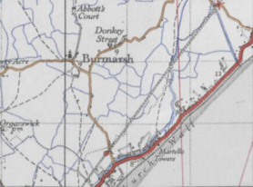
Burmarsh Kent as seen in 1945 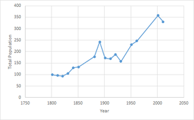
Burmarsh - Population Change over time

This Kent location article is a stub. You can help Wikipedia by expanding it.


