Romney Marsh
The Romney Marsh is a sparsely populated marshland in the counties of Kent and East Sussex in southeast England and about 260 km². The Romney Marsh is a unique area with a flat, open landscape.
The landscape of the Romney Marsh
The Romney Marsh consists of lowlands, partly below sea level. The landscape shows different characteristics:
- the actual Romney Marsh lies north of a line that runs from New Romney to Appledore .
- the Walland Marsh , lies south of this line to the border between Kent and East Sussex
- while the East Guldeford plane turn south to Rye spreads
- the Denge Marsh , located southeast of Lydd , and includes Denge Beach and the headland of Dungeness
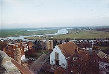
- the Rother plain lies, crossed by drainage ditches, around the former Isle of Oxney , which today forms a hill in the landscape. The town of Rye is located on a neighboring hill . Together with the towns of Pett and Winchelsea, this forms the centers of today's settlement in this part of the Romney Marsh.
The river Rother
The river Rother now flows into the bay at Rye; until 1287 its mouth was still between Romney and Lydd. The tides worked far upstream to Bodiam . The river delta was wide, a factor that made the city of Rye a port city. In front of the river delta was a large island, which today forms part of the Denge marshland in which the ports of the city of Lydd and Winchelsea are. The named port cities were members of the Cinque Port Association .
Reclamation of the landscape
The Romney Marsh landscape was formed by human hands over centuries.
The most momentous intervention in the reclamation of the marshland is the Rhee dam, which has a significant dam line. The English word Rhee is synonymous with the word river . Construction was carried out in 3 stages from Appledore to New Romney in the 13th century , with the river becoming a waterway.
The water level was controlled by locks, which at the same time had the task of flushing the silt out of the port of New Romney. The latter project failed, however, which is why the port silted up, with the result that New Romney lost its importance, while the Rhee took over part of the old port.
The rampart at Dymchurch was raised at the same time after storms broke through the pebble beach that had previously formed the protective line. According to a widespread misconception, the two walls mentioned were built by the Romans.
- In 1250 and in the following years, a series of violent storms broke over the protective gravel banks, with a considerable amount of land being flooded and turned back into marshland. The port of New Romney was destroyed and in 1287 the old port of Old Winchelsea was finally destroyed. Winchelsea, at that time the third largest port in England, through which most of the imported wine was discharged, was rebuilt in a higher position.
- In the 14th century, the land of the Walland and Denge marshlands was won by landfill.
- In 1462, the Romney Marsh Corporation was founded with the task of promoting drainage and building dams. These measures dragged on into the 16th century.
- In the 16th century, the course of the river Rother was corrected and directed into the canal, in which it still flows to this day, so that the last stretches of land from the sea could finally be wrested.
- The gravel deposits continued, which meant that today all the old ports of the cities of the Cinque-Port-Bund are no longer on the sea. In Dungeness , however, attempts are still being made to keep the original coastline by means of dredging.
The Romney sheep come from this marshland. They originated from long-haired sheep that were widespread here in the Middle Ages and are recognized as a separate breed after being crossed with English Leicester sheep around 1800.
history
The marshland belonged in the 9th century the priory of Canterbury , which it transferred from 1152 to 1167 a man who has survived as Baldwin in rent. He was given as much land as he could fence and drain himself . The term Baldwin's Sewer (Baldwin's drainage channels) is still in use today. Since then, the marshland has been criss-crossed by a dense network of drainage canals.
The medieval churches of the Romney Marsh
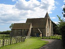
The Norman and early medieval churches shape the flat landscape, many of the 12 churches are open during the day and in most of them services are held (sometimes at least in turn) on Sundays. There are also 3 church ruins to visit.
All Saints in Lydd , the so-called cathedral of Romney Marsh , the Norman St. Nicholas Church in New Romney with late Gothic conversions and especially St. Augustine in Brookland , a cathedral that is known for its free-standing tower, the baptismal font and the Ornamentation is known. The representation of the 12 months and the 12 signs of the zodiac runs in a double arched frieze around a Norman baptismal font made of lead, which probably has no counterpart worldwide and comes from France. The nave from the 13th century is irregular: six arcades on one side face seven arcades on the other.
St Thomas Beckett's Church in Fairfield is rather remote and surrounded by pastureland. In the past, depending on the season, you could only get there on horseback or in a boat. The bricks are red and blue under a roof that has been pulled down. The interior of the church is characterized by box-like benches.
The church of St. George in Ivychurch is actually too big for the small town, it is said that part of the room was previously used to store smuggled goods.
The St. Augustine Church is located in Snave , which is no longer in use, but is framed by daffodils in spring and is worth seeing for that reason alone.
The church of St. Clement in Old Romney has a special color: the pews are painted in light pink, a pirate film was partly shot here in color. The white pews were optically too light, so the director had the pews painted.
British film director and artist Derek Jarman , who was born in Northwood , Middlesex in 1942 and died in 1994, is buried in the church cemetery.
literature
- John Piper: Romney Marsh. Penguin Books Ltd., London and New York 1950 ( King Penguin Books 55).
Coordinates: 51 ° 1 ′ 0 ″ N , 0 ° 55 ′ 0 ″ E


