
Cima di e Follicie
| Follicie | |
|---|---|
 View of the summit | |
| Highest point | |
| Prominence | 954 m (3,130 ft) |
| Isolation | 29.21 km (18.15 mi) |
| Coordinates | 42°49′41″N 9°23′09″E / 42.82806°N 9.38583°E |
| Geography | |
 Follicie | |
| Country | France |
| Department | Haute-Corse |
Cima di e Follicie is a mountain in the department of Haute-Corse on the island of Corsica, France. It is in the Monte Stello massif.
Location
The peak of Cima di e Follicie is just northeast of the interesection of the boundaries of the communes of Olcani to the south, Ogliastro to the west and Sisco to the east. It is southeast of the village of Canari and west of the town of Sisco.[1]
Physical
Cima di e Follicie has a prominence of 954 metres (3,130 ft) and an elevation of 1,322 metres (4,337 ft). It is isolated by 29.21 kilometres (18.15 mi) from Monte Asto to the south-southwest.[2] It is the highest peak in the Monte Stello massif, surpassing Monte Stello by 15 metres (49 ft).[3]
Hiking
It is the highest peak in Cap Corse. It looks over the Albo beach and Canelle point to the west and the sea around Sisco to the east. The hike from the village of Olcani climbs for almost 1,000 metres (3,300 ft). At first it follows a track that was meant to cross the cape but has never been paved, which climbs steeply at times to a small chapel in the San Giovanni pass, from where the track leads on to Sisco. A marked path leads towards the Pruberzulu rock, and from there to the summit.[4]
Gallery
-
 Cross on the "false summit"
 -
 Chapel of San Ghjuvà in Buca di San Ghjuvà
 -
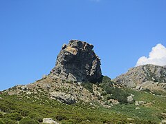 Pruberzulu rock on route up towards Cima di e Follicie
 -
 Monte Stello seen from Cima di e Follicie


Notes
Sources
- "Cima di e Follicie 1322m", Label-Rando (in French), retrieved 2021-12-09
- "Cima di e Follicie, France", Peakbagger, retrieved 2021-12-09
- "Les 7 massifs corses", Corse Location Villa (in French), retrieved 2021-12-09
- "Node: Cima di e Follicie (26862699)", OpenStreetMap, retrieved 2021-12-09
Landforms of the Haute-Corse department | ||
|---|---|---|
| Massifs |  | |
| Peaks | ||
| Passes | ||
| ||