
2009 cincy reds and Cheyenne County, Kansas: Difference between pages
shortcut/redirect |
m n' 60" -> n+1' 0" |
||
| Line 1: | Line 1: | ||
{{Infobox U.S. County| |
|||
#REDIRECT [[2009 Cincinnati Reds]] |
|||
county=Cheyenne County| |
|||
state=Kansas| |
|||
founded=[[March 20]], [[1873]]| |
|||
seat wl=St. Francis| |
|||
area_total_km2=2644|area_total_sq_mi=1021| |
|||
area_land_km2=2641|area_land_sq_mi=1020| |
|||
area_water_km2=2|area_water_sq_mi=1| |
|||
area percentage=0.09%| |
|||
census estimate yr=2006| |
|||
pop=2911| |
|||
density_km2=1.1|density_sq_mi=2.9| |
|||
time zone=Central| |
|||
UTC offset=-6| |
|||
DST offset=-5| |
|||
web=www.cheyennecounty.org}} |
|||
'''Cheyenne County''' (county code '''CN''') is a [[U.S. county|county]] located in Northwest [[Kansas]], in the [[Central United States|Central]] [[United States]]. The population was estimated to be 2,911 in the year 2006.<ref name="2006CoEst"/> Its [[county seat]] and most populous city is [[St. Francis, Kansas|St. Francis]].{{GR|6}} |
|||
==Law and government== |
|||
Following amendment to the [[Kansas Constitution]] in 1986, the county remained a prohibition, or [[dry county|"dry"]], county until 2000, when voters approved the sale of alcoholic liquor by the individual drink with a 30% food sales requirement.<ref>{{Cite web| url=http://www.ksrevenue.org/abcwetdrymap.htm| title=Map of Wet and Dry Counties| publisher=Alcoholic Beverage Control, Kansas Department of Revenue| month=November | year=2006| accessdate=2007-12-26}}</ref> |
|||
==Geography== |
|||
According to the [[U.S. Census Bureau]], the county has a total area of 1,021 square miles (2,644 km²), of which 1,020 square miles (2,641 km²) is land and 1 square miles (2 km²), or 0.09%, is water.{{GR|2}} |
|||
===Adjacent counties=== |
|||
*[[Dundy County, Nebraska|Dundy County]], [[Nebraska]] (north) |
|||
*[[Rawlins County, Kansas|Rawlins County]] (east) |
|||
*[[Sherman County, Kansas|Sherman County]] (south) |
|||
*[[Kit Carson County, Colorado|Kit Carson County]], [[Colorado]] (southwest) |
|||
*[[Yuma County, Colorado|Yuma County]], [[Colorado]] (west) |
|||
===Major highways=== |
|||
Sources: National Atlas<ref>[http://www.nationalatlas.gov/ National Atlas]</ref>, U.S. Census Bureau<ref>[http://www.census.gov/geo/www/tiger/ U.S. Census Bureau TIGER shape files]</ref> |
|||
* [[U.S. Route 36]] |
|||
* [[K-27 (Kansas highway)|Kansas Highway 27]] |
|||
* [[K-161 (Kansas highway)|Kansas Highway 161]] |
|||
==Demographics== |
|||
{{USCensusPop|1880=37|1890=4401|1900=2640|1910=4248|1920=5587|1930=6948|1940=6221|1950=5668|1960=4708|1970=4256|1980=3678|1990=3243|2000=3165}} |
|||
Cheyenne County's population was estimated to be 2,911 in the year 2006, a decrease of 247, or -7.8%, over the previous six years.<ref name="2006CoEst">{{Cite web| url=http://www.census.gov/popest/estimates.php| title=Population Estimates| publisher=U.S. Census Bureau, Population Division|}} Annual estimates of the population to [[2006-07-01]]. Released [[2007-03-22]]. Six year change is from [[2000-07-01]] to [[2006-07-01]].</ref> |
|||
As of the [[United States Census, 2000|U.S. Census in 2000]],{{GR|2}} there were 3,165 people, 1,360 households, and 919 families residing in the county. The [[population density]] was 3 people per square mile (1/km²). There were 1,636 housing units at an average density of 2 per square mile (1/km²). The [[Race (United States Census)|racial makeup]] of the county was 97.91% [[White American|White]], 0.13% [[Black American|Black]] or [[African American]], 0.09% [[Native Americans in the United States|Native American]], 0.32% [[Asian American|Asian]], 0.03% [[Pacific Islander American|Pacific Islander]], 0.98% from other races, and 0.54% from [[Multiracial|two or more races]]. [[Hispanic]] or [[Latino]] of any race were 2.59% of the population. |
|||
[[Image:USA Cheyenne County, Kansas age pyramid.svg|thumb|150px|left|[[Population pyramid]]]] |
|||
There were 1,360 [[household]]s out of which 27.60% had children under the age of 18 living with them, 60.10% were [[Marriage|married couples]] living together, 5.10% had a female householder with no husband present, and 32.40% were non-families. 30.80% of all households were made up of individuals and 17.30% had someone living alone who was 65 years of age or older. The average household size was 2.29 and the average family size was 2.85. |
|||
In the county the population was spread out with 23.80% under the age of 18, 5.10% from 18 to 24, 22.70% from 25 to 44, 21.80% from 45 to 64, and 26.60% who were 65 years of age or older. The median age was 44 years. For every 100 females there were 97.30 males. For every 100 females age 18 and over, there were 92.40 males. |
|||
The [[Median household income|median income for a household]] in the county was $30,599, and the median income for a family was $34,816. Males had a median income of $24,976 versus $19,569 for females. The [[per capita income]] for the county was $17,862. About 7.40% of families and 9.40% of the population were below the [[poverty line]], including 11.80% of those under age 18 and 6.70% of those age 65 or over. |
|||
== Cities and towns == |
|||
[[Image:Map of Cheyenne Co, Ks, USA.png|thumb|300px|Map of Cheyenne County ([[:Image:Kansas official transportation map legend.png|map legend]])]] |
|||
===Incorporated cities=== |
|||
Name and population (2004 estimate): |
|||
*[[St. Francis, Kansas|St. Francis]], 1,395 (county seat) |
|||
*[[Bird City, Kansas|Bird City]], 444 |
|||
===Unincorporated places=== |
|||
*Wheeler |
|||
==Townships== |
|||
Cheyenne County is divided into seven [[Civil township|townships]]. None of the cities within the county are considered ''governmentally independent'', and all figures for the township include those of the cities. In the following table, the population center is the largest city (or cities) included in that township's population total, if it is of a significant size. |
|||
{| class="wikitable" style="text-align:center; font-size:90%; margin-bottom:0.25em; clear:both;" |
|||
|- style="background:#ccccff" |
|||
! Township !! [[FIPS place code|FIPS]] !! Population<br>center |
|||
! Population !! Population<br>density<br><small>/km² (/sq mi)</small> |
|||
! Land area<br><small>km² (sq mi)</small> !! Water area<br><small>km² (sq mi)</small> !! Water % |
|||
! Geographic coordinates |
|||
|- |
|||
| Benkelman || 06025 || || 57 || 0 (1) || 186 (72) || 0 (0) || 0 % || {{coord|39|37|8|N|101|54|35|W|}} |
|||
|- |
|||
| Bird City || 06850 || [[Bird City, Kansas|Bird City]] || 771 || 1 (2) || 884 (341) || 0 (0) || 0.02% || {{coord|39|45|30|N|101|31|41|W|}} |
|||
|- |
|||
| Calhoun || 09950 || || 57 || 0 (1) || 231 (89) || 2 (1) || 0.70% || {{coord|39|56|8|N|101|39|18|W|}} |
|||
|- |
|||
| Cleveland Run || 14150 || || 67 || 0 (1) || 186 (72) || 0 (0) || 0.08% || {{coord|39|52|35|N|101|48|20|W|}} |
|||
|- |
|||
| Jaqua || 35025 || || 46 || 0 (1) || 124 (48) || 0 (0) || 0.01% || {{coord|39|39|48|N|102|1|20|W|}} |
|||
|- |
|||
| Orlando || 53050 || || 63 || 1 (2) || 93 (36) || 0 (0) || 0 % || {{coord|39|45|36|N|101|41|0|W|}} |
|||
|- |
|||
| Wano || 75375 || [[St. Francis, Kansas|St. Francis]] || 2,104 || 2 (6) || 937 (362) || 0 (0) || 0.05% || {{coord|39|45|27|N|101|50|4|W|}} |
|||
|- |
|||
|colspan=9|Sources: {{Cite web| url=http://www.census.gov/geo/www/gazetteer/places2k.html| title=Census 2000 U.S. Gazetteer Files| publisher=U.S. Census Bureau, Geography Division|}} |
|||
|} |
|||
== Education == |
|||
=== Unified school districts === |
|||
* Cheylin USD 103 |
|||
* St. Francis Schools USD 297 |
|||
==See also== |
|||
{{See also Kansas counties}} |
|||
==References== |
|||
<references/> |
|||
==External links== |
|||
'''Official sites''' |
|||
*[http://www.cheyennecounty.org/ Cheyenne County] |
|||
*[http://www.cheyennecountyhospital.com/ Cheyenne County Hospital] |
|||
'''Additional information''' |
|||
*[http://skyways.lib.ks.us/counties/CN/ Blue Skyways] |
|||
*[http://www.ku.edu/pri/ksdata/county.shtml Kansas Statistical Abstract] |
|||
{{Cheyenne County, Kansas}} |
|||
{{Kansas}} |
|||
[[Category:Kansas counties]] |
|||
[[Category:Cheyenne County, Kansas| ]] |
|||
[[ar:مقاطعة شايان، كانزاس]] |
|||
[[de:Cheyenne County (Kansas)]] |
|||
[[fr:Comté de Cheyenne (Kansas)]] |
|||
[[bpy:চেয়ান্নে কাউন্টি, ক্যানসাস]] |
|||
[[it:Contea di Cheyenne (Kansas)]] |
|||
[[nl:Cheyenne County (Kansas)]] |
|||
[[no:Cheyenne County (Kansas)]] |
|||
[[nds:Cheyenne County (Kansas)]] |
|||
[[pl:Hrabstwo Cheyenne (Kansas)]] |
|||
[[pt:Condado de Cheyenne]] |
|||
[[zh:夏延縣 (堪薩斯州)]] |
|||
Revision as of 20:57, 10 October 2008
Cheyenne County | |
|---|---|
 Location within the U.S. state of Kansas | |
 Kansas's location within the U.S. | |
| Coordinates: 39°48′N 101°48′W / 39.8°N 101.8°W | |
| Country | |
| State | |
| Founded | March 20, 1873 |
| Seat | St. Francis |
| Area | |
| • Total | 1,021 sq mi (2,644 km2) |
| • Land | 1,020 sq mi (2,641 km2) |
| • Water | 1 sq mi (2 km2) 0.09% |
| Population | |
| • Estimate (2006) | 2,911 |
| • Density | 2.9/sq mi (1.1/km2) |
| Time zone | UTC−6 (Central) |
| • Summer (DST) | UTC−5 (CDT) |
| Website | www |
Cheyenne County (county code CN) is a county located in Northwest Kansas, in the Central United States. The population was estimated to be 2,911 in the year 2006.[1] Its county seat and most populous city is St. Francis.Template:GR
Law and government
Following amendment to the Kansas Constitution in 1986, the county remained a prohibition, or "dry", county until 2000, when voters approved the sale of alcoholic liquor by the individual drink with a 30% food sales requirement.[2]
Geography
According to the U.S. Census Bureau, the county has a total area of 1,021 square miles (2,644 km²), of which 1,020 square miles (2,641 km²) is land and 1 square miles (2 km²), or 0.09%, is water.Template:GR
Adjacent counties
- Dundy County, Nebraska (north)
- Rawlins County (east)
- Sherman County (south)
- Kit Carson County, Colorado (southwest)
- Yuma County, Colorado (west)
Major highways
Sources: National Atlas[3], U.S. Census Bureau[4]
Demographics
| Census | Pop. | Note | %± |
|---|---|---|---|
| 1880 | 37 | — | |
| 1890 | 4,401 | 11,794.6% | |
| 1900 | 2,640 | −40.0% | |
| 1910 | 4,248 | 60.9% | |
| 1920 | 5,587 | 31.5% | |
| 1930 | 6,948 | 24.4% | |
| 1940 | 6,221 | −10.5% | |
| 1950 | 5,668 | −8.9% | |
| 1960 | 4,708 | −16.9% | |
| 1970 | 4,256 | −9.6% | |
| 1980 | 3,678 | −13.6% | |
| 1990 | 3,243 | −11.8% | |
| 2000 | 3,165 | −2.4% |
Cheyenne County's population was estimated to be 2,911 in the year 2006, a decrease of 247, or -7.8%, over the previous six years.[1]
As of the U.S. Census in 2000,Template:GR there were 3,165 people, 1,360 households, and 919 families residing in the county. The population density was 3 people per square mile (1/km²). There were 1,636 housing units at an average density of 2 per square mile (1/km²). The racial makeup of the county was 97.91% White, 0.13% Black or African American, 0.09% Native American, 0.32% Asian, 0.03% Pacific Islander, 0.98% from other races, and 0.54% from two or more races. Hispanic or Latino of any race were 2.59% of the population.

There were 1,360 households out of which 27.60% had children under the age of 18 living with them, 60.10% were married couples living together, 5.10% had a female householder with no husband present, and 32.40% were non-families. 30.80% of all households were made up of individuals and 17.30% had someone living alone who was 65 years of age or older. The average household size was 2.29 and the average family size was 2.85.
In the county the population was spread out with 23.80% under the age of 18, 5.10% from 18 to 24, 22.70% from 25 to 44, 21.80% from 45 to 64, and 26.60% who were 65 years of age or older. The median age was 44 years. For every 100 females there were 97.30 males. For every 100 females age 18 and over, there were 92.40 males.
The median income for a household in the county was $30,599, and the median income for a family was $34,816. Males had a median income of $24,976 versus $19,569 for females. The per capita income for the county was $17,862. About 7.40% of families and 9.40% of the population were below the poverty line, including 11.80% of those under age 18 and 6.70% of those age 65 or over.
Cities and towns

Incorporated cities
Name and population (2004 estimate):
- St. Francis, 1,395 (county seat)
- Bird City, 444
Unincorporated places
- Wheeler
Townships
Cheyenne County is divided into seven townships. None of the cities within the county are considered governmentally independent, and all figures for the township include those of the cities. In the following table, the population center is the largest city (or cities) included in that township's population total, if it is of a significant size.
| Township | FIPS | Population center |
Population | Population density /km² (/sq mi) |
Land area km² (sq mi) |
Water area km² (sq mi) |
Water % | Geographic coordinates |
|---|---|---|---|---|---|---|---|---|
| Benkelman | 06025 | 57 | 0 (1) | 186 (72) | 0 (0) | 0 % | 39°37′8″N 101°54′35″W / 39.61889°N 101.90972°W | |
| Bird City | 06850 | Bird City | 771 | 1 (2) | 884 (341) | 0 (0) | 0.02% | 39°45′30″N 101°31′41″W / 39.75833°N 101.52806°W |
| Calhoun | 09950 | 57 | 0 (1) | 231 (89) | 2 (1) | 0.70% | 39°56′8″N 101°39′18″W / 39.93556°N 101.65500°W | |
| Cleveland Run | 14150 | 67 | 0 (1) | 186 (72) | 0 (0) | 0.08% | 39°52′35″N 101°48′20″W / 39.87639°N 101.80556°W | |
| Jaqua | 35025 | 46 | 0 (1) | 124 (48) | 0 (0) | 0.01% | 39°39′48″N 102°1′20″W / 39.66333°N 102.02222°W | |
| Orlando | 53050 | 63 | 1 (2) | 93 (36) | 0 (0) | 0 % | 39°45′36″N 101°41′0″W / 39.76000°N 101.68333°W | |
| Wano | 75375 | St. Francis | 2,104 | 2 (6) | 937 (362) | 0 (0) | 0.05% | 39°45′27″N 101°50′4″W / 39.75750°N 101.83444°W |
Sources: "Census 2000 U.S. Gazetteer Files". U.S. Census Bureau, Geography Division. {{cite web}}: Cite has empty unknown parameter: |1= (help)
| ||||||||
Education
Unified school districts
- Cheylin USD 103
- St. Francis Schools USD 297
See also
- Community information for Kansas
- Kansas locations by per capita income
- List of counties in Kansas
- List of townships in Kansas
- List of cities in Kansas
- List of unincorporated communities in Kansas
- List of ghost towns in Kansas
References
- ^ a b "Population Estimates". U.S. Census Bureau, Population Division.
{{cite web}}: Cite has empty unknown parameter:|1=(help) Annual estimates of the population to 2006-07-01. Released 2007-03-22. Six year change is from 2000-07-01 to 2006-07-01. - ^ "Map of Wet and Dry Counties". Alcoholic Beverage Control, Kansas Department of Revenue. 2006. Retrieved 2007-12-26.
{{cite web}}: Unknown parameter|month=ignored (help) - ^ National Atlas
- ^ U.S. Census Bureau TIGER shape files
External links
Official sites
Additional information
Municipalities and communities of Cheyenne County, Kansas, United States | ||
|---|---|---|
| Cities | 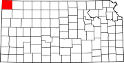 | |
| Unincorporated communities | ||
| Townships | ||