
Princes Town, Ghana: Difference between revisions
restructure, link |
m remove unused gallery link parameter, typo(s) fixed: Cannon ball → Cannonball |
||
| (45 intermediate revisions by 34 users not shown) | |||
| Line 1: | Line 1: | ||
{{Redirect|Prince's Town|the town in Trinidad|Princes Town}} |
{{Redirect|Prince's Town|the town in Trinidad|Princes Town}} |
||
{{Use Ghanaian English|date=January 2023}} |
|||
{{Use dmy dates|date=May 2019}} |
|||
{{Infobox settlement |
{{Infobox settlement |
||
<!--See the Table at Infobox Settlement for all fields and descriptions of usage--> |
<!--See the Table at Infobox Settlement for all fields and descriptions of usage--> |
||
<!-- Basic info ----------------> |
<!-- Basic info ----------------> |
||
| |
| name = Princes Town |
||
| native_name = Pokesu <!-- for cities whose native name is not in English --> |
|||
|other_name = |
|||
| |
| nickname = |
||
| image_skyline = Blick auf Princess Town.JPG |
|||
|nickname = |
|||
|settlement_type = |
| settlement_type = <!--For Town or Village (Leave blank for the default City)--> |
||
|motto = |
| motto = <!-- images and maps -----------> |
||
| pushpin_map = Ghana<!-- the name of a location map as per [[Template:Location map]] --> |
|||
<!-- images and maps -----------> |
|||
| pushpin_label_position = above |
|||
|image_skyline = |
|||
| pushpin_map_caption = Location of Princes Town in [[Western Region, Ghana|Western Region]] |
|||
|imagesize = 300px |
|||
|image_caption = |
|||
|image_flag = |
|||
|flag_size = |
|||
|image_seal = |
|||
|seal_size = |
|||
|image_shield = |
|||
|shield_size = |
|||
|image_blank_emblem = |
|||
|blank_emblem_type = |
|||
|blank_emblem_size = |
|||
|image_map = |
|||
|mapsize = |
|||
|map_caption = |
|||
|image_map1 = |
|||
|mapsize1 = |
|||
|map_caption1 = |
|||
|image_dot_map = |
|||
|dot_mapsize = |
|||
|dot_map_caption = |
|||
|dot_x = |dot_y = |
|||
|pushpin_map = Ghana<!-- the name of a location map as per http://en.wikipedia.org/wiki/Template:Location_map --> |
|||
|pushpin_label_position =above |
|||
|pushpin_map_caption =Location of Princes Town in [[Western Region (Ghana)|Western Region]] |
|||
<!-- Location ------------------> |
<!-- Location ------------------> |
||
| |
| subdivision_type = Country |
||
| |
| subdivision_name = [[Ghana]] |
||
| |
| subdivision_type1 = Region |
||
| |
| subdivision_name1 = [[Western Region, Ghana|Western Region]] |
||
| |
| subdivision_type2 = [[Districts of Ghana|District]] |
||
| |
| subdivision_name2 = [[Ahanta West District]] |
||
| area_blank1_sq_mi = |
|||
|subdivision_name2 = [[Ahanta West District]] |
|||
|subdivision_type3 = |
|||
|subdivision_name3 = |
|||
|subdivision_type4 = |
|||
|subdivision_name4 = |
|||
|government_footnotes = |
|||
|government_type = |
|||
|leader_title = |
|||
|leader_name = |
|||
|leader_title1 = <!-- for places with, say, both a mayor and a city manager --> |
|||
|leader_name1 = |
|||
|leader_title2 = |
|||
|leader_name2 = |
|||
|leader_title3 = |
|||
|leader_name3 = |
|||
|leader_title4 = |
|||
|leader_name4 = |
|||
|established_title = <!-- Settled --> |
|||
|established_date = |
|||
|established_title2 = <!-- Incorporated (town) --> |
|||
|established_date2 = |
|||
|established_title3 = <!-- Incorporated (city) --> |
|||
|established_date3 = |
|||
<!-- Area ---------------------> |
|||
|area_magnitude = |
|||
|unit_pref =Imperial <!--Enter: Imperial, if Imperial (metric) is desired--> |
|||
|area_footnotes = |
|||
|area_total_km2 = <!-- ALL fields dealing with a measurements are subject to automatic unit conversion--> |
|||
|area_land_km2 = <!--See table @ Template:Infobox Settlement for details on automatic unit conversion--> |
|||
|area_water_km2 = |
|||
|area_total_sq_mi = |
|||
|area_land_sq_mi = |
|||
|area_water_sq_mi = |
|||
|area_water_percent = |
|||
|area_urban_km2 = |
|||
|area_urban_sq_mi = |
|||
|area_metro_km2 = |
|||
|area_metro_sq_mi = |
|||
|area_blank1_title = |
|||
|area_blank1_km2 = |
|||
|area_blank1_sq_mi = |
|||
<!-- Population -----------------------> |
<!-- Population -----------------------> |
||
|population_as_of |
| population_as_of = 2012 |
||
|population_footnotes |
| population_footnotes = |
||
|population_note |
| population_note = |
||
|population_total |
| population_total = |
||
|population_density_km2 |
| population_density_km2 = |
||
|population_density_sq_mi |
| population_density_sq_mi = |
||
| population_density_urban_km2 = |
|||
|population_metro = |
|||
| population_density_urban_sq_mi = |
|||
|population_density_metro_km2 = |
|||
| population_blank1_title = Ethnicities |
|||
|population_density_metro_sq_mi = |
|||
| population_blank1 = |
|||
|population_urban = |
|||
| population_blank2_title = Religions |
|||
|population_density_urban_km2 = |
|||
population_blank2 = |
|||
|population_density_urban_sq_mi = |
|||
| population_density_blank1_sq_mi = |
|||
|population_blank1_title =Ethnicity |
|||
|population_blank1 =[[Akan people]] |
|||
|population_blank2_title =Religions |
|||
|population_blank2 = |
|||
|population_density_blank1_km2 = |
|||
|population_density_blank1_sq_mi = |
|||
<!-- General information ---------------> |
<!-- General information ---------------> |
||
| |
| timezone = [[Greenwich Mean Time|GMT]] |
||
| |
| utc_offset = |
||
| |
| timezone_DST = [[Greenwich Mean Time|GMT]] |
||
|utc_offset_DST = |
| utc_offset_DST = |
||
| coordinates = {{coord|4|47|37|N|2|8|5|W|region:GH|display=inline}} |
|||
|latd=4|latm=47 |lats=37|latNS=N |
|||
| elevation_footnotes = <!--for references: use ref tags--> |
|||
|longd=2|longm=8|longs=5 |longEW=W |
|||
| elevation_m = 0 |
|||
|elevation_footnotes = <!--for references: use <ref> </ref> tags--> |
|||
| |
| elevation_ft = |
||
|elevation_ft = |
|||
<!-- Area/postal codes & others --------> |
<!-- Area/postal codes & others --------> |
||
|postal_code_type = <!-- enter ZIP code, Postcode, Post code, Postal code... --> |
| postal_code_type = [[Ghana Post GPS]]<!-- enter ZIP code, Postcode, Post code, Postal code... --> |
||
|postal_code = |
| postal_code = WH-2286 |
||
| area_code = 03121<ref name="regcodes">{{cite web |title=REGIONAL DIALING CODES |url=https://vodafone.com.gh/help/regional-dialing-codes/ |website=vodafone.com.gh |publisher=Vodafone Ghana |access-date=20 July 2020}}</ref> |
|||
|area_code = |
|||
|blank_name = |
| blank_name = |
||
|blank_info = |
| blank_info = |
||
|blank1_name = |
| blank1_name = |
||
|blank1_info = |
| blank1_info = |
||
|website = |
| website = |
||
|footnotes = |
| footnotes = |
||
}} |
}} |
||
'''Princes Town''' or '''Pokesu''' is located 5 km east of [[Fort Santo Antonio|Fort St. Antonio]] on Manfro Hill in the [[Ahanta West District]] of the [[Western Region, Ghana|Western Region]] of south [[Ghana]], Africa. It lies between [[Axim]] to the west and [[Sekondi-Takoradi]] to the east. On 1 January 1681, a [[Brandenburg-Prussia|Brandenburger]] expedition of two ships commanded by [[Otto Friedrich von der Groeben]] arrived in the [[Brandenburger Gold Coast|Gold Coast]] and began to build a strong fort between Axim and the [[Cape of Three Points]]. The fort was completed in 1683 and was named Fort Fredericksburg (German: ''Groß Friedrichsburg, Groß-Friedrichsburg, Großfriedrichsburg'') in honour of Prince [[Frederick William I, Elector of Brandenburg]]. Because the fort was named after a Prince, it has been referred to as Princes Town. The fort was to be the headquarters of the Brandenburgers in Africa.<ref name="Princes Town-Ghana West Coast" /> |
|||
'''Princes Town''' is located 5 km east of Fort St. Antonio on Manfro Hill in the [[Ahanta West District]] of the [[Western Region (Ghana)|Western Region]] of [[Akanland]]. |
|||
==History== |
== History == |
||
By 1717, an [[Akan people|Akan]] [[merchant]], [[John Canoe]] learned that the Prussians were going to sell the fort to the Dutch. In protest, he began a resistance that managed to stave off fleets of [[battleship]]s for approximately seven years. The fort was eventually captured in 1724 or 1725 by the Dutch and renamed "Hollandia". Because John Canoe was successful in retaining control of the fort, inhabitants looked upon him as a hero.<ref name="Princes Town-Ghana West Coast" /> In 1872, the Dutch ceded the fort to Britain and in 1957, the fort became part of the newly independent country of Ghana.<ref name="Princes Town-Ghana West Coast">[http://www.ghanawestcoast.com/gwc/princess_town.php Princes Town-Ghana West Coast]. ''ghanawestcoast.com''.</ref> |
|||
===17th century=== |
|||
Princes Town lies between [[Axim]] to the west and [[Takoradi]] to the east. On 1 January 1681, a [[Brandenburg-Prussia|Brandenburger]] expedition of two ships commanded by [[Otto Friedrich von der Groeben]], arrived in the [[Brandenburger Gold Coast|Gold Coast]], and began to build a strong fort between Axim and the [[Cape of Three Points]]. The fort was completed in 1683 and was renamed Fort Gross-Friedrichsburg in honor of Prince [[Frederick William I, Elector of Brandenburg]]. Because the Fort was named after a Prince, it has been referred to as: Ft. Friedrichsburg/Princes Town. The fort was to be the headquarters of the Brandenburgers in Africa. |
|||
"[[Junkanoo]]" festivals, named after John Canoe, such as [[Mardi Gras]] are held annually in the coastal outlines of [[North Carolina]], in [[Jamaica]] and the [[Bahamas]]. |
|||
===18th century=== |
|||
In 1708, an [[Ahantan]] slave trader, Chief John Kanu (pronounced "Canoe") learned that the Germans were going to sell the Fort to the [[Netherlands|Dutch]]. In protest, he waged a war that managed to stave off fleets of battleships for almost 20 years. The Fort was eventually captured in 1725 by the Dutch and renamed Ft. Friedrichsburg to Ft. Hollandia. |
|||
== Fort Fredericksburg == |
|||
===19th and 20th century=== |
|||
[[File:Groß Friedrichsburg.JPG|thumb|Forts Groot Friedrichsburg]] |
|||
Because John Kanu was successful in retaining control of the Fort, slaves looked upon him as a hero. "[[Junkanoo]]" (pronounced "John Canoe") festivals such as [[Mardi Gras]] are held annually in the coastal outlines of [[North Carolina]], in [[Jamaica]] and the [[Bahamas]]. In 1872, the Dutch ceded the Fort to Britain and in 1957, the fort became part of Akanland. |
|||
The Fort Fredericksburg was built of stone transported by sea between 1681 and 1683 from [[Prussia]] and is one of two [[Germans|German]] forts built in Ghana, the other being [[Fort Dorothea]].<ref name="Briggs 2014 p. 257">{{cite book | last=Briggs | first=P. | title=Ghana | publisher=Bradt Travel Guides | series=Bradt Travel Guide Series | year=2014 | isbn=978-1-84162-478-5 | url=https://books.google.com/books?id=ShVTAgAAQBAJ&pg=PA257 | access-date=16 May 2019 | page=257}}</ref> It is estimated that some 300,000 Africans were transported through this fort. The remains of John Canoe are a mystery. Some{{Who|date=August 2020}} have said he was captured after having lost the battle of the fort while others have said his remains are in the Tafo Cemetery in [[Kumasi]]. Because of its testimony to the [[Atlantic slave trade]] and the history of European colonial trade and exploitation, the fort was inscribed on the [[UNESCO]] [[World Heritage List]] in 1979 along with [[List of castles in Ghana|several other castles and forts in Ghana]].<ref name="unesco">{{cite web|title=Forts and Castles, Volta, Greater Accra, Central and Western Regions|url=https://whc.unesco.org/en/list/34/|website=UNESCO World Heritage Convention|access-date=9 Oct 2022}}</ref> |
|||
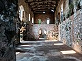
== Photo Gallery of Fort Fredericksburg == |
|||
The fort is built of stone transported by sea between 1681 and 1683 from [[Prussia]] and is the only known German fort ever built in Akanland. It is estimated that some 300,000 Africans were transported through this fort. The remains of John Kanu are a mystery. Some have said he was sold into slavery after having lost the battle of the fort while others have said his remains are in the Tafo Cemetery in [[Kumasi]]. |
|||
<gallery> |
|||
File:Fort Gross Fredericksburg 2.jpg|Fort Gross Fredericksburg at Princess town in the Western Region of Ghana |
|||
File:Fort Gross Fredericksburg 14.jpg|Fort Gross Fredericksburg at Princess town in the Western Region of Ghana |
|||
File:Fort Gross Fredericksburg 4.jpg|Fort Gross Fredericksburg at Princess town in the Western Region of Ghana |
|||
File:Fort Gross Fredericksburg 3.jpg|Fort Gross Fredericksburg at Princess town in the Western Region of Ghana |
|||
File:Fort Gross Fredericksburg 8.jpg|Cannonball in Fort Gross Fredericksburg at Princess town in the Western Region of Ghana |
|||
File:Fort Gross Fredericksburg 21.jpg|Part of the Fort Gross Fredericksburg at Princess town was damage as a result of battle in the fort. |
|||
File:Fort Gross Fredericksburg 11.jpg|Fort Gross Fredericksburg at Princess town in the Western Region of Ghana |
|||
File:Fort Gross Fredericksburg 19.jpg|Fort Gross Fredericksburg at Princess town in the Western Region of Ghana |
|||
File:Fort Gross Fredericksburg.jpg|Fort Gross Fredericksburg at Princess town in the Western Region of Ghana |
|||
File:Fort Gross Fredericksburg 15.jpg|Fort Gross Fredericksburg at Princess town in the Western Region of Ghana |
|||
File:Fort Gross Fredericksburg 17.jpg|Top of prison cell at Fort Gross Fredericksburg at Princess town in the Western Region of Ghana |
|||
</gallery> |
|||
== |
== Sister cities == |
||
The population of Princes Town is 5,200. Princes Town's gazetted Chief is Nana Ndama Kundumoah IV. |
|||
==Sister cities== |
|||
List of [[sister cities]] of Princes Town, designated by [[Sister Cities International]]: |
List of [[sister cities]] of Princes Town, designated by [[Sister Cities International]]: |
||
{| class="wikitable" |
{| class="wikitable" |
||
|- |
|- |
||
! style="background: |
! style='"background:'| |
||
! |
! style="height: 17px; background: width:120px;" | <span style="color:black;">Country</span> |
||
! style="background: |
! style='"background:'| |
||
! |
! style="background:width:110px;" | <span style="color:black;"> City</span> |
||
! style="background: |
! style='"background:'| |
||
! |
! style="background:width:130px;" | <span style="color:black;"> County / District / Region / State</span> |
||
! |
! style="background:width:40px;" | <span style="color:black;"> Date</span> |
||
|- |
|- |
||
| Colspan=1| {{flagicon|United States}} |
| Colspan=1 | {{flagicon|United States}} |
||
| Colspan=1| [[United States|USA]] |
| Colspan=1 | [[United States|USA]] |
||
| Colspan=1 |
| Colspan=1 | |
||
| Colspan=1| '''[[Fredericksburg, Virginia|Fredericksburg, VA]]''' |
| Colspan=1 | '''[[Fredericksburg, Virginia|Fredericksburg, VA]]''' |
||
| Colspan=1| [[File:Flag of Virginia.svg|25px]] |
| Colspan=1 | [[File:Flag of Virginia.svg|25px]] |
||
| Colspan=1| ''[[Virginia]]'' |
| Colspan=1 | ''[[Virginia]]'' |
||
| Colspan=1| |
| Colspan=1 | |
||
|} |
|} |
||
== References == |
|||
==Sources and external links== |
|||
{{reflist}} |
|||
*[http://www.fredericksburgsistercity.org Fredericksburg-Princes Town Sister City Association, Inc.] |
|||
== External links == |
|||
* [https://web.archive.org/web/20070621144003/http://www.fredericksburgsistercity.org/ Fredericksburg-Princes Town Sister City Association, Inc.] |
|||
{{Gold Coast}} |
|||
{{Western Region, Ghana}}{{-}} |
|||
{{Akanland-geo-stub}} |
|||
{{coord|04|47|37|N|02|08|05|W|display=title}} |
{{coord|04|47|37|N|02|08|05|W|display=title}} |
||
{{Authority control}} |
|||
[[Category: |
[[Category:Populated places in Ahanta West Municipal District]] |
||
[[Category:Populated places in the Western Region (Ghana)]] |
|||
[[pl:Princes Town (Ghana)]] |
|||
Latest revision as of 20:36, 10 January 2024
Princes Town
Pokesu | |
|---|---|
 | |
 Princes Town Location of Princes Town in Western Region | |
| Coordinates: 4°47′37″N 2°8′5″W / 4.79361°N 2.13472°W | |
| Country | Ghana |
| Region | Western Region |
| District | Ahanta West District |
| Elevation | 0 m (0 ft) |
| Time zone | GMT |
| • Summer (DST) | GMT |
| Ghana Post GPS | WH-2286 |
| Area code | 03121[1] |
Princes Town or Pokesu is located 5 km east of Fort St. Antonio on Manfro Hill in the Ahanta West District of the Western Region of south Ghana, Africa. It lies between Axim to the west and Sekondi-Takoradi to the east. On 1 January 1681, a Brandenburger expedition of two ships commanded by Otto Friedrich von der Groeben arrived in the Gold Coast and began to build a strong fort between Axim and the Cape of Three Points. The fort was completed in 1683 and was named Fort Fredericksburg (German: Groß Friedrichsburg, Groß-Friedrichsburg, Großfriedrichsburg) in honour of Prince Frederick William I, Elector of Brandenburg. Because the fort was named after a Prince, it has been referred to as Princes Town. The fort was to be the headquarters of the Brandenburgers in Africa.[2]
History[edit]
By 1717, an Akan merchant, John Canoe learned that the Prussians were going to sell the fort to the Dutch. In protest, he began a resistance that managed to stave off fleets of battleships for approximately seven years. The fort was eventually captured in 1724 or 1725 by the Dutch and renamed "Hollandia". Because John Canoe was successful in retaining control of the fort, inhabitants looked upon him as a hero.[2] In 1872, the Dutch ceded the fort to Britain and in 1957, the fort became part of the newly independent country of Ghana.[2]
"Junkanoo" festivals, named after John Canoe, such as Mardi Gras are held annually in the coastal outlines of North Carolina, in Jamaica and the Bahamas.
Fort Fredericksburg[edit]

The Fort Fredericksburg was built of stone transported by sea between 1681 and 1683 from Prussia and is one of two German forts built in Ghana, the other being Fort Dorothea.[3] It is estimated that some 300,000 Africans were transported through this fort. The remains of John Canoe are a mystery. Some[who?] have said he was captured after having lost the battle of the fort while others have said his remains are in the Tafo Cemetery in Kumasi. Because of its testimony to the Atlantic slave trade and the history of European colonial trade and exploitation, the fort was inscribed on the UNESCO World Heritage List in 1979 along with several other castles and forts in Ghana.[4]
Photo Gallery of Fort Fredericksburg[edit]
-
 Fort Gross Fredericksburg at Princess town in the Western Region of Ghana
 -
 Fort Gross Fredericksburg at Princess town in the Western Region of Ghana
 -
 Fort Gross Fredericksburg at Princess town in the Western Region of Ghana
 -
 Fort Gross Fredericksburg at Princess town in the Western Region of Ghana
 -
 Cannonball in Fort Gross Fredericksburg at Princess town in the Western Region of Ghana
 -
 Part of the Fort Gross Fredericksburg at Princess town was damage as a result of battle in the fort.
 -
 Fort Gross Fredericksburg at Princess town in the Western Region of Ghana
 -
 Fort Gross Fredericksburg at Princess town in the Western Region of Ghana
 -
 Fort Gross Fredericksburg at Princess town in the Western Region of Ghana
 -
 Fort Gross Fredericksburg at Princess town in the Western Region of Ghana
 -
 Top of prison cell at Fort Gross Fredericksburg at Princess town in the Western Region of Ghana


Sister cities[edit]
List of sister cities of Princes Town, designated by Sister Cities International:
| Country | City | County / District / Region / State | Date | |||
|---|---|---|---|---|---|---|
| USA | Fredericksburg, VA | Virginia |
References[edit]
- ^ "REGIONAL DIALING CODES". vodafone.com.gh. Vodafone Ghana. Retrieved 20 July 2020.
- ^ a b c Princes Town-Ghana West Coast. ghanawestcoast.com.
- ^ Briggs, P. (2014). Ghana. Bradt Travel Guide Series. Bradt Travel Guides. p. 257. ISBN 978-1-84162-478-5. Retrieved 16 May 2019.
- ^ "Forts and Castles, Volta, Greater Accra, Central and Western Regions". UNESCO World Heritage Convention. Retrieved 9 October 2022.