Rokovci: Difference between revisions
Content deleted Content added
m v2.05 - Fix errors for CW project (Reference list missing) |
No edit summary |
||
| Line 4: | Line 4: | ||
| other_name = |
| other_name = |
||
| settlement_type = [[Settlement (Croatia)|Village]] ([[village#Slavic countries|Selo]]) |
| settlement_type = [[Settlement (Croatia)|Village]] ([[village#Slavic countries|Selo]]) |
||
| image_skyline = |
| image_skyline = {{Photomontage|position=center |
||
|photo1a =Rokovci - Роковци.jpg |
|||
|photo1b =Rokovci - Роковци 01.jpg |
|||
|photo2a =Rokovačke zidine - Роковачке зидине.jpg |
|||
|photo2b =Rokovci - Роковци 02.jpg |
|||
|size = 270 |
|||
|spacing = 1 |
|||
|color = #FFFFFF |
|||
|border = 1 |
|||
}} |
|||
| imagesize = |
| imagesize = |
||
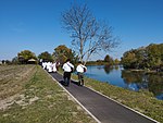
| image_caption = Rokovci from the [[Bosut river]] |
| image_caption = Rokovci from the [[Bosut river]] & Rokovci fortification |
||
| image_flag = |
| image_flag = |
||
| flag_size = |
| flag_size = |
||
Latest revision as of 16:54, 5 April 2024
Rokovci | |
|---|---|
Rokovci from the Bosut river & Rokovci fortification | |
 | |
| Country | |
| County | |
| Municipality | Andrijaševci |
| Area | |
| • Total | 5.8 sq mi (15.0 km2) |
| Population (2021)[2] | |
| • Total | 1,692 |
| • Density | 290/sq mi (110/km2) |
| Time zone | UTC+1 (CET) |
| • Summer (DST) | UTC+2 (CEST) |
Rokovci (Hungarian: Rokovce) is a village in eastern Croatia in the Andrijaševci Municipality of Vukovar-Syrmia County.
Name[edit]
The name of the village in Croatian is plural.
See also[edit]
References[edit]
- ^ Register of spatial units of the State Geodetic Administration of the Republic of Croatia. Wikidata Q119585703.
- ^ "Population by Age and Sex, by Settlements, 2021 Census". Census of Population, Households and Dwellings in 2021. Zagreb: Croatian Bureau of Statistics. 2022.


