
Waarder
Waarder | |
|---|---|
Village | |
 Waarder with the church and the medieval Kerkelaantje | |
 Waarder Location in the province of South Holland in the Netherlands  Waarder Location in the Netherlands | |
| Coordinates: 52°3′41″N 4°49′21″E / 52.06139°N 4.82250°E | |
| Country | Netherlands |
| Province | South Holland |
| Municipality | Bodegraven-Reeuwijk |
| Area | |
| • Total | 8.56 km2 (3.31 sq mi) |
| Elevation | −1.6 m (−5.2 ft) |
| Population (2021)[1] | |
| • Total | 1,660 |
| • Density | 190/km2 (500/sq mi) |
| Time zone | UTC+1 (CET) |
| • Summer (DST) | UTC+2 (CEST) |
| Postal code | 3466[1] |
| Dialing code | 0348 |
Waarder is a village in the Dutch province of South Holland. It is a part of the former municipality of Reeuwijk, and lies about 5 km southwest of Woerden.
The village was first mentioned in 1108 as Werdere and means "(river) island".[3] Waarder developed as a road on a silted river arm in the 12th century. The Dutch Reformed church is a single aisled cruciform church from the 16th century.[4]
Waarder was a separate municipality until 1964, when it became part of Driebruggen,[5] which became part of Reeuwijk in 1989. Since 2011 it is part of the municipality of Bodegraven-Reeuwijk.[6]
Gallery[edit]
-
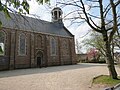 Dutch Reformed church
 -
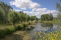 Nature near Waarder


References[edit]
- ^ a b c "Kerncijfers wijken en buurten 2021". Central Bureau of Statistics. Retrieved 3 May 2022.
- ^ "Postcodetool for 3466LA". Actueel Hoogtebestand Nederland (in Dutch). Het Waterschapshuis. 24 July 2019. Retrieved 3 May 2022.
- ^ "Waarder - (geografische naam)". Etymologiebank (in Dutch). Retrieved 3 May 2022.
- ^ Ronald Stenvert & Sabine Broekhoven (2004). "Waarder" (in Dutch). Zwolle: Waanders. ISBN 90-400-9034-3. Retrieved 3 May 2022.
- ^ Ad van der Meer and Onno Boonstra, Repertorium van Nederlandse gemeenten, KNAW, 2011.
- ^ "Waarder". Plaatsengids (in Dutch). Retrieved 3 May 2022.
This South Holland location article is a stub. You can help Wikipedia by expanding it. |