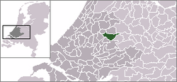
Reeuwijk
 flag |
 coat of arms |
| province |
|
| local community |
|
|
Area - land - water |
50.11 km 2 38.24 km 2 11.87 km 2 |
| Residents | 13,296 (Dec. 31, 2010) |
| Coordinates | 52 ° 3 ' N , 4 ° 43' E |
| Important traffic route |
|
| prefix | 0182, 0348 |
| Postcodes | 2411, 2741, 2771, 2801, 2804-2805, 2807, 2811 |
Reeuwijk ( ) is a former municipality in South Holland . Since January 1, 2011 it has been part of the Bodegraven-Reeuwijk municipality .
The following cities and villages also belong to the administrative area of the municipality of Reeuwijk: Driebruggen , Hogebrug , Sluipwijk , Tempel, Waarder .
politics
Distribution of seats in the municipal council
| Political party | Seats | |||
|---|---|---|---|---|
| 1994 | 1998 | 2002 | 2006 | |
| VVD | 3 | 4th | 4th | 3 |
| CDA | 3 | 3 | 3 | 3 |
| ChristenUnie / SGP | - | - | 3 | 3 |
| Reeuwijk's concern | 4th | 2 | 3 | 3 |
| PvdA / GroenLinks | 2 | 2 | 1 | 3 |
| D66 | 1 | 1 | 1 | - |
| SGP / RPF | 2 | 3 | - | - |
| total | 15th | 15th | 15th | 15th |
Personalities
- Joop Zijlaard (* 1943), Derny pacemaker and restaurateur
Web links
Commons : Reeuwijk - collection of images, videos and audio files
Individual evidence
- ↑ Bevolkingsontwikkeling; regio per maand Centraal Bureau voor de Statistiek , accessed on May 21, 2018 (Dutch)
- ↑ Allocation of seats in the municipal council: 1994–2002 2006 , accessed on May 21, 2018 (Dutch)
