
Central railway station, Brisbane
Central railway station is, as the name suggests, the central railway station for the QR Citytrain network in the Brisbane central business district, the state capital of Queensland, Australia. A major interchange for train services on the network, Central is located in Zone 1 of the TransLink integrated public transport system.
History
The first building for Central railway station was a structure of wood and corrugated galvanised iron, and opened on 18 August 1889 as a terminus of the line after Roma Street railway station.[1]
In 1891[2] the tunnel to Brunswick Street railway station was opened so trains could run directly from Central to northern destinations. An elegant new station was constructed and opened in 1899[2] with arches of corrugated galvanised iron over the platforms and a portico on Ann Street. Both of these features were sacrificed to progress when the Sheraton Hotel (now Sofitel Brisbane) was built over the station and Ann Street was widened.
In 1904, Central had the only electro-pneumatic system in Australia for changing points and signals.
In 1996, four new tunnels were constructed between Central and Brunswick Street and Roma Street stations, with two new platforms added to Central to increase capacity, especially with new services commencing on the rebuilt Gold Coast line.[3]
Station configuration
Central railway station is located at the northern end of the Brisbane central business district on Ann Street, directly opposite ANZAC Square. Pedestrian access is available from the main entrance at the corner of Ann and Edward Streets, or the pedestrian subway connecting ANZAC Square with Upper Edward Street.
There is elevator access to Central Station from Ann Street opposite the Shrine of Remembrance, and from Wickham Terrace on the northern corner of the complex. There are also escalators to Central Station from ANZAC Square Arcade, next to ANZAC Square.
The Central Station complex houses a McDonald's restaurant, newsagent, cafes, a men's hairdresser, and a QR Travel Centre.
Services by platform
Central railway station serves all suburban and interurban lines. The platforms at Central are numbered from 1 to 6, with 1 being the easternmost platform and 6 the westernmost. Services typically use platforms in a predictable fashion, however during peak periods, some services may use different platforms from those listed below:
- * Express trains operate on this line during peak periods
- + Trains only operate during peak periods only, a railbus operates at other times
- ^ Limited direct services to Rosewood, most services require a change of trains at Ipswich
Connecting lines
The table below shows the railway lines that a train may connect to at Central railway station. However some trains, especially during peak periods, may connect to different lines than those shown on the box below; a train may run from Ferny Grove to Cleveland, for example.
| North | South/West | |
|---|---|---|
| Caboolture line Shorncliffe line |
↔ | Ipswich line |
| Ferny Grove line | ↔ | Beenleigh line Corinda via South Brisbane line |
| Airport line | ↔ | Gold Coast line |
| Doomben line | ↔ | Cleveland line |
Gallery
-
 A Suburban Multiple Unit on platform 3
 -
 Central station, off Ann Street, combines elements of the 1899 building with later extensions
 -
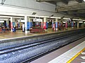 Looking towards platforms 4 to 1
 -
 Clock tower entrance on Ann Street
 -
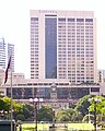 Sofitel Brisbane atop Central
 -
 Wickham Terrace entrance


References
- ^ "Central Railway Station - EPA/QPWS". Queensland Government. 2006. Retrieved 2007-07-27.
- ^ a b Hallam, Greg (2005). Brisbane's Biography (Steamtrain Sunday). QR Limited.
- ^ "Future rail connection in study's sights" (Press release). Government of Queensland. 26 August 2007. Retrieved 2008-02-13.
{{cite press release}}: Check date values in:|date=(help)
External links
Template:CitytrainBrisbane/Navigation begin Template:CitytrainBrisbane/Navigation Template:CitytrainBrisbane/Navigation Template:CitytrainBrisbane/Navigation Template:CitytrainBrisbane/Navigation Template:CitytrainBrisbane/Navigation Template:CitytrainBrisbane/Navigation Template:CitytrainBrisbane/Navigation Template:CitytrainQld/Navigation Template:CitytrainBrisbane/Navigation Template:CitytrainQld/Navigation Template:CitytrainBrisbane/Navigation Template:CitytrainBrisbane/Navigation Template:CitytrainBrisbane/Navigation end