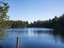
Étang de la Gruère
| Étang de la Gruère | ||
|---|---|---|

|
||
| Étang de la Gruère | ||
| Geographical location | Canton of Jura | |
| Data | ||
| Coordinates | 570 322 / 232071 | |
|
|
||
| Altitude above sea level | 998 m above sea level M. | |
The Étang de la Gruère is a dammed moor lake that is located in a hollow on the high plateau of the Freiberg Mountains in the Swiss canton of Jura .
location
The moor lake is 998 m above sea level. M. on the parish grounds of Saignelégier , about halfway between Saignelégier and Tramelan . It is 600 m long, at least 60 m wide and around 4.5 m deep. The nature reserve Étang de la Gruère covers an area of approximately 1 km² with the forest area around the actual lake and two other small moor ponds northeast of it.
geology
The high moor of the Étang de la Gruère lies on the porous limestone subsoil of the Freiberg mountains. Glacial erosion during the ice ages and fluvial erosion eroded the surrounding peaks and ridges over time, and hollows were lined with layers of marl and clay , which sealed the permeable subsoil. A raised bog developed on these impermeable layers in the Holocene .
Today the peat layer around the Étang de la Gruère is about 6 to 8 m thick. The lowest peat layers are between 12,000 and 15,000 years old. The climate and forest history of the region can be reconstructed using the pollen that is preserved in the peat.
history
In this bog containing earlier a pond, the was in the 50s the 17th century, the Etang de la Gruère dammed by an earth dam. At that time it was supposed to serve as a collecting basin for the operation of a mill, so that there was enough water power available even in periods of low rainfall. The mill was later replaced by a sawmill.
The lake water shows the typical brown color of moorland with fine peat residues and humus matter. The water flowing out of the Étang de la Gruère only remains on the surface for around 200 m, then it disappears in a deep throat and only reappears in the Tramelan basin.
vegetation
The high moor zone has a unique vegetation with peat moss , cranberries and bog berries , blueberry bushes and rosemary heather . The adjacent forests consist mainly of spruce , mountain pine , moor birch and dwarf birch . In 1963 the area of the Étang de la Gruère was placed under nature protection. Today a nature trail leads around the moor lake.
Web links
- Étang de la Gruère
- Étang de la Gruère on the ETHorama platform

