Ísafjörður (fjord)
| Ísafjörður | ||
|---|---|---|
|
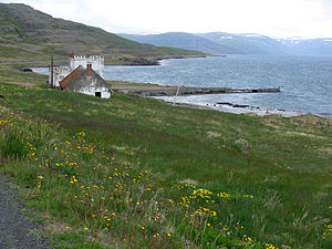
The abandoned Arngerðareyri estate from 1800 in Ísafjörður |
||
| Waters | Ísafjarðardjúp | |
| Land mass | Iceland | |
| Geographical location | 65 ° 52 ′ N , 22 ° 26 ′ W | |
|
|
||
| width | 3 km | |
| length | 25 km | |
| Tributaries | Ísafjarðará | |
The Ísafjörður is a fjord in the Westfjords of Iceland .
This fjord is the innermost and easternmost in Ísafjarðardjúp . It extends 25 km into the country and is about 3 km wide. In front of the fjord is the island of Borgarey . The paved Djúpvegur (road 61) runs around the entire fjord for a distance of about 37 km. On the east bank, the highland road branches off ![]() over the Kollafjarðarheiði . It leads south into the Kollafjörður . The path around the neighboring western fjord Mjóifjörður was shortened in 2009 by a bridge. Before that, the Mjóafjarðarvegur (road 633) led from the interior of the fjord over a pass at Eyrarfjall. This street is no longer maintained.
over the Kollafjarðarheiði . It leads south into the Kollafjörður . The path around the neighboring western fjord Mjóifjörður was shortened in 2009 by a bridge. Before that, the Mjóafjarðarvegur (road 633) led from the interior of the fjord over a pass at Eyrarfjall. This street is no longer maintained.
The well-known town of Ísafjörður is 40 km as the crow flies northwest in Skutulsfjörður .
Individual evidence
- ↑ Brúaskrá - bryr á þjóðvegum. Retrieved April 4, 2019 (Icelandic).

