Ísafjarðardjúp
| Ísafjarðardjúp | ||
|---|---|---|
|
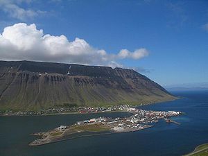
The town of Ísafjörður on Skútulsfjörður, on the right a view of Ísafjarðardjúp and Hornstrandir |
||
| Waters | Atlantic Ocean | |
| Land mass | Iceland | |
| Geographical location | 66 ° 5 ′ N , 22 ° 50 ′ W | |
|
|
||
| length | approx. 75 km | |
| Islands | Vigur , Æðey , Borgarey | |
The Ísafjarðardjúp ( German "Eisfjordtiefe") is the largest fjord in the Icelandic region of Vestfirðir .
It cuts about 75 km inland and branches off into many side fjords. With the extension of the Ísafjörður fjord into which it merges, it measures approx. 120 km.
There are some islands in the fjord. The largest are Vigur , Æðey (near Snæfjallaströnd ) and Borgarey (in the Ísafjörður fjord). In the north of Ísafjarðardjúp are the lonely and completely uninhabited Hornstrandir peninsula , a popular hiking area, and Snæfjallaströnd, where there is snow all year round (below the Drangajökull glacier , approx. 620 km²).
Kaldalón , a small fjord named after a doctor and composer in the area, almost reaches one of the glacier tongues, and you can hike there.
Numerous rather long side fjords (up to approx. 30 km) branch off mainly to the south:
The branches of Ísafjarðardjúp
The details are as follows (starting clockwise in the northwest):
- Kaldalón (Eng. "Cold Lagoon")
- Ísafjörður (Eng. "Icefjord")
- Reykjarfjörður (Eng. "Smoke Fjord")
- Vatnsfjörður (Eng. "Waterfjord")
- Mjóifjörður (Eng. "Narrow Fjord")
- Skötufjörður (Eng. "Rochenfjord")
- Hestfjörður (German "horse fjord")
- Seyðisfjörður (Eng. "Sheep Fjord")
- Álftafjörður (Eng. "Schwanenfjord")
- Skutulsfjörður (Eng. "Harpunenfjord"), on a peninsula in it lies the city of Ísafjörður
- Bolungarvík (Eng. "Woodpile Bay")


