
Île d'Orléans
| Île d'Orléans | ||
|---|---|---|
 |
||
| Waters | Saint Lawrence River | |
| Geographical location | 46 ° 54 ′ N , 71 ° 0 ′ W | |
|
||
| length | 34 km | |
| width | 8 kilometers | |
| surface | 191.78 km² | |
| Highest elevation | 151 m | |
| Residents | 7000 37 inhabitants / km² |
|
| main place | Saint-Pierre-de-l'Île-d'Orléans | |
 |
||

The Île d'Orléans is an island in the southeast of the Canadian province of Québec . It is located at the mouth of the Saint Lawrence River , about five kilometers northeast of the provincial capital Québec . It is the second largest island in the river after the Île de Montréal .
geography
The 191.78 km² island is around 34 km long and eight kilometers wide. While the coast of the island slopes down relatively steeply, the interior consists of a consistently flat plain, the central part of which is forested. The soil is fertile and is used intensively for agriculture. The highest point at 151 meters is in the south of the island. At the northern tip there is an extensive mudflat .
There are six municipalities on the island with a total of around 7,000 inhabitants, which together form the regional county municipality of L'Île-d'Orléans . The Pont de l'île d'Orléans , a suspension bridge with a total length of 4.43 km, connects to the city of Québec. Opposite the southern tip is the Montmorency Falls .
history
The Hurons originally called the island Minigo . The French researcher Jacques Cartier first reached it in 1535 and named it Île de Bacchus because of the many wild vines there . But on May 6, 1536 he renamed it Île d'Orléans , in honor of the Duke of Orléans , son of King Francis I.
Because of its favorable location, the Île d'Orléans was one of the first regions of Québec from 1636 to be settled by French colonists (mainly from Normandy and Poitou ). After the first settlers were killed in an attack by the Iroquois in 1656 , resettlement began in 1660.
In 1759 the island was occupied and sacked by British troops, only three of the 350 farms remained intact. Before the battle of the Plains of Abraham, these served as the starting point for General James Wolfe's conquest of Québec . Since 1935 the island has been connected to the mainland by a suspension bridge; previously there was only one ferry.
Today the economy is mainly based on agriculture (wheat and corn cultivation, viticulture , cider production, animal husbandry). Tourism also plays an important role ; many Quebec City residents own weekend cottages on the island or go sailing.
photos

View of the northern arm of St. Lawrence
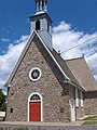
Saint-Pierre Church (built 1717)

Saint-Laurent marina
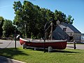
Boat museum in Saint-Laurent

The Île d'Orléans with the Pont de l'Île d'Orléans in the background

.jpg)
.jpg)
.jpg)

literature
Walther Tuckermann: The Île d'Orléans in the Lorenz Current. One of the oldest settlement centers in French Canada. In: Koloniale Rundschau, 27. Bibliographical Institute , Leipzig 1936, pp. 123–135
Web links
- Regional county town of L'Île-d'Orléans
- Île d'Orléans Tourism Board
- Île d'Orléans ( English, French ) In: The Canadian Encyclopedia .
Individual evidence
- ↑ Atlas of Canada (scale 1: 30,000)