Île des Pins
| Île des Pins | ||
|---|---|---|
| Baie de Saint Joseph | ||
| Waters | Coral sea | |
| Archipelago | New Caledonia | |
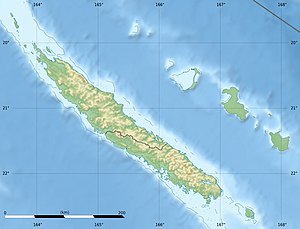
| Geographical location | 22 ° 37 ′ S , 167 ° 29 ′ E | |
|
|
||
| length | 17.7 km | |
| width | 13.7 km | |
| surface | 130 km² | |
| Highest elevation |
Pic N'Ga 262 m |
|
| Residents | 1969 (2009) 15 inhabitants / km² |
|
| main place | Vao | |
| Upi Bay in the east of the island | ||
The Île des Pins ( German pine island ; Kanak Kunyié ) is an island that belongs to the French overseas territory of New Caledonia .
geography
L'Île des Pins is around 130 km² (the exact area of 141.4 km² includes the offshore island Koutoumo to the south ) and had a population of 1969 in 2009. It belongs to the southern province of New Caledonia and forms the municipality of L'Île -des-Pins , which also includes the island of Walpole , 150 km to the east . The main town and administrative seat is Vao (Île des Pins) , the largest town, second largest town and main port is Kuto (Île des Pins) . The longest river is the Ouro in the west of the island. The highest point, the 262 m high Pic N'Ga , is located in the southwest of the island.
Tribes
The island's population, which corresponds to a district coutumier (roughly traditional district), is traditionally divided into eight tribes , clockwise, starting in the northwest: Gadji, Wapan, Touêté, Ooatchia, Youati, Vao, Comagna, Kere.
Economy and tourism
Tourism is by far the most important industry in L'Île des Pins. The island has a nickname in French: l'île la plus proche du paradis, which means "the next island to paradise". Among the tourists who visit the island are numerous scuba divers who come for the beautiful lagoon, which is home to numerous species of fish and coral. It is often visited by cruise ships. Most of the accommodations belong to the upper price category. Although many of the local families plant some vegetables and fruit on their property for their own use, agriculture is only of minor importance. No fields or arable land have been created on the Ile des Pins and there are only a few cows on the island. In Vao, the capital of the Ile des Pins, the traditional pirogues are still being built. Vanilla is grown to a limited extent near the town of Koéville. About 300 residents of the Ile des Pins work on the main island of New Caledonia and only return to the island for occasional visits.
history
James Cook discovered the Île des Pins for the western world on his second circumnavigation in 1774 and gave it its name because of the dense forest with araucarias of the species Araucaria columnaris . Cook's expedition did not go ashore. However, the island was inhabited, which was derived from the numerous columns of smoke that could be seen.
In 1840 the first Protestant and in 1848 the first Catholic missionaries arrived on the island. Most of the inhabitants of the Ile des Pins converted to the Catholic faith. On September 29, 1853, Kaoua Vendegou, the most important chief of the Ile des Pins, agreed to take possession of the island by France and concluded a treaty with the French admiral Febvrier-Despointes.
The hydrographer Henry Mangles Denham measured the island on one of his expedition trips in 1853.
In 1858 around 700 people lived on the island, and a little later another 900 people from the island of Maré , who had been expelled from there because of their Catholic faith , settled here .
In 1860 the construction of the Catholic Church Notre Dame de l'Assomption began in the south of the island , around which the village of Vao was built. The most powerful chief of the Ile des Pins also settled here. Before that he lived in Gadji in the north of the island, which was originally the most important town on the Ile des Pins.
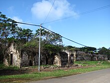
After the defeat of the Paris Commune in 1871, many of those sentenced to exile were taken to the Île des Pins. Of the 5 convict colonies in the west of the island, only a water tower and some overgrown ruins of the Bagno were visible in 2010 .
traffic
The island can be reached from Nouméa three times a week by ferry and three times a day by plane. The airfield is roughly in the middle of the island. Public transport is not available on the island, but rental cars are available. The island is accessed by a well-developed ring road, from which numerous branch roads branch off to individual houses, towns and sights. Some particularly striking points, e.g. B. on the Pic N'Ga, lead hiking trails.
Attractions
In Ouro, a small scattered settlement in the west of the island, the ruins of one of the five convict colonies have been preserved, as well as the water tower built by prisoners in 1874/75 and renovated in 2005, which still serves its purpose today. The representative outside staircase of the administration building is well preserved, as are 42 prison cells, which, like the surrounding wall, have been freed from the tropical vegetation. The convict colony stretched on both sides of today's main street from Ouro.
Not far north of Ouro is a cemetery worth a visit, the Cimetière des Déportés , where 240 prisoners of the Paris Commune who died between 1872 and 1880 are buried. A pyramid-shaped memorial built by prisoners commemorates the deceased. Between the village of Ouro and the cemetery, the jungle stretches along the Ouro, the longest river on the island.
In the interior of the island, in an uninhabited area, there are about 400 grave mounds of unknown age that are heavily overgrown by plants and difficult to make out in the densely vegetated landscape, each of which is 7 to 8 m in diameter and up to 1.20 m high. It was not until 1959 that archaeological excavations determined that it was a burial mound.
The scattered settlement of Koéville , near which vanilla is grown, is known for the stalactite cave Grotte de la Troisième , which is sometimes also called Grotte de Diable (Devil's Grotto) .
Until the beginning of the 20th century, the small town of Gadji in the north of the island was the main town on the Île des Pins, as the most important chief lived here. His wooden residence fell victim to a major fire in 1910. Today Gadji is known for its location on the Baie de Gadji bay , which is particularly popular with divers and where several islets of coral limestone protrude from the sea.
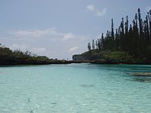
In the north-east of the island, at the Baie des Crabes bay , the lake Piscine naturelle, lined with coconut palms and araucarias , is a popular attraction.
The lagoon that surrounds the Île des Pins is specially protected as a natural heritage by UNESCO .
Web links
- Tourist card
- Tribal Map ( Tribu )
Individual evidence
- ↑ UN SYSTEM-WIDE EARTHWATCH Web Site: ISLAND DIRECTORY: Islands of New Caledonia (France)
- ↑ Pierre-Alain Pantz: Île des Pins - merveille de la nature , p. 9. Nouméa 2008
- ↑ Pierre-Alain Pantz: Ile des Pins - merveille de la nature , p. 35. Nouméa 2008
- ↑ pdavis.nl : William Loney RN: Henry Mangles Denham , in English, accessed on October 9, 2011
- ↑ Pierre-Alain Pantz: Île des Pins - merveille de la nature , p. 25. Nouméa 2008
- ↑ Pierre-Alain Pantz: Île des Pins - merveille de la nature , p. 81. Nouméa 2008
- ↑ Pierre Grundmann: Nouvelle Calédonie , p. 181. Paris 2012
- ↑ Pierre Grundmann: Nouvelle Calédonie , p. 182. Paris 2012


