Îles Saint-Marcouf
| Îles Saint-Marcouf | ||
|---|---|---|
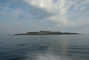
| View of the islands from the mainland | ||
| Waters | English Channel | |
| Geographical location | 49 ° 30 ′ N , 1 ° 9 ′ W | |
|
|
||
| Number of islands | 2 | |
| Main island | Île du Large | |
| Total land area | 14 km² | |
| Residents | uninhabited | |
| Île du Large with a round fortress | ||
The Îles Saint-Marcouf form an archipelago consisting of the two islands Île de Terre and Île du Large off the French Normandy coast in the English Channel . Originally the islands were called Duolimonis and were named after Saint Markulf (French: Saint Marcouf ).
geography
The islands are about 7 kilometers off the east coast of the Cotentin peninsula and belong to the municipality of Saint-Marcouf . The larger island, the Île du Large, is around 500 meters east of the smaller Île de Terre. The two islands are around 1,400 hectares and protrude a maximum of ten meters from the water.
The islands consist of Armorican sandstone and are therefore in the Armorican massif .
Since April 30, 1987, following a decision by the Prefect of the Manche department , the islands have been annexed to the municipality of Saint-Marcouf . The archipelago is owned by the French state. Access to the Île du Large is prohibited for security reasons. Access to the Île de Terre is also not allowed as it is a bird sanctuary .
history
British possession
In 1795 the English conquered the archipelago and obstructed the movement of goods in the Baie de Seine : the ships leaving Le Havre or Cherbourg-Octeville were stopped and their freight checked.
The first war submarine was used on the islands in 1800 on the instructions of Napoleon. The submarine Nautilus , built by Robert Fulton , attempted to attack the islands, but failed.
French possession
As part of the Peace of Amiens , the islands were returned to France in 1802. Napoléon had the larger island expanded into a fortress with fort in order to prevent any storming.
In World War II
Three weeks before the Allies landed in Normandy in 1944, it was suspected that a heavily armed German outpost might be on the islands. On D-Day , at 4:30 a.m., a commando swam to the islands and found that there were no Germans there. At 5:30 a.m. a mixed unit landed and the islands were occupied by the Americans.
literature
- Gérard Morizot: Histoire des îles Saint-Marcouf en Cotentin, jusq'au XIXe siècle ISBN 2-9516531-0-7
Web links
Individual evidence
- ↑ Guide geologique Normandie Maine. Editions DUNOD. 2nd edition. Page 75. ISBN 2-10-050695-1 .
- ↑ Les Anglais aux Îles Saint-Marcouf, L'Expédition de 1798 , Gabriel Vanel, Éd. Louis Jouan, Caen, 1910
- ^ Treaty of Amiens, 1802
- ^ Edmond Thin: Les Îles St-Marcouf. Histoire, navigation, écologie . OREP, Cully, 2000, p. 143
- ↑ Les îles Saint-Marcouf en 1944 ( Memento of May 8, 2014 in the Internet Archive )


