Baie de Seine

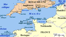
The Baie de Seine ( German Bay of the Seine ), rarely also Baie de la Seine , is located on the English Channel and includes the mouth of the Seine. It extends from the Pointe de Barfleur in the municipality of Gatteville-le-Phare north of Barfleur on the Cotentin peninsula in the west, to the Cap de la Hève near Le Havre in the east. Occasionally, the name Baie de Seine is restricted to the area of the Seine estuary, i.e. to the coast between Deauville and Le Havre.
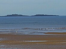
The Baie de Seine has a larger indentation called the Baie des Veys between the departments of Manche and Calvados . In the Baie de Seine are the small archipelago of Saint-Marcouf , located in the bay of Les Veys off the coast of the Cotentin peninsula . There is also Tatihou Island off Saint-Vaast-la-Hougue .
geology
The Baie de Seine is mainly located in the Paris Basin . Only in the northwest, between Saint-Vaast-la-Hougue and Pointe de Barfleur, does the coast belong to the Armorican massif . At the Pointe de Barfleur , granites come to the fore.
The Îles Saint-Marcouf are made of Armorican sandstone, and therefore belong to the Armorican massif.
Coastal towns
Cities with more than 10,000 inhabitants
Population between 5000 and 9999
Population between 1000 and 4999
Places with less than 1000 inhabitants
See also
Web links
Coordinates: 49 ° 30 ′ 0 ″ N , 0 ° 30 ′ 0 ″ W.
