Baie des Veys
| Baie des Veys | ||
|---|---|---|
| Waters | Baie de Seine | |
| Land mass | Western Europe | |
| Geographical location | 49 ° 22 '47 " N , 1 ° 8' 11" W | |
|
|
||
| width | approx. 5 km | |
| depth | approx. 5 km | |
| Tributaries | Douve , Vire | |
The Baie des Veys (German: Bay of Les Veys ) is a larger indentation of the Baie de Seine . The following rivers flow into the English Channel at this point : the Douve near Carentan and the Vire near Isigny-sur-Mer .
history
When the then 19-year-old Duke Wilhelm was in Valognes in 1047 , he was warned of a conspiracy by the Knights of Western Normandy who refused to recognize his rule. He fled south-east and crossed the Baie des Veys that night . For fear of being recognized, he avoided the cities. He arrived in the Bayeux area , where he was received by a loyal knight and led by his sons to Falaise . He asked the French King Henry I for help. Together with the French army, he won in Val-ès-Dunes .
The Baie des Veys is located between the landing beaches of Utah Beach and Omaha Beach .
geography
The Baie des Veys is bounded by the Cotentin peninsula and the Bessin . It is accessible via the RN13 and the Paris-Caen-Cherbourg railway line .
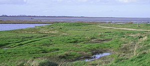
The bay is located in the Marais du Cotentin et du Bessin Regional Nature Park . The bay is shallow, the tide differences are great. In this sense, it forms the counterpart to the Baie du Mont-Saint-Michel , which is on the other side of the Cotentin peninsula , even if the tidal differences are not as significant here as in the Baie du Mont-Saint-Michel, and also when the Baie du Mont-Saint-Michel is bigger. At low tide, the Baie des Veys is a sandy desert of 7 km².
At high tide, the canals that lead either to Carentan or Isigny-sur-Mer must be used. By the 1960s, wood was imported from the north and butter exported.
Before polders were created in the 19th century , a distinction was made between the Grand Vey and the Petit Vey .
The Grand Vey formed the largest northern part between Sainte-Marie-du-Mont , Brévands and Géfosse-Fontenay . At low tide the ford consisted of shallows of sand. There was the 8 km long Roman path between Alauna ( Valognes ) and Augustodurum ( Bayeux ). Four main fords were waded through, namely:
- Gué (ford) from Carentan
- Ford of Brévands
- Ford of Vire
- Ford of Isigny-sur-Mer.
The main shallows were from north to south:
- Le banc (shoal) du Nord
- Les Rouelles
- Le banc (shoal) de Fer
- Le banc (shoal) Ferraillon
- Le banc (shallow) de l'Islette
- Le banc (shoal) de la Madeleine
- Le banc (shoal) du camp
The Petit Vey was nothing more than the confluence of the Vire , which flowed into the Grand Vey. An old road crosses the Petit Vey.
Oysters are raised in the bay . Of the 30,000 tons bred in Normandy each year, 10,000 tons come from Isigny-sur-Mer and Utah Beach .
It is not only fished , but also cockles collected and on the banks or in the gabions and waterfowl hunting.
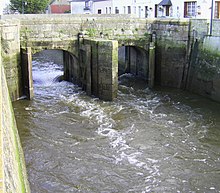
In the Baie des Veys there are four so-called portes à flot , simple locks , namely:
- Ponts au Douet et aux Vaches on the Aure in Isigny-sur-Mer
- on the Taute in Saint-Hilaire-Petitville
- Pont de la Barquette on the Douve in Carentan
- Pont du Vey on the Vire between Isigny-sur-Mer and les Veys
The portes à flot close at high tide and open at low tide without electricity, only with the pressure difference. Without it, the sea would invade the land.
Ramsar site
On April 8, 1991, the Baie des Veys was designated as a Ramsar site .
bibliography
- Philippe Pesnelle: La Baie des Veys. in: Passé simple. Alan Sutton Publishing House, Saint-Cyr-sur-Loire 2004, ISBN 2-84910-083-8 .
Individual evidence
- ^ Marc Morris: The Norman Conquest. Windmill books 2013. pp. 56–58. ISBN 978-0-09-953744-1 .
- ↑ a b Morière 1858 étude Normannia ( Memento of November 20, 2008 in the Internet Archive ), p. 499.
- ↑ Carte de l'ancien diocèse de Coutances, 1689 online at BnF / Gallica .
- ↑ Patrimoine hydraulique: les portes à flot ( Memento of the original from March 29, 2014 in the web archive archive.today ) Info: The archive link was inserted automatically and has not yet been checked. Please check the original and archive link according to the instructions and then remove this notice. (French)
- ↑ (en) [1]


