
Saint-Vaast-la-Hougue
| Saint-Vaast-la-Hougue | ||
|---|---|---|
|
||
| region | Normandy | |
| Department | Some | |
| Arrondissement | Cherbourg | |
| Canton | Val-de-Saire (main town) | |
| Community association | Cotentine | |
| Coordinates | 49 ° 35 ′ N , 1 ° 16 ′ W | |
| height | 0-15 m | |
| surface | 6.28 km 2 | |
| Residents | 1,730 (January 1, 2017) | |
| Population density | 275 inhabitants / km 2 | |
| Post Code | 50550 | |
| INSEE code | 50562 | |
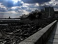
 General view of Saint-Vaast-la-Hougue |
||

Saint-Vaast-la-Hougue is a French municipality and a seaside resort on the northeast coast of the peninsula Cotentin in the department of Manche in the region of Normandy . It belongs to the canton of Val-de-Saire in the Arrondissement of Cherbourg .
Toponymy
The place is named after the Holy Vedast († 540), Bishop of Arras . The word "Hougue" comes from the Old Norman Hogue with the Cotentin pronunciation [u] for [ɔ], is derived from the Old Norse word " haugr " and means "hill" or "height".
The place
Saint-Vaast-la-Hougue is located on the Cotentin peninsula , in the Val de Saire countryside .
The city has 1,730 inhabitants (as of January 1, 2017), in 1962 there were still more than 2,400. The 29 hectare island of Tatihou , located about 1 km off the coast and sometimes accessible on foot at low tide, belongs to the municipality of Saint-Vaast- la-Hougue. The total area of Saint-Vaast has a size of 6.28 km².
On the southern edge of the village is Fort de la Hougue, built in 1694 by Benjamin de Combes (approx. 1649–1710), a pupil of Vauban , which is still a military base today and is only open to the public for visits a few days a year.
The port of Saint-Vaast-la-Hougue was expanded during the 19th century. The large pier was built between 1828 and 1845, the quay from 1846 to 1852. The breakwaters were then built to delimit the port area, which remained open to the sea until 1982, but then opened through a double gate between the fishing and 1980s Marina (665 berths) was closed. Both are only accessible to boats at high tide. The pier fire at the end of the pier has been in operation since 1865. In the final stages of World War II , the port was the first port of Normandy conquered by the Allies in 1944.
The bay of Saint-Vaast-la-Hougue is of ornithological importance; more than a hundred different species of birds can be found there. Guided tours are conducted by the Normandy Ornithological Group (GONms).
history


When Edward III. of England in 1346, at the beginning of the Hundred Years War , tried to enforce his claim to the crown of France militarily, he landed on July 12 with an invading army of 15,000 men in the bay of Saint-Vaast. From there he conquered Caen , marched through northern France and met the army of the French king Philip VI at Crécy on August 26th . , whom he and his longbowmen inflicted a heavy defeat in the battle of Crécy .
In 1692, in the course of the War of the Palatinate Succession , after the undecided sea battle of May 29 at Barfleur , twelve French ships of the line anchored in the bay of La Hougue and on the island of Tatihou. There they were attacked and destroyed by English fires on June 3rd and 4th in an action celebrated in England as the "Battle of La Hogue" .
To prevent further English attacks on the bay, fortification towers were built in 1694 by the fortress engineer Benjamin de Combes on the hill of La Hougue and on the opposite island of Tatihou. The two towers have been registered as UNESCO World Heritage since July 2008, along with eleven other fortresses built by Vauban .
economy
The oyster farming is an important source of income the city, with about 250 hectares at low tide lying dry oyster beds. The bay of Saint-Vaast is the oldest oyster farming region in Normandy.
Tourism is a second important source of income. The place has numerous hotels, restaurants and campsites .
Attractions
- The Chapel of the Sailors (La chapelle des marins), a monument historique since 1952 , is the choir of the former town church, which was demolished in 1864. The Romanesque round apse dates from the 11th century.
- The island of Tatihou , sometimes accessible on foot at low tide and otherwise by amphibious vehicle , with the Vauban tower, the Maritime Museum in the upstream Fort de l'Ilet, a botanical garden and a bird sanctuary.
- The fortifications of La Hougue and Tatihou.
Cultural event
Every summer in Saint-Vaast-la-Hougue, the “Ancres et Encres” book festival takes place. In 2020 it had to be canceled due to the corona pandemic.
Town twinning
gallery
Saint-Vaast-la-Hougue

The pier fire
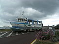
Tatihou II , the amphibious vehicle that connects Tatihou with Saint-Vaast-la-Hougue, swimming at high tide and on wheels at low tide

Saint-Vaast-la-Hougue, port


Individual evidence
- ↑ Old Norse Words in the Norman Dialect (The Vikings in Normandy)
- ↑ Place names derived from the Old Norse words (The Vikings in Normandy)
- ↑ la commune de Saint-Vaast-la-Hougue (INSEE commune file)
- ↑ Les fortifications Vauban inscrites au patrimoine mondial. ( Memento of August 13, 2008 in the Internet Archive ) NouvelObs.com , July 7, 2008.
- ↑ Pascal Leygoute: À la pointe du Cotentin. ( Memento of September 12, 2005 in the Internet Archive ) In: L'Express , December 6, 2004.
- ↑ ANNULE - Ancres et Encres, festival du livre de mer et d'aventure - SAINT-VAAST-LA-HOUGUE. Retrieved June 28, 2020 (Fri-FR).
Web links
- Official website of the municipality (French)