
Réville
| Réville | ||
|---|---|---|
.svg)
|
|
|
| region | Normandy | |
| Department | Some | |
| Arrondissement | Cherbourg | |
| Canton | Val-de-Saire | |
| Community association | Cotentine | |
| Coordinates | 49 ° 37 ′ N , 1 ° 15 ′ W | |
| height | 0-16 m | |
| surface | 10.55 km 2 | |
| Residents | 1,038 (January 1, 2017) | |
| Population density | 98 inhabitants / km 2 | |
| Post Code | 50760 | |
| INSEE code | 50433 | |
 Town hall (Mairie) of Réville |
||

Reville is a French commune with 1,038 inhabitants (as of January 1 2017) in the department of Manche in the region of Normandy . The municipality belongs to the arrondissement of Cherbourg and the canton of Val-de-Saire (until 2015: canton of Quettehou ). The inhabitants are called Révillais .
geography
Réville is located about 25 kilometers east-southeast of Cherbourg-Octeville at the northeastern end of the Cotentin peninsula in the Val de Saire landscape on the Seine bay . Réville is surrounded by the neighboring communities of Montfarville in the north, Saint-Vaast-la-Hougue in the south, La Pernelle in the west and south-west and Anneville-en-Saire in the west and north-west.
history
| Population development | ||||||||
|---|---|---|---|---|---|---|---|---|
| year | 1962 | 1968 | 1975 | 1982 | 1990 | 1999 | 2006 | 2013 |
| Residents | 1,383 | 1,308 | 1,233 | 1,246 | 1,205 | 1,168 | 1,198 | 1,173 |
| Source: Cassini and INSEE | ||||||||
Attractions
- Viking necropolis
- Saint-Martin church, monument historique since 1923
- Saint-Éloi chapel, historic monument since 1997
- Réville Castle, Monument historique since 1997
- La Crasvillerie manor house
- lighthouse

Saint Martin Church

Saint-Éloi chapel

Réville Castle
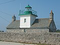
lighthouse


Parish partnership
A partnership has existed with the British community of Hambledon in Hampshire (England) since 1991.
Personalities
- François Le Clerc (died 1563), pirate
- Guillaume Fouace (1837–1895), painter