
La Pernelle
| La Pernelle | ||
|---|---|---|
|
||
| region | Normandy | |
| Department | Some | |
| Arrondissement | Cherbourg | |
| Canton | Val-de-Saire | |
| Community association | Communauté d'agglomération du Cotentin | |
| Coordinates | 49 ° 37 ′ N , 1 ° 18 ′ W | |
| height | 1–121 m | |
| surface | 7.23 km 2 | |
| Residents | 259 (January 1, 2017) | |
| Population density | 36 inhabitants / km 2 | |
| Post Code | 50630 | |
| INSEE code | 50395 | |
 Mairie La Pernelle |
||

La Pernelle is a commune with 259 inhabitants (as of January 1 2017) in the Manche department in the region of Normandy . It belongs to the Arrondissement of Cherbourg and the Canton of Val-de-Saire .
geography
The municipality is located in the Val de Saire countryside on the Cotentin peninsula . The Saire forms the border with Réville in the east . Other neighboring communities are Le Vast in the northwest, Le Vicel in the north, Anneville-en-Saire in the northeast, Saint-Vaast-la-Hougue in the southeast, Quettehou in the southwest and Teurthéville-Bocage in the west.
Population development
| year | 1962 | 1968 | 1975 | 1982 | 1990 | 1999 | 2008 | 2015 |
|---|---|---|---|---|---|---|---|---|
| Residents | 266 | 277 | 226 | 301 | 293 | 303 | 252 | 253 |
Attractions
- Sainte-Pétronille church, historic monument since 1975
- Manoir d'Ourville, mansion, monument historique
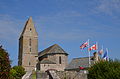
Sainte-Pétronille church

Manoir d'Ourville
.JPG)
.JPG)
Web links
Commons : La Pernelle - Collection of images, videos and audio files