
Canville-la-Rocque
| Canville-la-Rocque | ||
|---|---|---|
|
||
| region | Normandy | |
| Department | Some | |
| Arrondissement | Cherbourg | |
| Canton | Créances | |
| Community association | Communauté d'agglomération du Cotentin | |
| Coordinates | 49 ° 21 ′ N , 1 ° 38 ′ W | |
| height | 7–43 m | |
| surface | 5.35 km 2 | |
| Residents | 129 (January 1, 2017) | |
| Population density | 24 inhabitants / km 2 | |
| Post Code | 50580 | |
| INSEE code | 50097 | |

Canville-la-Rocque is a French municipality with 129 inhabitants (as of January 1 2017) for the Manche department in the region of Normandy . It belongs to the Arrondissement of Cherbourg and the canton of Créances .
location
The municipality is located on the Cotentin peninsula . It is bordered by Portbail to the north-west, Besneville to the north, Neuville-en-Beaumont to the north-east, Saint-Sauveur-de-Pierrepont to the south-east, Denneville (point of contact) to the south and Port-Bail- sur-Mer with Saint-Lô-d'Ourville .
Population development
| year | 1962 | 1968 | 1975 | 1982 | 1990 | 1999 | 2008 | 2015 |
|---|---|---|---|---|---|---|---|---|
| Residents | 216 | 201 | 182 | 158 | 146 | 129 | 129 | 134 |
Attractions
- Château d'Olonde, Monument historique since 2000
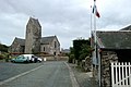
- Saint Malo church

Château d'Olonde
Saint Malo church


Web links
Commons : Canville-la-Rocque - collection of images, videos and audio files