
Carneville
| Carneville | ||
|---|---|---|
|
||
| region | Normandy | |
| Department | Some | |
| Arrondissement | Cherbourg | |
| Canton | Val-de-Saire | |
| Community association | Communauté d'agglomération du Cotentin | |
| Coordinates | 49 ° 40 ′ N , 1 ° 27 ′ W | |
| height | 30-139 m | |
| surface | 6.88 km 2 | |
| Residents | 236 (January 1, 2017) | |
| Population density | 34 inhabitants / km 2 | |
| Post Code | 50330 | |
| INSEE code | 50101 | |
 Mairie from Carneville |
||

Carnesville is a French municipality with 236 inhabitants (as of January 1 2017) in the Manche department in the region of Normandy . It belongs to the Arrondissement of Cherbourg and the Canton of Val-de-Saire .
location
The municipality is located in the Val de Saire countryside on the Cotentin peninsula . It borders in the north on Fermanville , in the northeast on Cosqueville , in the east on Théville , in the south on Gonneville-Le Theil with Gonneville and in the west on Maupertus-sur-Mer .
Population development
| year | 1962 | 1968 | 1975 | 1982 | 1990 | 1999 | 2008 | 2015 |
|---|---|---|---|---|---|---|---|---|
| Residents | 219 | 194 | 177 | 213 | 241 | 222 | 225 | 238 |
Attractions
- Saint Malo church
- Château de Carneville, monument historique since 1975
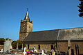
Saint Malo church

Château de Carneville
.JPG)
.JPG)
Web links
Commons : Carneville - collection of images, videos and audio files