Hardinvast
| Hardinvast | ||
|---|---|---|
|
|
||
| region | Normandy | |
| Department | Some | |
| Arrondissement | Cherbourg | |
| Canton | Cherbourg-Octeville-3 | |
| Community association | Cotentine | |
| Coordinates | 49 ° 35 ′ N , 1 ° 39 ′ W | |
| height | 67-172 m | |
| surface | 7.30 km 2 | |
| Residents | 881 (January 1, 2017) | |
| Population density | 121 inhabitants / km 2 | |
| Post Code | 50690 | |
| INSEE code | 50230 | |
| Website | www.mairiehardinvast.fr | |
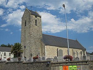
 Saint Barthélemy Church |
||
Hardinvast is a commune in the department of Manche in the region of Normandy . The inhabitants call themselves Hardinvastais .
Toponymy
Hardinvast is derived from the Germanic (or Anglo-Saxon) name Hardinc . For the ending -vast , see Le Vast .
geography
Hardinvast is located on the Cotentin peninsula , near Cherbourg . The landscape is a bocage landscape.
Adjacent municipalities are:
history
The remains of a Merovingian necropolis have been discovered. Hardinvast can look back on 1,000 years of history. However, there is no trace of churches in the Middle Ages. The church was built in the 18th century and recently renovated. The church tower dates back to the 19th century.
Attractions
- Saint-Barthélemy church from the 18th century.
- Beaurepaire Castle, partly on Hardinvast (see Martinvast ), has been added to the list of historical monuments.
Personalities
- Emmanuel Liais (1826–1900), astronomer, botanist, explorer, mayor and general councilor of Cherbourg is buried in Tollevast.
Individual evidence
- ↑ René Lepelley. Dictionnaire étymologique des noms de communes de Normandie . Presses universitaires de Caen . Page 142. ISBN 2-905461-80-2
- ↑ Domaine de Beaurepaire (également sur commune de Martinvast) in the Base Mérimée of the French Ministry of Culture (French).
- Altitudes, coordonnées, superficie : répertoire géographique des communes 2013 (site de l'IGN, téléchargement du 19 mars 2014)


