
Lestre
| Lestre | ||
|---|---|---|
|
||
| region | Normandy | |
| Department | Some | |
| Arrondissement | Cherbourg | |
| Canton | Valognes | |
| Community association | Communauté d'agglomération du Cotentin | |
| Coordinates | 49 ° 32 ′ N , 1 ° 20 ′ W | |
| height | 1-45 m | |
| surface | 7.57 km 2 | |
| Residents | 248 (January 1, 2017) | |
| Population density | 33 inhabitants / km 2 | |
| Post Code | 50310 | |
| INSEE code | 50268 | |

Lestre is a French municipality with 248 inhabitants (at January 1, 2017) in the department of Manche in the region of Normandy . It belongs to the canton of Valognes and the arrondissement of Cherbourg .
location
Lestre is located on the Cotentin peninsula and borders to the east on the estuary formed by the Seine , a bay of the English Channel . The municipality is bordered to the north by Aumeville-Lestre , to the south by Quinéville , to the southwest by Ozeville and Vaudreville and to the northwest by Saint-Martin-d'Audouville and Octeville-l'Avenel .
Population development
| year | 1962 | 1968 | 1975 | 1982 | 1990 | 1999 | 2008 | 2015 |
|---|---|---|---|---|---|---|---|---|
| Residents | 397 | 366 | 277 | 230 | 256 | 224 | 246 | 256 |
Attractions
- Saint Martin Church
- Ruins of the Saint-Michel chapel, monument historique since 1862
- Château de Tourville, Monument historique since 2006

Saint Martin Church

The former Saint-Michel chapel
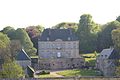
Château de Tourville

Former Lestre– Quinéville train station , in operation from 1886 to 1948
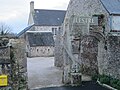
Mairie Lestre
.JPG)

.jpg)


Web links
Commons : Lestre - collection of images, videos and audio files