
Anneville-en-Saire
| Anneville-en-Saire | ||
|---|---|---|
.svg)
|
|
|
| region | Normandy | |
| Department | Some | |
| Arrondissement | Cherbourg | |
| Canton | Val-de-Saire | |
| Community association | Communauté d'agglomération du Cotentin | |
| Coordinates | 49 ° 38 ′ N , 1 ° 17 ′ W | |
| height | 1–111 m | |
| surface | 6.00 km 2 | |
| Residents | 390 (January 1, 2017) | |
| Population density | 65 inhabitants / km 2 | |
| Post Code | 50760 | |
| INSEE code | 50013 | |
 Mairie Anneville-en-Saire |
||

Anneville-en-Saire is a French municipality with 390 inhabitants (at January 1, 2017) in the Manche department in the region of Normandy . It belongs to the canton of Val-de-Saire and the Arrondissement of Cherbourg .
Neighboring municipalities are Valcanville in the northwest, Montfarville in the northeast, Réville in the southeast, La Pernelle in the southwest and Le Vicel in the west.
Population development
| year | 1962 | 1968 | 1975 | 1982 | 1990 | 1999 | 2008 | 2015 |
|---|---|---|---|---|---|---|---|---|
| Residents | 435 | 425 | 407 | 374 | 345 | 324 | 375 | 397 |
Attractions
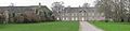
- Château du Tourps, Monument historique since 2005
- Maison d'Anneville, Monument historique since 1975
- Saint-Léger church

Château du Tourps
Maison d'Anneville

Web links
Commons : Anneville-en-Saire - collection of images, videos and audio files