
Taillepied
| Taillepied | ||
|---|---|---|
|
||
| region | Normandy | |
| Department | Some | |
| Arrondissement | Cherbourg | |
| Canton | Bricquebec | |
| Community association | Communauté d'agglomération du Cotentin | |
| Coordinates | 49 ° 22 ′ N , 1 ° 35 ′ W | |
| height | 7-48 m | |
| surface | 2.15 km 2 | |
| Residents | 21 (January 1, 2017) | |
| Population density | 10 inhabitants / km 2 | |
| Post Code | 50390 | |
| INSEE code | 50587 | |

Taillepied is a French municipality with 21 inhabitants (at January 1, 2017) in the department of Manche in the region of Normandy . It belongs to the Arrondissement of Cherbourg and the Canton of Bricquebec . The residents are called waist pétais .
It borders in the north on Saint-Sauveur-le-Vicomte , in the east on Catteville , in the south on Neuville-en-Beaumont and in the west on Besneville .
Population development
| year | 1962 | 1968 | 1975 | 1982 | 1990 | 1999 | 2008 | 2015 |
|---|---|---|---|---|---|---|---|---|
| Residents | 59 | 62 | 54 | 41 | 26th | 25th | 29 | 26th |
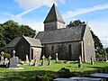
Saint-Jean-Baptiste church on the 91 m high Mont de Taillepied
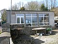
Mairie Taillepied


Web links
Commons : Taillepied - collection of images, videos and audio files