
Colomby
| Colomby | ||
|---|---|---|
.svg)
|
|
|
| region | Normandy | |
| Department | Some | |
| Arrondissement | Cherbourg | |
| Canton | Bricquebec | |
| Community association | Communauté d'agglomération du Cotentin | |
| Coordinates | 49 ° 27 ′ N , 1 ° 30 ′ W | |
| height | 7-44 m | |
| surface | 11.16 km 2 | |
| Residents | 537 (January 1, 2017) | |
| Population density | 48 inhabitants / km 2 | |
| Post Code | 50700 | |
| INSEE code | 50138 | |

Colomby is a French municipality with 537 inhabitants (as of January 1 2017) in the Manche department in the region of Normandy . It belongs to the Arrondissement of Cherbourg and the Canton of Bricquebec .
location
Colomby is located on the Cotentin peninsula . Neighboring municipalities are Morville and Lieusaint in the north, Flottemanville and Hémevez in the Northeast, Urville in the east, Hautteville-Bocage in the southeast, Biniville in the south, Golleville in the southwest and Magneville in the West
Population development
| year | 1962 | 1968 | 1975 | 1982 | 1990 | 1999 | 2008 | 2015 |
|---|---|---|---|---|---|---|---|---|
| Residents | 434 | 417 | 388 | 371 | 431 | 429 | 477 | 519 |
Attractions
- Saint-Georges church, historic monument since 1966
- former rectory, today town hall ( Mairie ), monument historique since 1996
- Farm Ferme du Breuil

Saint-Georges church
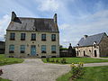
Mairie Colomby
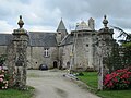
Ferme du Breuil


Web links
Commons : Colomby - collection of images, videos and audio files