
Rauville-la-Place
| Rauville-la-Place | ||
|---|---|---|
.svg)
|
|
|
| region | Normandy | |
| Department | Some | |
| Arrondissement | Cherbourg | |
| Canton | Bricquebec | |
| Community association | Communauté d'agglomération du Cotentin | |
| Coordinates | 49 ° 23 ′ N , 1 ° 30 ′ W | |
| height | 2–46 m | |
| surface | 11.88 km 2 | |
| Residents | 376 (January 1, 2017) | |
| Population density | 32 inhabitants / km 2 | |
| Post Code | 50390 | |
| INSEE code | 50426 | |
 Mairie Rauville-la-Place |
||

Rauville-la-Place is a French municipality with 376 inhabitants (at January 1, 2017) in the Manche department in the region of Normandy . It belongs to the Arrondissement of Cherbourg and the Canton of Bricquebec .
location
It is located on the Cotentin peninsula and borders in the north with Sainte-Colombe , in the northeast with Reigneville-Bocage and La Bonneville , in the east with Crosville-sur-Douve , in the southeast with Varenguebec and in the south and west with Saint-Sauveur-le- Viscount .
Population development
| year | 1962 | 1968 | 1975 | 1982 | 1990 | 1999 | 2008 | 2016 |
|---|---|---|---|---|---|---|---|---|
| Residents | 585 | 511 | 418 | 397 | 418 | 432 | 386 | 381 |
Attractions
- Notre-Dame de la Délivrande chapel
- Saint Laurent Church
- Manoir de Garnetot , mansion Monument historique since 1979

Notre-Dame de la Délivrande chapel
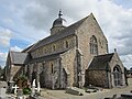
Saint Laurent Church

Manoir de Garnetot

.JPG)

Web links
Commons : Rauville-la-Place - collection of pictures, videos and audio files