
Huberville
| Huberville | ||
|---|---|---|

|
|
|
| region | Normandy | |
| Department | Some | |
| Arrondissement | Cherbourg | |
| Canton | Valognes | |
| Community association | Cotentine | |
| Coordinates | 49 ° 31 ′ N , 1 ° 26 ′ W | |
| height | 29-118 m | |
| surface | 5.76 km 2 | |
| Residents | 369 (January 1, 2017) | |
| Population density | 64 inhabitants / km 2 | |
| Post Code | 50700 | |
| INSEE code | 50251 | |
 Town hall ( mairie ) of Huberville |
||

Huberville is a French municipality with 369 inhabitants (as of January 1 2017) in the department of Manche in the region Normandy (2015 Basse-Normandie ). The municipality belongs to the Arrondissement of Cherbourg and to the municipal association Agglomération du Cotentin, founded in 2016 . The inhabitants call themselves Hubervillais .
geography
Huberville is located about 22 kilometers southeast of Cherbourg-en-Cotentin on the Cotentin peninsula . The English Channel coast is 13 kilometers east of Huberville. Huberville is surrounded by the neighboring communities of Tamerville in the northwest and north, Saint-Germain-de-Tournebut in the east, Saint-Cyr in the southeast, Sortosville and Flottemanville in the south and Valognes in the west. The landscape is mostly flat at around 50 meters above sea level. The upper Merderet borders the municipality in the northwest . At 118 m, the hill Le Mont in the east of the municipality is the highest point. There is no central, grown village core in the community, rather the community consists of many small hamlets and individual farms in the middle of a small-scale arable landscape dominated by countless hedges. The Mairie (town hall) is located in the district of Le Ronquier in the west, the church of Saint-Pierre-ès-Liens between the districts of Anneville and Hameau Dubost on the northeastern municipal boundary .
The districts of Huberville are called:
|
|
|
|
|
Place name
In 1056 the name Hubertivilla appeared for the first time in a register. The place name comes from the Germanic personal name Hubertus .
Population development
| year | 1962 | 1968 | 1975 | 1982 | 1990 | 1999 | 2007 | 2016 |
| Residents | 243 | 246 | 227 | 248 | 241 | 281 | 336 | 369 |
| Sources: Cassini and INSEE | ||||||||
Attractions


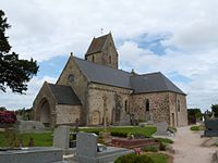
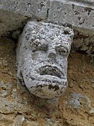
- The origins of the Saint-Pierre-ès-Liens church probably date back to the 11th century. Noteworthy are the framed Romanesque capitals, decorated with chimeras and plant motifs, as well as an arch decorated with rafters and pearls. The choir was rebuilt in the 13th century. The pillars that support the vault (reconstructed in the 19th century) are crowned with carved capitals decorated with human heads and plant hooks. On the south side there is a tympanum decorated with a lily cross . Many changes were made to the church building during the 16th and 17th centuries. Then the western veranda and southern chapel were built, and new windows were installed in the choir and nave. The south chapel, dedicated to Notre-Dame, followed. In the limestone pavement of the 17th century there are three tombstones along the high altar, one under the benches and one on the north side of the choir. In the north wall of the choir there is an epitaph coat of arms of the Bauquet family. A washbasin from the 14th century has been preserved on the south wall of the choir, and another from the 17th century in the south wall of the Notre-Dame chapel. There is a limestone shield from the 17th century near the north side altar. In the northern chapel, the limestone altar table dates from the 15th century. The church was in a deplorable state at the end of the revolutionary period. The current bell from Villedieu-les-Poêles, named Louise-Marie, dates from 1825.
- The building of today's Mairie (town hall) in the district of Le Roquier is made of sandstone and limestone and was bought by the municipality in 1851. It originally served as a primary school until it was closed in the 1980s.
- Lavoirs in the hamlets of Hameau du Tôt and Hameau Clémence
- The manor house of Franqueterre ( Manoir de Franquwterre ) has been documented in writing since 1238, when a deed was about a donation to the Vœu Abbey in Cherbourg. The most reliable sources, however, only concern the Vaultier family, then owners of the estate, from the 16th century onwards. The latter appears in two surveys of the nobility carried out in 1576 and 1598. The architecture of the manor house shows traces from the 15th and 16th centuries, at the end of the 17th century the manor house was rebuilt with large windows. The outbuildings consist of barns, sheds, granaries, wells, bread ovens and dovecotes.
- The Anneville manor house ( Manoir d'Anneville ) belonged to the Anneville family for a long time and its oldest parts date back to the 15th century. King Francis I was received here in 1532 . In the 17th century the facades were reworked and moats were created. In 1666 a younger branch of the Vaultier family was named as the owner.
- The Cross of the English ( La croix des Anglais ) refers to an episode of the Hundred Years War when large numbers of English soldiers perished during a battle between English and French troops. It is not yet clear whether the event took place in 1364 or 1450. In its current state, the Yvetot sandstone cross is based on a replica from the 18th century; The iron clamps used come from repair work from the 19th century.
- La Métairie mansion from the 16th century
- several hall crosses
- Saint-Pierre-ès-Liens church in Huberville


.JPG)
.JPG)


Economy and Infrastructure
The municipality of Huberville is very rural. There are 21 farms in the municipality that specialize in growing grain as well as dairy farming and the breeding of horses, sheep and goats.
Huberville is connected to its neighboring communities by back roads. The RN 13 runs through the southern tip of the municipality from Cherbourg to Caen . Trains on the Mantes-la-Jolie – Cherbourg line stop at the train station in the small town of Valognes , four kilometers away .
supporting documents
- ↑ René Lepelley : Dictionnaire étymologique des noms de communes de Normandie, Condé-sur-Noireau, Éditions Charles Corlet, 1996 ( ISBN 2-905461-80-2 , notice BnF no FRBNF36174448), p. 150
- ↑ Huberville on cassini.ehess.fr
- ↑ Huberville on INSEE
- ↑ Farmers in Huberville on annuaire-mairie.fr (French)