
Gonneville (Manche)
| Gonneville | ||
|---|---|---|
.svg)
|
|
|
| local community | Gonneville-Le Theil | |
| region | Normandy | |
| Department | Some | |
| Arrondissement | Cherbourg | |
| Coordinates | 49 ° 38 ′ N , 1 ° 28 ′ W | |
| Post Code | 50330 | |
| Former INSEE code | 50209 | |
| Incorporation | January 1, 2016 | |
| status | Commune déléguée | |

Gonneville is a village and a former French community with 891 inhabitants (as of January 1 2017) in the department of Manche in the region of Normandy . It belonged to the Arrondissement of Cherbourg and the Canton of Val-de-Saire .
With effect from January 1, 2016, the former municipalities of Gonneville and Le Theil were merged to form a Commune nouvelle with the name Gonneville-Le Theil and have the status of a Commune déléguée in the new municipality . The administrative headquarters are in Gonneville.
location
Neighboring towns are Bretteville in the north-west, Maupertus-sur-Mer in the north, Carneville in the north-east, Brillevast in the east, Le Theil in the south, Le Mesnil-au-Val in the south-west and Digosville in the west.
Infrastructure
Population development
| year | 1962 | 1968 | 1975 | 1982 | 1990 | 1999 | 2008 | 2015 |
|---|---|---|---|---|---|---|---|---|
| Residents | 507 | 527 | 489 | 654 | 773 | 853 | 857 | 906 |
Sights, infrastructure
- Gonneville Castle, a historic monument since 1972
- Saint-Martin church, historic monument since 1972
- Station Turretot -Gonneville on the railway line from Graville-Sainte-Honorine to Tourville-les-Ifs

Castle of Gonneville
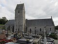
Saint Martin Church

Turretot – Gonneville station, photo from 1900
.JPG)

