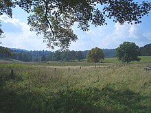
Česká Ves (Lesná)
Česká Ves (German: Böhmischdorf, 1685 Bömischen Torff, 1749 Boeheimisches Dorf, 1788 Böhmischdorf, 1885 Česká Ves) is a deserted area in the Czech Republic . The village was in the center of the 1136.9386 hectare cadastral area Česká Ves u Lesné in the municipality of Lesná in the Okres Tachov .
geography
Česká Ves was opposite the Georgenberg in Upper Palatinate in a side valley on the left side of the Celní potok . The western border of the municipality was the Czech-German border. In the north was the Kaltwasserrang with 711 m, in the south the Aschenstein (772 m) and the Schweinberg with 726 m.
history
The first mention of the village goes back to 1625. Although Böhmischdorf was the center of an area with several settlements and numerous industrial plants, it never really flourished.
In 1930 there were 24 houses with 125 inhabitants in the village. There were nine agricultural properties in the village, the Scharrer inn, a grocery store and a butcher's shop. In 1873 a three-class elementary school was established, from 1912 it became a four-class school. The residents belonged to the parish of Neulosimthal (Jedlina).
After the Munich Agreement , the place was added to the German Empire and until 1945 belonged to the Tachau district .
The cause of the downfall was the location at the Iron Curtain . The destruction of the houses took place in the years 1945-1950 due to a decree issued on July 30, 1948 by the Interior Ministry of Czechoslovakia. It concerned border crossings, all roads near the border and the liquidation of buildings in a strip about two kilometers wide along the state border. In 1955, Česká Ves was officially abolished and its corridors were added to the municipality of Lesná.
Settlements and glass processing companies
- Bohemian Neuhäusl
- Altpocher
- Neufürstenhütte
- Josefsthal
- Malo network
- Anna foreman
- Serious loop
- Neuwerk
- Anna loop
- Huts loop
literature
- Karl Lanzendörfer : The place names of the Tachau district . Writings on the local history of Tachau, Volume 11, new edition, Altenmarkt 2011.
- Zdeněk Procházka : Putování po zaniklých místech Českěho lesa, II. Tachovsko (walks through the disappeared settlements of the Bohemian Forest, II. Tachau District), Nakladadelství Českého lesa, Domažlice 2011, ISBN 978-80-87316-16-0 .
- Wolf-Dieter Hamperl : The disappeared villages . Volume III, Mediform-GmbH, Kienberg 2004. ISBN 3-9803622-0-5 .
Individual evidence
Web links
- Description on zanikleobce.cz
- Church register directory of the parish Neulosimthal on genealogienetz.de
Coordinates: 49 ° 43 ' N , 12 ° 27' E
