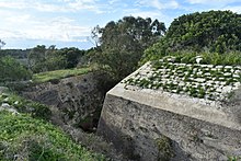
Żonqor Battery
The Zonqor Battery , also known as the Zonkor Battery in older plans , is a fortification on Malta . It was built in 1882 during the British rule over the islands. It is located on the northeast coast of the island about 500 m north of Marsaskala Bay and 0.9 km west of Żonqor Point . The battery is an example of the coastal fortifications in the late 19th and early 20th centuries.
prehistory
Immediately after the British took over the islands in 1800, the fortifications built by the Order of St. John were used almost unchanged. In accordance with the military theoretical ideas of the time, the Royal Navy operating in the Mediterranean was seen as the most reliable protection against an invasion of the islands. The situation changed, however, with the merging of the fleets of Sardinia , the Bourbons, Sicily and the Papal States on November 17, 1860 and the establishment of the Regia Marina Italiana on March 17, 1861. The beginning of the armament of the Italian fleet was seen by the British as a threat to them felt dominant role in the Mediterranean. In 1873 the Regia Marina laid the battleships Caio Duilio and Enrico Dandolo on Kiel. Equipped with four 450 mm cannons each and heavily armored, they were 15 knots faster than the British ships of that era. At the same time, artillery was revolutionized with the introduction of cannon firing shells. After the construction of the forts St Leonardo and St Rocco between 1872 and 1878, special attention was paid to the fortification of the south coast. The Zonqor Battery was designed to prevent possible landings in Marsaskala Bay and St Thomas Bay. In 1881 it was decided to build the battery. The battery should be equipped with three RML 64 pounder 64 cwt guns . The name of the fortification was then still San Nicola Battery . The first changes were made in the following year. As armament, three RML 7 inch 6½ ton guns were planned, which should be placed on or behind a parapet .
construction
The Zonqor Battery has the shape of a pentagon. The base is 60 m wide, the pentagon 42 m high. This makes the battery one of the smaller fortifications on Malta. It is surrounded by a ditch about 6 m wide. The fixed firing positions were in a central position within the battery. The entrances to the firing positions and the ammunition store are below the level of the surrounding area and are therefore largely protected against fire. The battery is accessed via the northern wall. There was no room for the waiter's accommodation.
In 1885 the facility was almost complete. The cost of building the facility was £ 5,000. However, it turned out that the guns could not reach the area of the bay that they were supposed to defend. In addition, the possible landing zones and the roads leading to them could not be reached. The battery of ships could also be fought at close range.
The battery was initially equipped with three RML 7 inch 7 ton guns. These are muzzle-loading cannons that could fire HE shells , shrapnel and full projectiles. The weight of a gun was around 6.5 t. Each cannon was capable of firing 2 to 3 rounds per minute. Neither range nor cadence could meet the requirements. Contemporary sources describe this type of gun as "the worst in the service".
Governor John Lintorn Arabin Simmons suggested building a position above the battery because of the defects found. The stationing of two to three mobile rapid-fire guns at the entrance to the bay was also considered. Ultimately, however, such plans were not implemented.
Use in World War II
The armament was dismantled before the beginning of the Second World War. During the war, the battery was used as a storage facility for ammunition.
Use after the Second World War
The battery is currently used for agricultural purposes.
See also
literature
- Quentin Hughes : Malta. A guide to the fortifications , Said International, 1993, ISBN 9990 943 07 9 .
- Charles Stephenson: The Fortifications of Malta 1530-1945. Osprey Publishing, 2004, ISBN 1-84176-836-7 .
Web links
- Correspondence between the Kunsill Lokali Marsaskala and the European Town Twinning Association (PDF; 739 kB)
Individual evidence
Coordinates: 35 ° 52 ′ 5.5 ″ N , 14 ° 33 ′ 52.7 ″ E


