
A971 road
| A971 road in the UK | |
| map | |
 |
|
| Basic data | |
| Operator: | |
| Start of the street: |
Veensgarth ( 60 ° 11 ′ N , 1 ° 14 ′ W ) |
| End of street: |
Melby ( 60 ° 18 ′ N , 1 ° 40 ′ W ) |
| Overall length: | 39.8 km (24.7 mi ) |
 |
|
| The A971 at Weisdale Voe | |
|
Course of the road
|
|
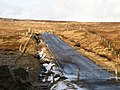
The A971 road is an A-road in Scotland . It connects the Walls peninsula in the west of the Shetland island of Mainland to the Ness of Melby to the road network. While it is initially expanded to two lanes, it is narrowed to one lane around three kilometers northeast of the Bridge of Walls.
course
The A971 branches off from the A970 ( Sumburgh - Isbister ) at Veensgarth . It leads in a north-westerly direction along the estuary Stromness Voe and Weisdale Voe and connects the villages of Whiteness , Haggersta , Hellister and Weisdale . It then reaches the bays Tresta Voe near Tresta , Bixter Voe near Bixter and Effirth Voe . Beyond Bixter the B9071 joins. About eight kilometers west of the A971 reached to Walls belonging Bridge of Walls at the head of Voe of Brown Country . While the road continues in a north-westerly direction, an A971 spur road leads to the center of Walls. After a further ten kilometers, you will first reach the hamlet of Sandness and finally the end of the road at a pier with a slipway in Melby .
With a total length of 39.8 km, the road connects the villages in the west of Mainland to Cape Ness of Melby opposite the island of Papa Stour . At Veengarth, it serves as the entrance to Tingwall Airport . The Scord of Brouster is also a Neolithic settlement along the road.
Former section of the A971 between Veensgarth and Whiteness

Bus stop west of Walls


Individual evidence
- ↑ Entry on Scord of Brouster in Canmore, the database of Historic Environment Scotland (English)