
A970 road
| A970 road in the UK | |
| map | |
 |
|
| Basic data | |
| Operator: | |
| Start of the street: |
Grutness ( 59 ° 52 ′ N , 1 ° 17 ′ W ) |
| End of street: |
Isbister ( 60 ° 36 ′ N , 1 ° 19 ′ W ) |
| Overall length: | 104.7 km (65.1 mi ) |
 |
|
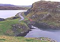
| View along the A970 | |
|
Course of the road
|
|
The A970 road is an A-road in Scotland . With a length of around 105 km, it is the longest road on the Shetland Islands , which connects the main island Mainland from the extreme south to the northern tip.
course
In the south, the road begins at the Sumburgh ferry terminal , which the ferry to the Fair Isle calls regularly. A path of Sumburgh airport around the leader, the A970 crosses the western end of the second track since the airport expansion in the year of 2006. A signal system on both sides of the intersection warns of air traffic. From then on, the road leads north through the elongated southern part of Mainland and connects numerous small towns on its way. Finally the A970 bends to the east to reach Lerwick, the main town on the island. Here the road only goes through the outskirts. The city center is accessible via the A969 , which branches off the A970 and joins it on the northern edge of Lerwick.
Beyond Lerwick, the road runs for around 3.5 km in a westerly direction. At the level of the Dales Voe estuary, the road bends north. A spur road, also run as the A970, goes from this point in a south-westerly direction to the center of Scalloway , around five kilometers away . A few kilometers north, the road leads past Tingwall Airport , the second airport on Mainland. This can be reached via the branching off A971 . The A971 forms the main thoroughfare of the Walls peninsula in the west of Mainland.
19 km to the north, at Hillside on the Olna Firth , the road bends to the northwest, while the A968 continues north and connects the islands of Yell and Unst via ferry connections . Via the isthmus of Mavis Grind , the A970 reaches the Northmavine peninsula , which it traverses in a north-south direction. Halfway through the A970, a spur road branches off to Hillswick on the Ura Firth, six kilometers away . The A970 itself ends after a total length of around 105 km in the hamlet of Isbister near the northern tip of Mainland.

Signal system before crossing the airfield

Former section of the A970 near Sandwick
On the isthmus of Mavis Grind


