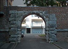
Aachen Gate (Jülich)
The Aachener Tor or the Rurpforte in Jülich is a remnant of the early modern city fortifications and was probably started around 1548 as part of the re-fortification of Jülich after the devastating city fire in 1547. Planning and execution were probably the responsibility of the Italian architect and state master builder Alessandro Pasqualini , who was responsible for the expansion of the city and its fortification. Behind the gate was the Jülich district, which remained relatively undamaged by the fire, as the preserved medieval witch's tower from the 14th century testifies to. The Aachener Tor served as the main entrance to the city from the west for over three hundred years and was accordingly heavily fortified. Above the archway was a brick gatehouse decorated with bluestone , which until 1798 carried a stone plaque in a field above the gate with the following inscription:
"GVILIELMVS DVX JVLIAE, CLIVIAE ET MONTIVM HOC PROPVGNACVLVM IN SALVTEM PATRIAE EXTRVXIT ANNO A PARTVR VIRGINIS MDXXXXVIII"
It identifies Duke Wilhelm V of Jülich-Kleve-Berg as the builder and dates the gate to the year 1548. A similar plaque was allegedly found on the Kölntor.
More recent excavations suggest that the Aachener Tor was initially in line with the older Hexenturm / Rurtores. The old Roman road was initially led over the ditch with a dam, which, strictly speaking, represented a weak point in the fortification, but was hardly significant due to the little threatened location near the river. A ravelin deviating from the central axis of the southwestern city curtain provided additional protection. It was only during the Spanish occupation that the gate was apparently moved to its current location around 1648 as part of construction work on this section of the wall. The eccentric ravelin now served in a reduced form as the preliminary work of a new, regular and larger ravelin. Another similarly dimensioned Vorwerk on the southern side of the new Ravelin created the symmetry. Stylistically, the gate is said to have fitted more into the 17th century, so that the conclusion that the gate was rebuilt at the new location and only the associated board was moved to the new location stands to reason.
In the maximum expansion phase between 1810 and 1860, access to the city from the west was secured through the bridgehead , the sluice bridge over the Rur , the city travel route 2 with its outer works and the Aachener Tor itself with the flanking of the city bastions II and III. It represented a real bottleneck through which all traffic passing through the city had to squeeze. The same process was repeated in reverse order at the Cologne gate opposite. The city was difficult to circumvent because of the poor other roads, and the archway was so narrow that there were regular disabilities and accidents. The traffic was quite considerable, at the beginning of the 19th century there were at least two hundred carts on the country road every day.
After the fortress was abandoned in 1860, the city fortifications were demolished in the years 1859–1861 except for small remains, the gatehouse was laid down and the moat was filled. The main thoroughfare was now passed again north of the archway near the route of the old Roman road, so that the need for a complete demolition was omitted and the archway itself was preserved. A section of the curtain wall of the city fortifications with the corresponding ditch between the Aachener Tor and the city bastion no. III St. Jakob, which has been preserved underground. It is clearly visible that the city fortifications had the same structural features as those of the citadel , but were more modest overall. The walls are only seven to nine meters high from the bottom of the trench instead of twelve to fifteen meters at the citadel.
The gate was restored in the 1990s and is no longer of any importance for traffic purposes. It is only of interest to pedestrians and cyclists and enables access to the secondary school and the promenade from the city center.
See also
List of architectural monuments in Jülich
literature
- Hartwig Neumann : The end of a fortress , Jos. Fischer Jülich, 1987, ISBN 3-87227-016-8
- Hartwig Neumann: The bridgehead Jülich , Verlag Jos. Fischer Jülich, 1973
Web links
Coordinates: 50 ° 55 ′ 12.4 " N , 6 ° 21 ′ 23.5" E
