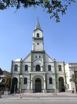
Aguilares

|
||
| Basic data | ||
|---|---|---|
| location | 27 ° 26 ′ S , 65 ° 37 ′ W | |
| Height above d. M .: | 372 m | |
| Population (2010): | 32.097 | |
|
|
||
| administration | ||
| Province : |
|
|
| Department : | Río Chico | |
| Mayor: | Agustín Fernández, SD | |
| Others | ||
| Postal code : | T4152 | |
| Telephone code: | 03865 | |
Aguilares is the capital of the Río Chico department in the southwestern part of the Tucumán Province in northwestern Argentina . The city lies on a plain at the foot of the Sierras del Aconquija on the Ruta Nacional 38 , between the Río Medinas in the north and the Arroyo Barrientos in the south, and is 85 kilometers from the provincial capital San Miguel de Tucumán . Aguilares has 32,097 inhabitants (2010, INDEC ) and is known as the city of Avenidas because of its wide boulevards and its carnival parades.
climate
The climate in summer varies between warm and hot, it is rainy and semi-humid; in winter it is fresh and dry (subtropical climate with dry season). The mean temperatures are 25 degrees Celsius in summer, 20 degrees Celsius in autumn, 13 degrees Celsius in winter and 20 degrees Celsius in spring. The annual mean is between 14.3 and 25.7 degrees Celsius with an average annual temperature of 19.2 degrees Celsius. The annual rainfall reaches 920 millimeters. The period with the most rainfall is from November to March; the lowest rainfall occurs between June and September.
history
The land on which the city of Aguilares was built was part of the lands given to Luis de Medina towards the end of the 16th century . They were known under the name Estancia de San Luis and the fertile soil was the reason for the later settlement.
When the first public school opened in 1870, it was called Los Aguilares , after the largest landowner at the time, Don Pedro de Aguilar . In 1875 the region was opened up for agricultural use and since 1883 the small settlement has been given the name Villa de Aguilares . The development plan of the place dates from January 1889 and is signed by the engineer Modesto Sosa , who determines the railway station as the eastern city limit.
The arrival of the first El Provincial passenger train (line: La Madrid - San Miguel de Tucumán) in 1889 spurred the agricultural development of the place, especially the expansion of sugar cane cultivation and the cultivation of vegetables and fruits.
The formation of a parish is characterized by the construction of the parish church in 1894 and a social center in 1896. Only years later, on May 25, 1901, the central square of the parish is determined. The rapid economic development of the place in a few decades leads to the granting of city rights on December 23, 1915. Ramón Simón becomes the first mayor . In the years from 1947 to 1980, Aguilares experienced further population growth. The number of new districts is growing and the spatial expansion of Aguilares goes beyond the originally defined local limits.
economy
Two important Ingenios (sugar refineries) are located in Aguilares ( Ingenio Aguilares and Ingenio Santa Barbara ). There is also a large sports shoe factory , Alpargatas . The agricultural activities outside the sugar sector are concentrated in vegetables , citrus fruits , tobacco and cereals .
sons and daughters of the town
- Héctor Zaraspe (* 1930), ballet dancer, choreographer and ballet teacher
Web links
- IFAM Population Statistics (Spanish)

