Aidenried
|
Aidenried
Municipality of Pähl
Coordinates: 47 ° 56 ′ 34 ″ N , 11 ° 9 ′ 10 ″ E
|
|
|---|---|
| Height : | 593 m above sea level NHN |
| Residents : | 207 (May 25 1987) |
| Postal code : | 82396 |
| Area code : | 08808 |
|
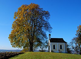
Maria Schnee chapel
|
|
Aidenried is a district of Pähl in Upper Bavaria .
geography
Aidenried is located north of Fischen am Ammersee .
history
The exact origin of the settlement is not known, it may be a settlement of fish. The earliest mention of Aidenried is 1307 as Nordaerriede, which is translated as northern clearing. The place name Aidenried indicates a time of origin around the turn of the millennium as " clearing of the Aito". However, row graves from the early Middle Ages were found in the area even from the period between 600 and 800.
The most important landlord of Aidenried, along with various noble families, was the Dießen monastery from the middle of the 14th century .
According to oral tradition, there was a castle ( Burg Eschenlohe ) belonging to the Counts of Eschenlohe on the “Hungerbichl” in the north of the village , which later came into the possession of the cathedral chapter of Augsburg.
Aidenried belonged to the municipality of Fischen am Ammersee , which was incorporated into Pähl on May 1, 1978.
Attractions
- Maria Schnee chapel (1877)
Web links
Individual evidence
- ↑ Aidenried, in: Working group for local history research in the Würm region: Materials for local history research in the Würm region , Gauting 2001, pp. 4–5.
- ^ Federal Statistical Office (ed.): Historical municipality directory for the Federal Republic of Germany. Name, border and key number changes in municipalities, counties and administrative districts from May 27, 1970 to December 31, 1982 . W. Kohlhammer GmbH, Stuttgart / Mainz 1983, ISBN 3-17-003263-1 , p. 596 .
