Akademika Obrucheva Mountains
| Akademika Obrucheva Mountains | ||
|---|---|---|
| Highest peak | nameless summit ( 2895 m ) | |
| location | Republic of Tuva ( Russia ) | |
|
|
||
| Coordinates | 52 ° N , 96 ° E | |
| rock | Granite , mica slate , sandstone | |
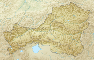
The Akademika Obrucheva Mountains ( Russian Обручева академика хребет , "Academician Obruchev") is located in the northeast of the Russian Republic of Tuva in southern Siberia .
The mountain range extends over a length of 250 km in WNW-ESE direction between the rivers of the Great and Little Yenisei . It separates the Todscha Basin in the north from the Ulug Chem Basin (eastern part of the Tuvinian Basin ) in the south. The mountain range forms the central part of the East Tuvinian Highlands . The Akademika Obrucheva Mountains in the eastern part reach a maximum height of 2895 m . In the east, the mountain range is delimited by the Bilin river valley shortly before the Mongolian border . The mountains consist of granite , crystalline mica slate and sandstone . Taiga forest grows on the mountain slopes . At higher altitudes one encounters mountain tundra and gravel surfaces. The mountain range was named after the Russian geologist, geographer and writer Vladimir Afanassjewitsch Obruchev (1863-1956).
Mountains (selection)
A number of peaks along the main ridge of the Akademika Obrucheva Mountains are listed below, sorted from west to east:
![]() Map with all coordinates: OSM | WikiMap
Map with all coordinates: OSM | WikiMap
- nameless summit ( 2895 m ) ( ⊙ )
Web links
Individual evidence
- ↑ a b c d e article Akademika-Obrucheva Mountains in the Great Soviet Encyclopedia (BSE) , 3rd edition 1969–1978 (Russian)
