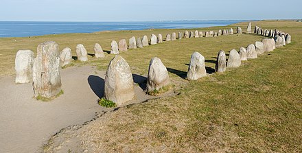
Ales stenar
Ales stenar or Ale stenar ( German "The Stones of Ale" ) in the Swedish municipality of Ystad in Schonen (Skåne) is 67 meters long and 19 meters wide, one of the largest preserved ship settlements ( Swedish skeppssättning ) in Scandinavia . The stones are considered to be of imperial interest and are a popular attraction.
description
The ship set, consisting of 59 stones, is located on a 37 meter high hill directly on the Baltic Sea coast near the town of Kåseberga in the south of Skåne. The coastline is characterized by a precipice sloping steeply to the sea.
The stones, which weigh between 0.5 and 1.8 tons, are arranged in the shape of a ship. The approximately three meter high stern stones at the bow and stern are the largest; the height of the stones decreases from there towards the middle. While the majority of the stones are made of locally occurring sandstone , some stones are made of Hardebergas sandstone, which was quarried about 20 kilometers away at Simrishamn .
During excavations led by Märta Strömberg in 1997, worked flint stones, ceramic shards and an urn with fragments of burned human bones and charcoal were found in the complex , which were dated to the Vendel period (around 600 AD) using the C14 method , which was also is confirmed by the decor of the urn. It is assumed that the objects found coincide with the settling of the ship.
The layout has been changed several times since it was first drawn in 1777. At that time there were two groups of three stones each to the right and left of the central ship setting, which were interpreted as smaller ships setting. You disappeared today; Investigations of the site carried out in 2006 using georadar and magnetometer revealed changes in the soil in this area. Before the first renovation in 1916, only 16 of the 59 stones stood upright, and a large part of the system was covered with drifting sand . At that time some stones were raised and the drift sand removed. As there are insufficient records of the work, it is unclear whether some stones such as the rudder stone at the stern were added. For the so-called altar stone a height of 2.75 meters was given in 1916, while when the next exposure in 1956 was only 1.40 meters; Here, too, the stone can be replaced or damaged. During this second restoration, the sand and soil around the stones were removed with heavy machinery, an archaeological investigation and documentation of the changes were omitted.
In 2006, the contours of a circle with a rectangular structure in its center were detected north of the facility. This is interpreted as a possible indication that Ales stenar was originally part of a larger complex.
The interpretation of the complex by the amateur archaeologist Bob G Lind, who sees a Bronze Age solar calendar in Ales stenar , is unanimously rejected by experts. Nevertheless, in addition to the classic interpretation as a grave complex, his assessment is shown on the signs put up by the Riksantikvarieämbetet in 2007 .
The Swedish poet Anders Österling (1884–1981) describes Ales stenar in his best-known poem Ales stenar from the collection of poems Tonen från havet (1933).
photos
literature
- Märta Strömberg: Det stora skeppet på åsen , in: Jonas Ellerström (Ed.): Amico Amici - Gad Rausing den 19 maj 1997 , Signum, Lund 1997, ISBN 91-87896-30-3 , pp. 51-71
Web links
- Ales stenar - entry in the database "Fornsök" des Riksantikvarieämbetet (Swedish)
- Description ( memento of March 3, 2007 in the Internet Archive ) of the Riksantikvarieämbetet
- Ales Stenar on Großsteingräber.de
Individual evidence
- ↑ Riksantikvarieämbetet: Fördjupad information ( page no longer available , search in web archives ) Info: The link was automatically marked as defective. Please check the link according to the instructions and then remove this notice.
- ↑ a b c Riksantikvarieämbetet: Historical facts about Ales stenar ( Memento from July 9, 2011 in the Internet Archive )
- ↑ a b c Ales stenar ( Memento from March 3, 2007 in the Internet Archive ) - Description of the Riksantikvarieämbetet
- ↑ Bob G Lind: Varför byggdes Ales stenar? (PDF; 2.4 MB) Accessed February 7, 2011 .
- ↑ Elizabeth Rudebeck: Ales stones lider skeppsbrott i ämbetsmannapekoral: Skyltar, språk och och communication vid en controversial fornlämning . In: Gropar & monument: en vänbok till Dag Widholm . 2008, ISBN 978-91-85993-04-8 , pp. 27-52 .
Coordinates: 55 ° 22 ′ 58 ″ N , 14 ° 3 ′ 15 ″ E


