
Kåseberga
| Kåseberga | ||||||
|
||||||
| State : | Sweden | |||||
| Province (län): | Skåne County | |||||
| Historical Province (landskap): | Gentle | |||||
| Municipality : | Ystad | |||||
| Coordinates : | 55 ° 23 ' N , 14 ° 4' E | |||||
| SCB code : | S3517 | |||||
| Status: | Småort | |||||
| Residents : | 118 (December 31, 2015) | |||||
| Area : | 0.29 km² | |||||
| Population density : | 407 inhabitants / km² | |||||

Kåseberga is a town ( småort ) in the Swedish province of Skåne län and the historic province (landskap) of Skåne . The fishing village is located about 18 km southeast of Ystad in the municipality of Ystad .
The village is located immediately to the east of a headland with a steep coast over 20 m high . On the headland is the stone ship Ales stones , the largest stone ship in Sweden. The narrow beach on both sides of the village in front of the cliff is stony and not usable for tourists. The small fishing port below the steep coast was planned in its current form in 1881 with a path breakthrough through the somewhat lower steep coast. Already in 1864 there were 24 fishermen with 9 rowing boats in Kåseberga. Today the place lives from tourism, among other things.
From 2007 to 2016 there was a museum of the Swedish Sea Rescue Service Svenska Sällskapet för Räddning af Skeppsbrutne in the port .

View over the village

port
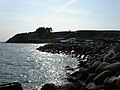
Kåseberga coast

Kåseberga promenade


Web links
Individual evidence
- ↑ a b Statistiska centralbyrån : Småorter 2015, byggnader, areal, överlapp tatorter, coordinater (Excel file)
- ^ Rune Bunte: Fiske och fiskelägen i Skåne . In: Skånsk kust . 1977, ISSN 0347-2418 , p. 65-114 .
Perpetrator: Glemmingebro | Hedeskoga | Köpingebro | Löderup | Nybrostrand | Sövestad | Stora Herrestad | Svarte | Vallösa | Ystad
Småorter: Balkåkra | Bjäresjö | Ensligheten | Hedvigsdal | Ingelstorp | Kåseberga | Knickarp (part) | Rögla | Sjörup | Skårby | Snårestad | Stora Köpinge | Svenstorp